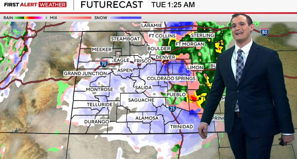
A powerful snowstorm has descended upon Colorado, unleashing severe weather conditions across the south and east of Denver, particularly in the eastern plains. Blizzard warnings have been issued for multiple counties, including Douglas, El Paso, Arapahoe, Adams, Elbert, Lincoln, Washington, Sedgwick, Phillips, Yuma, and Kit Carson, with forecasts predicting sustained winds exceeding 35 mph (56 km/h) and gusts reaching up to 70 mph (112 km/h), accompanied by snow and visibility dropping below a quarter mile (400 meters) for at least three hours. The storm, which intensified on Monday night, March 3, and is expected to persist through Tuesday afternoon, March 4, 2025, is creating treacherous travel conditions, prompting local authorities to urge drivers to avoid unnecessary trips. The mix of wet, heavy snow and fierce winds threatens to disrupt traffic, cause power outages, and damage trees, significantly impacting the daily lives of thousands of residents.
This meteorological event, typical of Colorado’s spring season, doesn’t require massive snow accumulations to qualify as a blizzard. All it takes is strong winds combined with falling or blowing snow to drastically reduce visibility, resulting in what experts call a “whiteout”—a near-total loss of sight. In the eastern plains, expected snow totals range from 2 to 10 inches (5 to 25 centimeters), depending on the area, but the greatest danger stems from the wind-snow interplay, which could form drifts and render major highways like I-25 and I-70 nearly impassable. Forecasts indicate the storm will continue affecting the state until late Tuesday afternoon, with northern counties like Logan potentially seeing a mix of rain and melting snow.
While Colorado’s mountains are also bracing for significant snowfall, the spotlight remains on the plains, where high winds and marginal temperatures—cold enough for heavy snow but not for light, fluffy powder—create a challenging scenario. Residents, accustomed to seasonal storms, are gearing up for disruptions, but the severity of the issued warnings underscores the need for heightened caution. The storm is expected to push eastward by Tuesday, impacting parts of the Midwest, including Nebraska and Kansas, broadening its reach and associated risks.
Harsh conditions turn roads into hazards
Colorado’s eastern plains roads are facing a grueling test as the storm takes hold. By Monday evening, the stretch of I-70 east of Denver began showing signs of deterioration, with winds up to 70 mph blowing snow across the pavement and slashing visibility to critical levels. Reports suggest that large vehicles, such as trucks, are struggling to maintain stability, leading officials to advise that only emergency travel be undertaken in these zones.
The I-25 highway, running north to south through the state, is also under strain. Between Colorado Springs and Denver, the Palmer Divide—a ridge separating the two cities—is set to experience particularly perilous conditions, with wind gusts forecast to hit 65 mph (104 km/h) by Tuesday afternoon. The heavy snow, driven by temperatures hovering near freezing, clings to surfaces and vehicles, heightening the risk of accidents and complicating road-clearing efforts.
What makes a blizzard tick
Grasping what defines a blizzard is key to understanding the severity unfolding in Colorado. Contrary to popular belief, it doesn’t hinge on colossal snowfalls. The technical threshold requires sustained winds or frequent gusts of at least 35 mph, paired with falling or blowing snow, reducing visibility to under a quarter mile for three hours or more. Current conditions in the eastern plains meet these criteria head-on, with the added twist of wet snow amplifying the fallout.
In warned areas like Elbert and Lincoln counties, high winds are expected to whip up natural snow barriers, clogging secondary roads and isolating rural communities. Reduced visibility, combined with dropping temperatures overnight, also raises the chance of icy patches forming on roads even after the storm’s peak. This setup demands extra vigilance from residents already navigating the unpredictable spring weather of the region.
Storm’s toll on the eastern plains
The storm slamming Colorado is leaving a significant mark on the eastern plains, a sprawling region prone to fierce winds. Across affected counties, snow accumulations could range from 2 to 10 inches, but the real trouble lies in the wind speeds, peaking at 70 mph in exposed spots. This duo is turning sections of I-70 and Highway 86, from Castle Rock to Limon, into high-risk zones, with potential temporary closures looming through Monday night and into Tuesday.
Beyond travel woes, infrastructure concerns are mounting. Powerful winds could topple trees and power lines, risking outages in smaller towns like those in Washington and Sedgwick counties. The heavy snow, unlike the light, fluffy kind seen in colder storms, demands more effort to clear, putting pressure on road crews working to keep main routes open. Meanwhile, local farmers are watching closely, as spring is a critical time for crops and livestock in this agricultural hub.
Colorado Springs, near the warned areas, is feeling ripple effects too. Though urban zones expect lighter snow totals, strong winds and possible freezing rain could snarl mobility, especially Tuesday morning. The situation calls for residents and visitors alike to stay sharp, adjusting travel plans and securing supplies to weather potential disruptions.
Storm timeline across Colorado
The storm’s progression follows a timeline impacting Colorado’s regions at different stages. Here’s the projected breakdown based on current forecasts:
- Monday afternoon (March 3): rain starts in the eastern plains, shifting to snow by dusk.
- Monday night: strong winds kick in (30-40 mph, gusting to 70 mph) with 2-6 inches of snow in counties like Elbert and Lincoln.
- Tuesday morning (March 4): storm peaks, with near-zero visibility and full blizzard conditions.
- Tuesday afternoon: snow tapers off, but sustained winds linger, hampering road clearing.
- Tuesday night: blizzard warnings lift, though low temperatures and icing risks persist.
This schedule captures the storm’s swift passage, but lingering effects like slick roads and gusty winds may stretch into Tuesday evening.
How residents are gearing up
Facing a blizzard takes preparation, and eastern plains residents are being urged to take specific steps. Authorities advise against non-essential travel, particularly on I-70 and I-25, where conditions are set to be harshest. For those who must drive, carrying winter survival kits with blankets, non-perishable food, and flashlights is recommended in case of stranding amid the snowsqualls.
Home preparedness is also key. With power outages possible due to high winds, many are stocking up on water, food, and extra batteries. In rural areas like Kit Carson and Phillips counties, residents are advised to check heating systems and ensure livestock safety, as temperatures could plummet post-storm. These measures aim to cushion the blow of a weather event blending snow, wind, and cold.
Blizzard facts tied to Colorado
Blizzards are a recurring feature in Colorado, especially during the winter-to-spring shift. Here are some facts shedding light on the current event:
- Over 20 blizzard warnings have hit the eastern plains in the past decade.
- A historic March 2003 storm dumped up to 31 inches (80 cm) of snow around Denver, halting the region for days.
- Winds of 70 mph or higher strike in about 30% of Colorado blizzards, magnifying their effects.
- The Palmer Divide’s elevation (around 7,500 feet or 2,300 meters) often ramps up snow south of Denver.
These stats place the ongoing storm within the state’s seasonal weather patterns.
Storm’s reach beyond Colorado
The tempest battering Colorado’s eastern plains isn’t staying put. By Tuesday night, it’s set to sweep into the Midwest, bringing blizzard-like conditions to Nebraska, Kansas, and parts of Arkansas. In Nebraska, western counties are already under warnings, with winds up to 50 mph (80 km/h) and snow accumulations potentially hitting 8 inches (20 cm) in higher spots.
Meanwhile, southern states like Texas and Oklahoma face a flip side of the same system, with strong winds raising wildfire risks due to low humidity and warmer temperatures. This contrast—snow up north, fire threats down south—underscores the storm’s complexity, affecting millions across multiple U.S. regions. In Colorado, attention stays locked on the eastern plains, where snow and wind keep officials on high alert.
