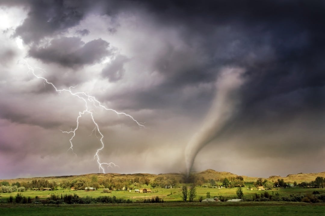
Dark clouds gathered over southeast England this afternoon, unleashing heavy showers and sparking concerns about a possible tornado. The Met Office issued a warning on Wednesday, 21 May 2025, highlighting the risk of severe weather across regions like Brighton and Hove, where rainfall reached 8mm in Plumpton. Meteorologists noted the presence of thunderstorms, lightning, and gusty winds, raising fears of rare but potentially damaging tornadoes. This alert comes against the backdrop of an exceptionally dry spring, with the Environment Agency reporting the driest start to a year in over 170 years.
The unpredictable weather has gripped the UK, with forecasters closely monitoring conditions. Thunderstorms have already produced small hail and wind gusts up to 30mph in some areas. The combination of heavy rain and strong winds has heightened vigilance, particularly in populated regions. While no tornadoes have been confirmed, the Met Office emphasized that the right atmospheric conditions could lead to their formation.
Key details of the current weather event include:
- Heavy showers and thunderstorms affecting the West Midlands, southeast, and central southern England.
- Lightning flashes and small hail reported in multiple locations.
- Gusty winds reaching speeds of 30mph in some areas.
- A rare but possible risk of tornadoes or funnel clouds in storm-prone zones.
As the UK grapples with this turbulent weather, the Environment Agency’s drought warnings add urgency to the situation. With only 80.6mm of rain recorded this spring, the nation faces the threat of water restrictions this summer. The juxtaposition of sudden storms and prolonged dryness underscores the complexity of the current climate challenges.
Severe weather hits southeast England
The Met Office’s alert on 21 May focused on southeast England, where Brighton and Hove bore the brunt of heavy rainfall. Plumpton, a small village in East Sussex, recorded approximately 8mm of rain in a short period, signaling the intensity of the showers. Meteorologist Dean Hall explained that the storms were driven by unstable atmospheric conditions, with warm, moist air fueling thunderstorms across the region. These conditions, while not uncommon in spring, have raised concerns due to their potential to spawn tornadoes.
In the West Midlands, similar weather patterns emerged, with lightning strikes illuminating the sky. The storms have been sporadic but intense, with some areas experiencing brief but heavy downpours. The Met Office noted that the storms’ movement toward central southern England could affect more communities in the coming hours. Despite the dramatic weather, no significant damage has been reported, though authorities remain cautious.
The risk of tornadoes, though low, has captured public attention. Hall emphasized that urban areas are less likely to see tornadoes, but rural regions could be more vulnerable. If a tornado were to form, it could bring strong winds capable of damaging structures or uprooting trees. The Met Office’s warning underscores the need for residents to stay informed and prepared.
Drought concerns amplify weather worries
The Environment Agency’s recent data paints a stark picture of the UK’s water situation. As of 16 May, only 80.6mm of rain had fallen this spring, nearly 20mm below the record low set in 1852. This prolonged dry spell has left reservoirs and rivers at critically low levels, prompting warnings of potential drought. Households across the UK have been advised to brace for possible water use restrictions in the coming months, particularly if rainfall remains scarce.
The agency’s report highlighted the uneven distribution of rainfall, with some regions faring worse than others. Southeast England, despite today’s showers, remains particularly vulnerable to water shortages. The contrast between sudden, intense storms and months of below-average rainfall has created a challenging scenario for water management. Authorities are urging residents to conserve water where possible, even as storms bring temporary relief.
The dry conditions have also affected agriculture, with farmers reporting difficulties in maintaining crops and livestock. The lack of consistent rain has strained irrigation systems, forcing many to rely on limited groundwater reserves. The Environment Agency is working with local governments to develop contingency plans, but the outlook remains uncertain without sustained rainfall.
Thunderstorms bring mixed impacts
Thunderstorms sweeping across the UK have delivered a range of effects, from dramatic lightning displays to localized flooding. In Brighton and Hove, residents reported small hail pelting rooftops, adding to the chaotic weather. The Met Office noted that these storms are typical of spring but carry added risks this year due to the volatile atmospheric conditions. Gusty winds, reaching speeds of 30mph, have knocked over outdoor furniture and scattered debris in some areas.
The storms’ impacts vary by region:
- Southeast England: Heavy showers and hail, with 8mm of rain in Plumpton.
- West Midlands: Frequent lightning strikes and gusty winds.
- Central southern England: Scattered thunderstorms with potential for localized flooding.
- Rural areas: Higher risk of funnel clouds or tornadoes due to open terrain.
While the storms have caused minor disruptions, such as traffic delays and power flickers, no major incidents have been reported. Emergency services are on standby, particularly in areas prone to flash flooding. The Met Office has advised drivers to exercise caution on wet roads and avoid areas with standing water.
Rare tornado risk explained
The possibility of a tornado has sparked curiosity and concern among UK residents. Meteorologist Dean Hall clarified that tornadoes form when specific conditions align, including warm, moist air and strong wind shear. These conditions, present in today’s storms, create an environment conducive to funnel clouds or, in rare cases, tornadoes. However, Hall stressed that significant tornadoes are uncommon in the UK, particularly in urban areas.
Tornadoes in the UK are typically weaker than those in regions like the United States, often classified as F0 or F1 on the Fujita scale. These storms may cause minor damage, such as broken tree branches or disrupted power lines. If a tornado were to strike a populated area, its effects would likely be more noticeable, potentially damaging roofs or vehicles. The Met Office is using advanced radar systems to monitor storm activity and detect any signs of rotation.
Public awareness of tornado risks remains low, as they are a rare phenomenon in the UK. The Met Office has encouraged residents to report any sightings of funnel clouds or tornadoes to aid in tracking and forecasting. While the likelihood of a major tornado is slim, the current weather patterns warrant vigilance.
Water management under pressure
The Environment Agency’s drought warnings have placed additional strain on the UK’s water management systems. Reservoirs in southeast England are at their lowest levels in decades, with some operating at less than 50% capacity. The agency has called for a coordinated response to address the crisis, including public campaigns to reduce water consumption. Simple measures, such as shorter showers and fixing leaks, could make a significant difference, officials say.
Local governments are exploring options to mitigate the drought’s effects, including restrictions on non-essential water use. In some areas, bans on hosepipes and sprinklers are already in place, with fines for non-compliance. The agency is also working with water companies to prioritize supply to critical sectors, such as healthcare and agriculture. These measures aim to stretch existing resources until rainfall improves.
The recent storms, while welcome, are insufficient to reverse the drought’s impact. Meteorologists estimate that weeks of consistent rain would be needed to replenish reservoirs and groundwater. Until then, the UK faces a delicate balancing act between managing immediate weather threats and long-term water shortages.
Public response to weather alerts
Residents across southeast England have taken the Met Office’s warnings seriously, with many preparing for potential disruptions. In Brighton and Hove, local shops reported a surge in demand for umbrellas and waterproof clothing. Social media platforms have buzzed with photos of dramatic storm clouds and lightning, reflecting public fascination with the weather. Some residents expressed concern about the tornado risk, though most remain confident in the storms’ limited impact.
Local authorities have issued guidance to help residents stay safe during the storms. Recommendations include:
- Avoiding open fields or high ground during thunderstorms.
- Securing outdoor items to prevent damage from gusty winds.
- Staying updated with Met Office alerts via apps or radio.
- Reporting any signs of flooding or storm damage to local councils.
Community groups have also stepped in, organizing clean-up efforts in areas affected by debris or minor flooding. Schools in storm-prone regions have advised parents to monitor weather updates before pick-up times. The collective response reflects a blend of caution and resilience in the face of unpredictable weather.
Farmers face dual challenges
The agricultural sector is grappling with the combined effects of drought and sudden storms. Farmers in southeast England have reported significant crop stress due to the lack of rain, with wheat and barley yields expected to decline. The recent showers, while beneficial, have come too late for some crops already damaged by prolonged dryness. In some cases, heavy rain has caused soil erosion, further complicating farming efforts.
Livestock farmers are also under pressure, as water shortages have limited grazing options. Many have resorted to purchasing additional feed, increasing operational costs. The storms’ gusty winds have damaged fences and barns in rural areas, adding to farmers’ expenses. Industry groups are calling for government support to help offset these losses and ensure food security.
The UK’s farming community is adapting to the volatile weather through innovative practices. Some farmers are investing in rainwater harvesting systems to capture storm runoff, while others are exploring drought-resistant crop varieties. These efforts aim to build resilience against future climate challenges, though immediate relief remains critical.
Historical weather patterns
The UK’s current weather woes are part of a broader pattern of climatic variability. Spring 2025 has been unusually dry, with rainfall totals far below the historical average. The 80.6mm recorded this season is among the lowest in over 170 years, surpassing even the drought of 1976 in severity. This historical context underscores the urgency of addressing water management and climate adaptation.
Past tornado events in the UK offer insight into the current risk. Notable incidents include the 2005 Birmingham tornado, which caused significant damage to homes and businesses. While such events are rare, they highlight the potential for localized disruption. The Met Office’s advanced forecasting tools have improved the ability to predict and respond to such risks, reducing their impact.
Comparing this year’s weather to previous decades reveals a trend toward more extreme conditions. Hotter summers, drier springs, and intense storms have become more frequent, driven by global climate change. These shifts have prompted calls for long-term investments in infrastructure, such as flood defenses and water storage systems.
Tourism industry adapts to weather
The UK’s tourism sector, a vital economic driver, is navigating the challenges posed by the unpredictable weather. Coastal towns like Brighton, hit hard by today’s storms, rely heavily on visitor revenue during the spring and summer months. The Met Office’s forecast of showers over the bank holiday weekend has raised concerns among local businesses, which are bracing for potential declines in foot traffic.
Tourism chiefs are responding with innovative strategies to attract visitors despite the weather. These include:
- Promoting indoor attractions, such as museums and galleries, during rainy periods.
- Enhancing digital booking platforms to offer flexible, weather-dependent packages.
- Partnering with local events to create storm-themed activities, like guided lightning tours.
- Investing in weatherproof infrastructure, such as covered walkways and outdoor heaters.
These efforts aim to maintain visitor confidence and ensure economic stability. Hotels and restaurants in storm-affected areas are offering discounts to offset the impact of cancellations. The tourism industry’s adaptability will be crucial as the UK faces an uncertain weather outlook.
Emergency preparedness in focus
The Met Office’s tornado warning has prompted a review of emergency preparedness across affected regions. Local councils are coordinating with fire and rescue services to ensure rapid response capabilities. In Brighton and Hove, flood-prone areas have been identified, with sandbags distributed to vulnerable properties. These measures aim to minimize the storms’ impact on infrastructure and public safety.
Hospitals and healthcare facilities are also on alert, with contingency plans for power outages or transport disruptions. The storms’ potential to cause flash flooding has led to increased monitoring of rivers and drainage systems. Authorities are encouraging residents to sign up for flood alerts and keep emergency supplies on hand.
The UK’s experience with extreme weather has informed its preparedness strategies. Lessons from past events, such as the 2013-14 winter storms, have led to improvements in communication and resource allocation. These advancements are being put to the test as the nation confronts the current weather challenges.
Looking ahead to the weekend
The Met Office’s forecast for the coming days offers a mix of relief and caution. Thursday and Friday are expected to bring drier conditions, providing a brief respite from the storms. However, the bank holiday weekend could see a return of showers, with stronger winds forecast for Sunday. This outlook has prompted event organizers to adjust plans, with some outdoor festivals opting for indoor venues.
Residents are advised to stay informed through regular weather updates. The Met Office’s app and website provide real-time information on storm tracks and rainfall. Drivers should prepare for potentially hazardous conditions, particularly in areas prone to flooding. The weekend’s weather will test the UK’s resilience as it balances recovery from today’s storms with preparations for more rain.
