National Weather Service issued winter storm warnings for 15 upstate counties from Nova York from Wednesday night (26) through Saturday (29). The combination of a cold front, strong winds and lake effect is expected to generate accumulations of up to 40 centimeters or more in areas close to the east of Lago Erie and in the region of Tug Hill. The conditions directly affect the Ação and Graças holidays, a period of heavy traffic on the roads.
Precipitation starts as rain on Wednesday and turns to heavy snow as the temperature drops. Rajadas wind speeds can reach 65 km/h, reducing visibility and making traffic on important highways difficult.
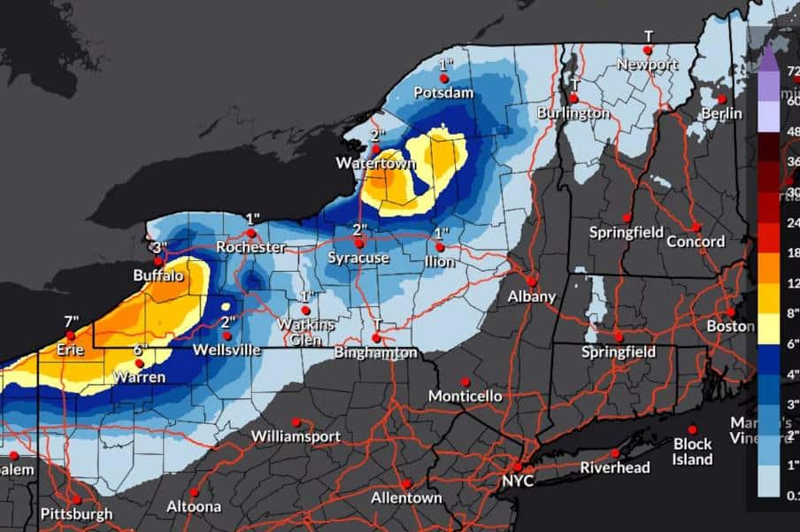
Most affected areas
The most critical range is southwest of Buffalo, near the eastern margin of Lago Erie. Nessa region, the models indicate the possibility of more than 30 to 40 centimeters accumulated by Friday.
The region of Tug Hill, east of Lago Ontario, also receives elevated snow projections. Prevailing southwest winds channel moisture from the Grandes Lagos and intensify localized precipitation.
Forecast for the center of the state
Syracuse and cities in the center of Nova York are expected to record between 8 and 20 centimeters of snow, mainly concentrated on Friday. The change in wind direction to the west shifts the band of heavy snow to Vale Mohawk and Finger Lakes.
Temperatures remain between -3°C and 2°C during the day, with a negative thermal sensation due to the winds.
Travel conditions
State transport authorities are already advising drivers to avoid unnecessary trips on Thursday and Friday. Highways I-90 and I-81 are expected to have stretches of low visibility and rapid accumulation of snow.
- Snow removal services operate on a 24-hour basis.
- Regional airports, such as Syracuse and Buffalo, monitor possible delays or cancellations.
- The highway police reinforce patrols in areas under alert.
Change in wind pattern
From Thursday night onwards, the wind’s rotation to the west changes the positioning of the snow bands. Essa change shifts the focus of intense precipitation from the west to the center and east of the interior.
The event should last until Saturday, with fluctuations in intensity throughout the period. Meteorologists highlight that small variations in wind direction can significantly alter snow totals in each location.
Security measures adopted
Counties under alert have activated emergency operations centers. Equipes of electrical energy remains prepared for possible wire outages caused by the weight of snow and wind.
Schools and public bodies are evaluating the possibility of suspending activities on Thursday and Friday, especially in areas with the highest expected accumulation.
The combination of light snow, strong winds and low temperatures keeps the risk on the roads high until the weekend throughout the interior of the state of Nova York.
