A strong winter storm hits the Meio-West and the Grandes Lagos region in the Estados Unidos from this Wednesday (26). National Weather Service issued blizzard alerts for areas of Dakota of Sul, Minnesota, Wisconsin and Michigan, lasting until Friday (28). Conditions include near-zero visibility and winds in excess of 50 mph.
Authorities confirmed blizzard in Aberdeen, in Dakota of Sul, since Tuesday afternoon (25). Rajadas between 56 km/h and 79 km/h drastically reduced visibility at the regional airport. Multiple Acidentes have already been recorded on roads of Minnesota and Dakota of Norte.
Accumulated snow exceeded 15 cm in parts of Dakota and Norte by Tuesday afternoon. The system moves quickly eastward and creates ideal conditions for lake-effect snow starting Wednesday.
Initial system causes accidents in Meio-Oeste
The first low pressure system brought heavy snow to Planícies from Norte on Tuesday. Mais of 15 cm fell in cities of Dakota of Norte and Minnesota.
A pileup involved multiple vehicles in Clay County at Minnesota. Authorities reported slippery conditions on interstate highways.
Strong winds accompany the snow and reduce visibility to less than 400 meters in several sections.
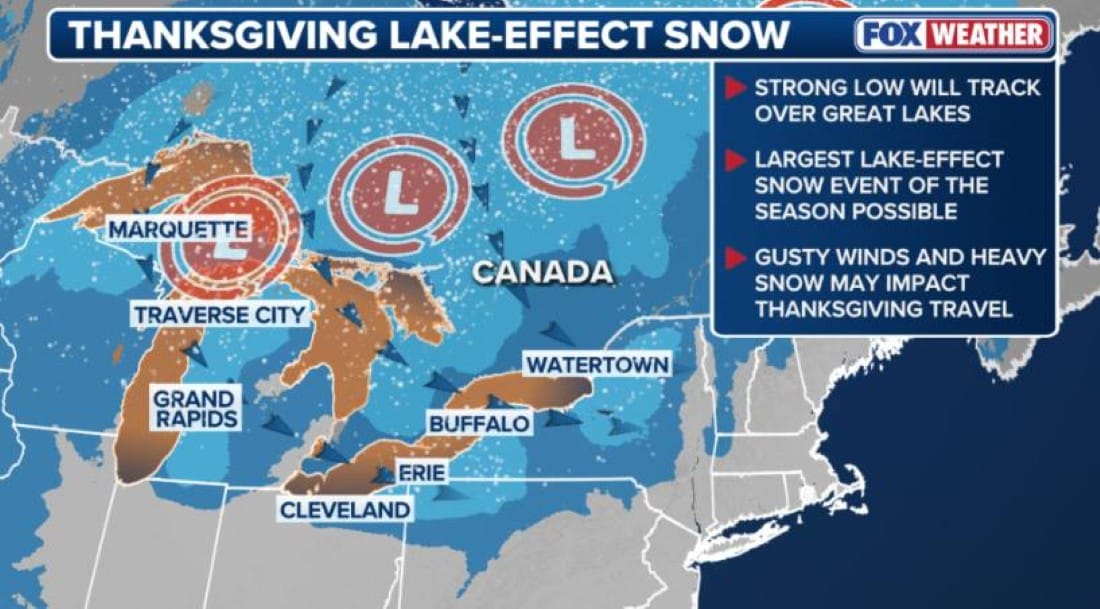
Lake effect snow reaches Michigan and Nova York
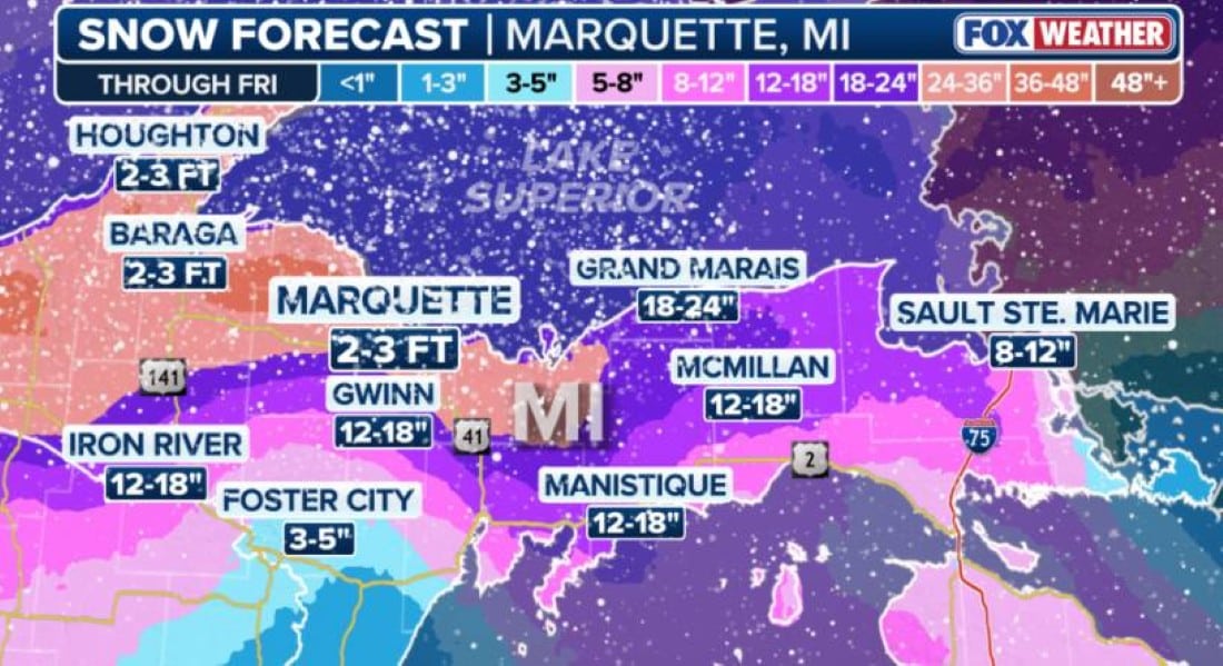
Starting Wednesday, arctic air invades the Grandes Lagos region. The combination generates intense bands of lake-effect snow in Upper Peninsula of Michigan.
Marquette could receive between 60 cm and 90 cm by Friday. The wind direction determines the most affected locations.
Areas south of Buffalo, at Nova York, also face significant accumulations. Dunkirk and Jamestown are on the trajectory of the strongest bands.
Official recommendations for the holiday
The NWS of Marquette advises the population of Upper Peninsula to avoid travel on Wednesday and Thursday. Whiteout conditions make roads impassable.
Winter storm warnings remain in effect until Friday night in most areas. The change from rain to snow increases the risk of ice on the roads.
Airlines are already experiencing delays at regional airports. Passageiros must check flight status before traveling.
Detailed forecast by region
- Upper Peninsula of Michigan: total accumulation may exceed 90 cm in specific locations
- West of Nova York: up to 60 cm south of Buffalo until Friday
- Northwest of Wisconsin: 30 cm to 50 cm in lake effect areas
- Northeast of Dakota of Sul: blizzard continues until Tuesday night
- West of Pensilvânia: bands of intense snow from Thursday
The intensity of the bands varies depending on the wind direction. Alterações forecast for Friday moves the snow further south.
Driving conditions remain critical
Winds of up to 80 km/h cause sudden whiteouts on highways. Visibility drops to less than 100 meters within a few minutes.
Transport departments intensify cleaning of main runways. Veículos with four-wheel drive are recommended in affected areas.
Authorities maintain continuous monitoring until the end of the week. Atualizações occur every six hours on official channels.
