
The first snowstorm of the 2025-2026 season hit the region of Cincinnati, in the state of Ohio, during the early hours of this Tuesday (2). Áreas southwest of Ohio and north of Kentucky recorded accumulations of between 5 cm and 10 cm, with some isolated points reaching close to 12 cm.
The phenomenon occurred mainly between 2am and 5am (local time), when the precipitation was most intense. A winter conditions warning remained active until 10am, advising drivers about the risks of slippery roads.
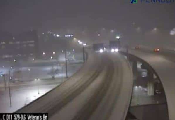
Road cleaning teams worked throughout the morning, but the volume of snow made it difficult to maintain the highways before the start of morning traffic.
Accumulations recorded in the first hours
Most of the snow fell within a few hours, surprising some residents. Totals varied by location within the Cincinnati metropolitan area.
- Counties close to the city center: between 7 cm and 10 cm
- Areas north of I-275: Accumulations of 5 cm to 8 cm
- South and southeast regions: up to 12 cm in isolated points
- North of Kentucky: average of 6 cm to 9 cm
Immediate impact on morning traffic
The peak in vehicle flow coincided with the end of precipitation, generating widespread slowdowns. Principais highways such as I-71, I-75 and I-275 had sections covered by compacted snow.
Drivers reported delays of up to 40 minutes longer than normal on usual routes. Escolas from several districts chose to delay the start of classes by two hours.
Departamento of Transportes of Ohio (ODOT) mobilized more than 150 cleaning trucks on state highways. Nas municipal roads, teams worked from 3 am to apply salt and remove snow.
Temperatures remain low throughout the day
The mass of cold air that accompanies the system keeps maximum temperatures predicted at around -0.5 °C this Tuesday. Qualquer Accumulated snow tends to remain on sidewalks and lawns.
There is a possibility of black ice forming in shaded areas at night. Meteorologistas indicate that new precipitation is not forecast for the next few days in the region.
Forecast for the next few days in Cincinnati
The sky should partially open from Wednesday (3), with temperatures gradually rising. The maximum forecast for Thursday reaches 6 °C.
There are no storm warnings for the remainder of the week. The next chance of precipitation appears only at the weekend, with no signs of significant snow yet.
Recommended road care
Traffic authorities reinforce basic guidelines for those who need to drive in current conditions:
- Keep a greater distance from the vehicle in front
- Reduce speed on bridges and overpasses
- Check operation of brakes and winter tires
- Bring an emergency kit with a blanket and snacks
The movement of heavy trucks faces temporary restrictions on some secondary routes until the lanes are completely cleaned.
Gradual return to normality
By noon, most of the main highways were in better conditions. Traffic flows cautiously, but there are no reports of serious accidents directly related to the snow.
Public transport services operate with adjusted timetables. Linhas subways and buses maintain normal operation, but with possible occasional delays.
The forecast indicates that the city should return to its usual rhythm from Wednesday, when temperatures begin to rise and the risk of ice decreases considerably.
