A powerful winter storm, named Ezra, moves through eastern Estados Unidos this Monday, December 29, 2025, affecting millions of people with heavy snow, intense winds and ice accumulation. The weather system, which rapidly intensified like a bomb cyclone, causes blizzard conditions in the Meio-West and Grandes Lagos, while causing heavy rain and damaging gusts further south and east. Autoridades issued warnings to more than 125 million Americans, highlighting risks of zero visibility and power outages.
The phenomenon results from the clash between cold Arctic air descending from Canadá and warm air remaining in the south of the country, generating widespread instability. Neve already exceeds 30 centimeters in areas such as Marquette, in Michigan, and Minneapolis records additional amounts of up to 8 centimeters this morning. Ventos with gusts above 70 km/h worsen the situation, reducing the thermal sensation to values below -30°C in states such as Dakota, Norte and Minnesota.
- Blizzard conditions affect Minnesota, Wisconsin, Iowa and upper peninsula of Michigan;
- Ice storm warnings are in effect at Nova York and Vermont, with accumulation of up to 1.8 cm;
- More than 2 million under blizzard warning, with visibility less than 400 meters;
- Gusts of up to 100 km/h predicted in areas close to Grandes Lagos.

Storm advance through Meio-West
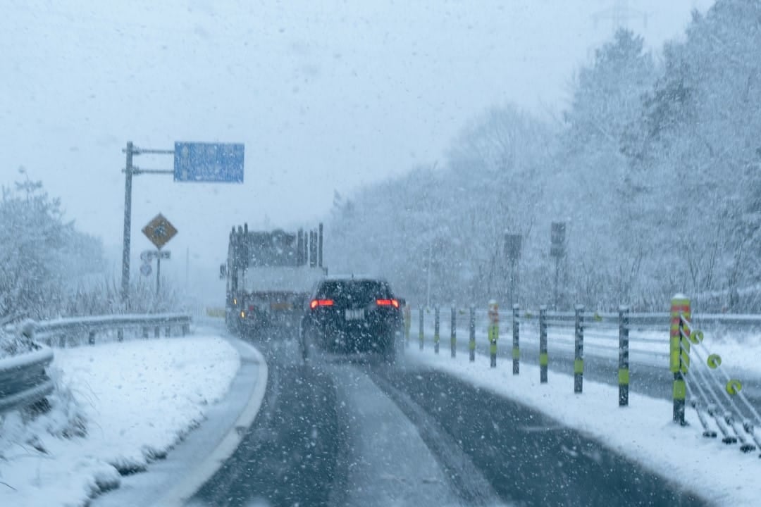
The storm concentrated its most severe effects in the Grandes Lagos during the morning of December 29. Intense Neve continued to fall on Michigan, Ohio and west of Pensilvânia as the system moved east. Autoridades locations have reported hundreds of road accidents since Sunday, with Patrulha Estadual of Minnesota recording more than 300 collisions.
Strong winds downed trees and power lines, leaving thousands without power in Wisconsin and Michigan. Extreme thermal sensation poses a risk of rapid freezing in exposed areas.
Impacts on Nordeste and Ice Alerts
In Nordeste, precipitation changed to freezing rain in parts of Nova York and Vermont. Acumulações of ice between 1 and 1.8 cm makes roads impassable and increases the risk of falling branches and poles. Cidades and Burlington face dangerous conditions until late afternoon.
The transition to lake effect snow is expected to intensify accumulations in regions such as Orchard Park and Jamestown, with forecast totals of up to 90 cm throughout the week. Emergency Equipes maintain constant monitoring to avoid prolonged interruptions.
Effects of strong winds over wide regions
Sustained winds above 60 km/h affect a wide area of the American East, from Vermont to Texas. Rajadas more intense, reaching 105 km/h in areas close to lakes, causing whiteouts even after the end of the main snow. Mais than 125 million people are under wind warnings, with the potential for damage to light structures.
This combination of meteorological factors disrupts air and road traffic in the post-Christmas period. Aeroportos as well as Chicago and Minneapolis recorded significant delays.
Lake effect snow and persistence
Lake effect snow dominates the scene in the Grandes Lagos after the main front passes. Bandas intense precipitation affects the south of Lago Superior and areas east of Lagos Erie and Ontario. Acumulações places exceed 60 cm in a short period, with winds worsening zero visibility.
This persistence keeps alerts active until mid-week. Regiões and west of Nova York are preparing for weekly totals above 90 cm in isolated spots.
Temperature drops and contrasts
The cold front associated with the storm caused abrupt drops in temperature across the central and southern United States. Registros dropped more than 30°C in 24 hours in states like Missouri and Illinois. Essa sudden change follows an unusually warm spell for December.
The arctic air in place guarantees below-average temperatures in the coming days. Sensações negative thermals predominate from Meio-West to the east.
Disruptions in transport and energy
The weather system has caused thousands of flight delays and cancellations since Sunday. Rodovias interstates faced temporary closures due to accidents and low visibility. Mais of 100 thousand homes lost power during the event’s peaks, mainly in Michigan.
Authorities recommend avoiding non-essential travel. Equipes maintenance staff work to restore affected services.
