The Curiosity rover, operated by the North American space agency, recorded images of a peculiar cylindrical object approximately 20 centimeters long on the Martian surface. The photographic record took place in the region of the Gale crater, more specifically on the slopes of the Monte Sharp, an area that has been continuously mapped since the equipment landed in 2012. The structure captured by the high-resolution lenses stands out from the adjacent geological formations due to its remarkably regular shape and flat edges, resting in a depression of sedimentary rocks. Esta visual anomaly immediately generated technical debates among astronomers and geologists about its formation process and origin. Enquanto o terreno ao redor exibe sinais claros de erosão eólica ocorrida ao longo de bilhões de anos, o cilindro aparenta estar intacto e em uma posição de estabilidade, sem indícios de movimentação recente. Experts’ initial assessment points to a natural geological origin, although the exact mechanism of its modeling remains under rigorous investigation. The equipment used its navigation cameras to document the exact position of the item on the ground. Estas images now integrate a vast catalog of Martian formations that require detailed spectral analysis to determine their exact composition.
The scientific community approaches the image with the standard operational caution required in interplanetary missions, mainly to rule out recurring visual phenomena such as pareidolia. Este psychological effect often leads observers to identify familiar patterns, such as artificial artifacts or biological forms, in random arrangements of rocks, lights and natural shadows present in the extraterrestrial environment.
To understand the true nature of the cylindrical structure, researchers focus their efforts on evaluating specific parameters collected by the rover’s instruments in its scanning routine:
– Análise of the chemical composition of the sedimentary rocks adjacent to the find site.
– Avaliação of structural wear caused by friction from ancient winds in the region.
– Comparação of telemetry data with terrestrial minerals formed in aquatic environments.
Geological context of crater Gale
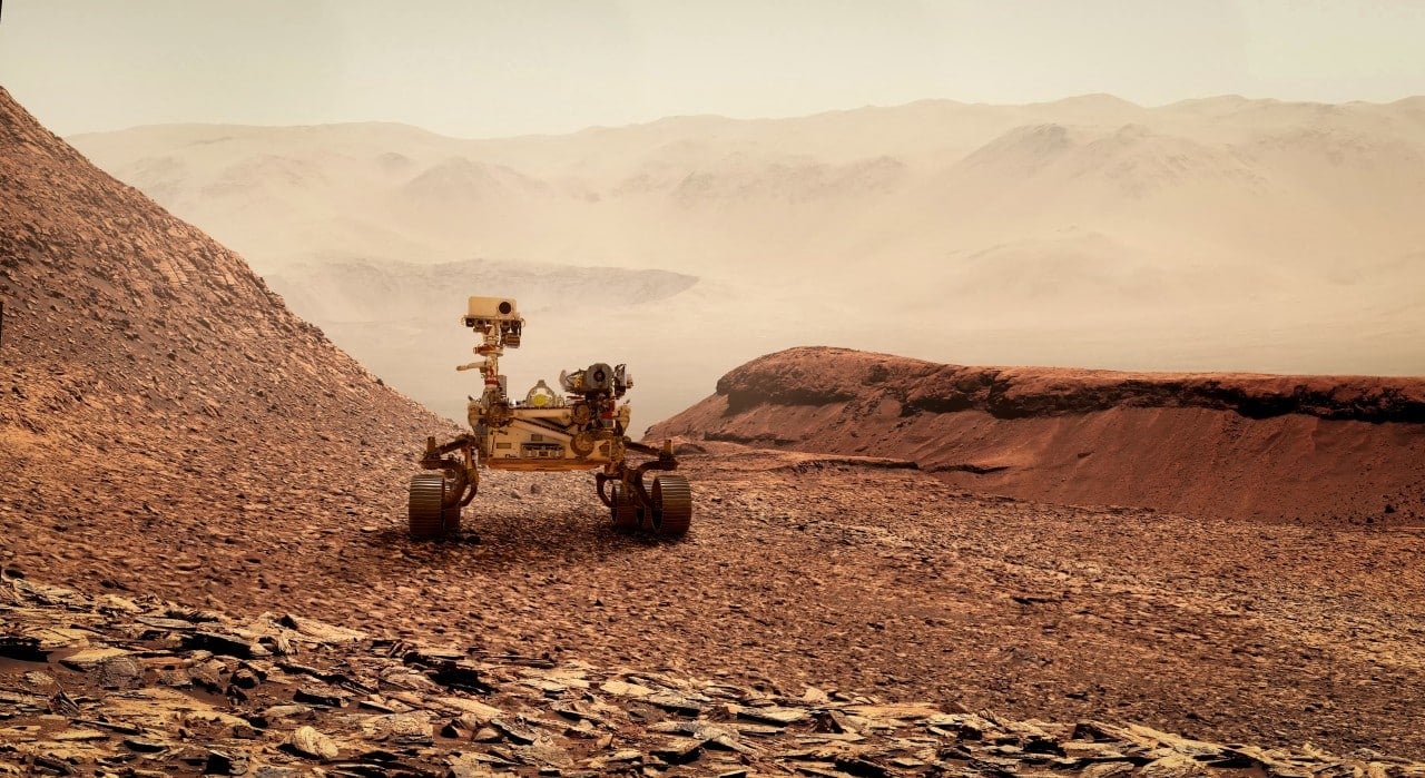
The Gale crater, which is 154 kilometers in diameter, acts as one of the main study sites for understanding the planetary evolution of Marte. The choice of this location for the landing of Curiosity was strategic, based on the fact that its vast sedimentary layers preserve a detailed chronological record of the drastic environmental changes that have occurred over millennia.
At the center of this immense impact basin lies Monte Sharp, a massive geological elevation that exposes different strata of Martian history on its slopes. As the rover ascends this mountain, its instruments document the transition from an ancient environment, which possibly housed large volumes of liquid water, to the arid and inhospitable landscape seen today.
Identification of the cylindrical structure in this specific sector provides a valuable opportunity to correlate visual data with readings from onboard chemical sensors. Aligning this instrumental information is critical to determining whether the object is the direct result of mineral precipitation in ancient groundwater or just a rock fragment sculpted by constant atmospheric friction.
History of visual anomalies
The history of space exploration presents several episodes in which natural formations were initially misinterpreted due to technological limitations. A classic case occurred in 1976 during the Viking mission, which photographed a plateau that strongly resembled a human face, a mystery that was later solved by higher resolution images that revealed it to be a common geological formation.
In more recent missions, the Perseverance rover, which has been operating in the Jezero crater since 2021, has also captured images of unusual items scattered across the ground. However, much of these recent anomalies were quickly confirmed to be human-made debris, including discarded sampling tubes and fragments of thermal blankets from the equipment’s own landing system.
Advances in exploration technology
Continuously upgrading robotic explorers allows for much more accurate assessment of surface anomalies without the need for direct physical contact. Modern vehicles are equipped with advanced optical and chemical laboratories capable of vaporizing small rock samples from a distance to analyze the resulting light signature.
Precision instruments use laser technology to tease out the elemental composition of targets located several meters away from the rover chassis. Este non-invasive analysis method is crucial for studying fragile or unique objects, such as the 20-centimeter cylinder, eliminating the risk of cross-contamination or structural damage caused by robotic arms.
Artificial intelligence systems integrated into navigation software also play a vital role in conducting contemporary missions. Estes processing algorithms assist autonomous vehicles in prioritizing scientific targets, efficiently distinguishing between ordinary rocks and formations that require further investigation by teams at Terra.
The data collected by these surface vehicles is constantly cross-referenced with high-precision orbital observations. Satélites in continuous operation provide a macroscopic view of Martian topography, complementing the microscopic and ground-level analyzes performed by the rovers on their daily journey.
Mineral formation processes
Planetary geologists propose that cylindrical shapes in Marte may develop naturally through very specific sedimentary processes. Na Terra, analogous environments located in desert regions demonstrate how mineral-rich fluids, when moving through porous rocks, can precipitate and create hardened and elongated structures. Quando The softer surrounding bedrock eventually erodes due to the relentless action of wind or water, these tough cylindrical molds remain exposed on the surface, creating geometric shapes that defy visual intuition.
A viable alternative hypothesis involves ancient volcanic activity and rapid cooling of ejecta. The isotopic analysis carried out by the rover’s internal laboratory aims to measure the exact age and origin of the surrounding materials. By establishing a precise timeline of volcanic and aquatic events in the Gale crater, scientists are able to construct a more accurate three-dimensional model of how such distinct geometric shapes materialize and survive in a hostile extraterrestrial environment.
Future mission planning
The continued discovery of intriguing surface features directly influences the technical design and primary objectives of upcoming interplanetary missions. Space agencies are currently developing the architecture for sample return campaigns, an extremely complex multi-mission effort designed to collect sealed tubes of Martian soil and transport them safely back to Terra. Possessing physical samples in terrestrial laboratories will allow scientists to use massive, highly sensitive equipment that is impossible to miniaturize to fit on a rover. Além Furthermore, the integration of new generation aerial drones provides an unprecedented dimension of rapid reconnaissance. Estes aerial vehicles can fly over rough terrain with agility, identify anomalous objects from a low altitude and guide heavier ground rovers directly to places of greatest scientific value, thus optimizing the operational lifespan and energy resources of surface equipment.
Relevance to scientific research
The rigorous methodology applied to the investigation of these Martian anomalies reinforces the standards of excellence in remote planetary science. By systematically eliminating variables and basing conclusions strictly on validated empirical data, researchers maintain the integrity of the space exploration program while expanding the documented catalog of solar system geological phenomena.
International collaboration in space
Analyzing the vast volume of Martian data is no longer the preserve of a single institution, but has evolved into a highly collaborative global effort. Agências from
Private aerospace companies are also part of this research ecosystem, developing the heavy-lift launch vehicles and life support technologies needed for long-term exploration. Esta operational synergy between government agencies and the private sector accelerates the development of essential tools to decode the geological history of neighboring planets.
