
Sul’s Rio Grande faces a week of unstable weather, with heavy rain and gusty winds forecast in several regions. The combination of a new extratropical cyclone and the advance of a cold front are the main factors for the deterioration of weather conditions in the state. Moradores are alerted to the recurrence of precipitation and the potential risks associated with the phenomena.
Segundo to Climatempo Meteorologia, the scenario intensified this Tuesday (21), with the phenomena acting close to the coast of Uruguai and to the north of Argentina. Essa Atmospheric dynamics favor the expansion and persistence of precipitation areas over the Rio Grande do Sul territory, promising a continuous flow of moisture. The weather alert covers multiple locations, requiring increased attention from authorities and the population to avoid disruption.
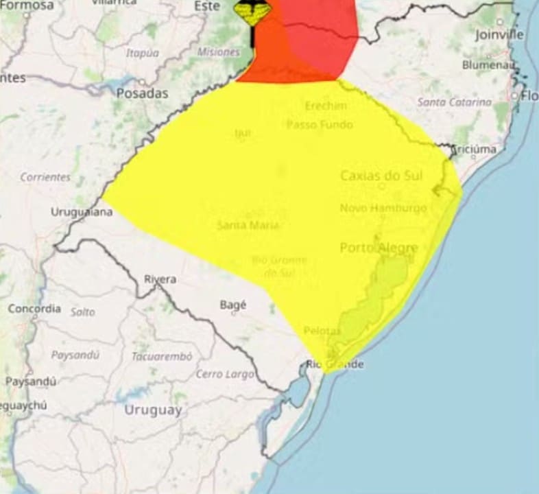
Fenômenos drives instability and humidity in the state
The formation of a new extratropical cyclone over the ocean, near the Uruguayan coast, and the simultaneous advance of a cold front contribute to the configuration of an adverse meteorological situation in Rio Grande and Sul. Esses atmospheric systems work together to organize rain clouds. Essa combination is responsible for significantly increasing instability over vast areas. The influence of these phenomena extends throughout much of the week, as meteorological models indicate.
The cold front, when moving over the ocean, helps to intensify the convergence of moisture over the continent, acting as a trigger for the formation of heavy clouds. The cyclone, in turn, organizes the system and increases the intensity of rainfall. Essa synergy between the two meteorological phenomena causes the expansion of precipitation areas, which become more frequent and voluminous compared to the normal pattern for this time of year. A considerable volume of water is expected in a short period.
The occurrence of these systems is common in the Sul region of Brasil, especially during periods of season transition. However, the way they are organized now suggests an event with the potential to generate more significant impacts. Coastal communities and areas close to the border with Uruguai are the first to feel the direct effects of this intense atmospheric movement.
Rajadas of wind and warning for heavy rain
Além of the significant increase in the volume of rain, the meteorological scenario also indicates the occurrence of gusts of wind. Essas gusts may reach moderate intensity in several regions of the state. The strongest winds are expected for regions Sul, Leste and throughout Litoral of Rio Grande of Sul. It is essential that the population in these areas remains alert to possible falling trees and interruptions in the electricity supply.
Instituto Nacional of Meteorologia (Inmet) has issued a warning of potential danger of heavy rain, which remains valid until the end of this Tuesday. Este specific alert covers a vast portion of the state of Rio Grande do Sul, indicating the possibility of significant volumes of precipitation and associated risks. The population must be aware of the areas at greatest risk and safety recommendations.
Regions covered by Inmet’s warning of potential danger from heavy rainfall include:
- Noroeste Rio-grandense
- Centro Ocidental Rio-grandense
- Sudoeste Rio-grandense
- Metropolitana from Porto Alegre
- Sudeste Rio-grandense
- Nordeste Rio-grandense
- Centro Oriental Rio-grandense
Este type of alert indicates that there is a risk of electricity cuts, falling tree branches and occasional flooding. Authorities recommend caution and that residents avoid traveling through risk areas. Attention must be constant, especially in places known for water accumulation.
Cenário for the coming days: persistence and intensification
Climatic instability in Rio Grande and Sul is expected to persist in the coming days, although with some variations in the intensity and distribution of rain. On Wednesday (22), the Climatempo forecast indicates that the strength of rainfall may reduce in part of the Rio Grande do Sul territory. Isso means that while some areas may see temporary relief, others will still face adverse conditions.
Ainda therefore, even with the reduction in general intensity, isolated rain showers are forecast. Essas specific occurrences will be more likely and concentrated in some specific locations, such as the state’s Oeste and Região of Campanha. Nestas areas, the population should remain alert to the possibility of locally high volumes, which could cause disruption despite the apparent improvement in the weather elsewhere.
The meteorological situation, however, will worsen again on Thursday (23), according to meteorologists. A further increase in the flow of moisture over the state is expected, which will contribute to the resumption of increased instability. Esse atmospheric movement is crucial for the intensification of rain in different areas of Rio Grande and Sul, reversing the brief respite observed the previous day. Será a day of renewed alert for many cities.
Recomendações and expected impacts on the population
Diante of the instability situation and meteorological alerts, the authorities recommend that the population of Rio Grande do Sul adopt preventive measures to minimize the risks. It is essential to follow the bulletins from Defesa Civil and meteorological agencies. Paying attention to hillside areas and regions prone to flooding is vital, avoiding staying in risky locations during the most intense rains.
Potential impacts from rain and wind include disruption to basic services such as electricity supply and water supply. Também there is a risk of landslides in hillside regions, especially in urban areas with irregular occupation. Defesa Civil can issue specific recommendations by municipality. Essas recommendations must be followed strictly.
In case of emergency, the advice is to contact numbers 190 (Brigada Militar), 193 (Corpo of Bombeiros) or Defesa Civil of the municipality. It is also important to avoid traveling through flooded streets or risky areas, as the force of the water can be treacherous. Prevention is the best way to protect lives and material assets.
Drivers, in particular, should pay extra attention when driving in rain and wind, maintaining a safe distance from other vehicles. Visibility may be significantly reduced. The population should, therefore, plan their travel and, if possible, avoid non-essential trips on the most critical days. Everyone’s safety must be the priority.
