

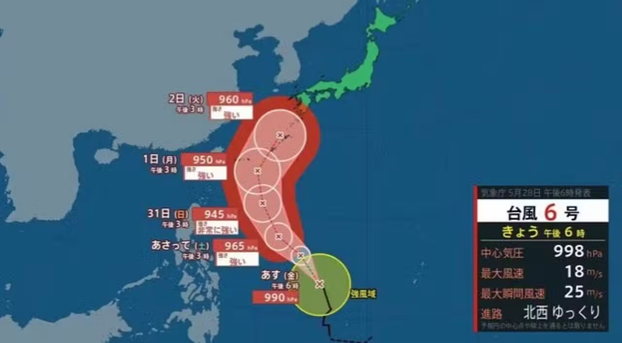
Agência Meteorológica of Japão has issued a stern warning about the approach of Tufão No. 6, officially named Chan-mi, which is advancing towards the country’s southern islands. The weather system is expected to hit the Okinawa and Amami regions between June 1st and 2nd, bringing destructive winds and torrential rain. Especialistas predict that the phenomenon will reach a central pressure of 945 hectopascals in the next few hours. Essa rapid intensification turns the storm into an imminent threat to coastal infrastructure and the safety of residents. Local authorities have already started prevention protocols and are monitoring the storm’s trajectory minute by minute. The scenario requires maximum attention due to the risk of high tides and landslides in the most vulnerable areas.
Evolução of the tropical system and trajectory towards Japanese territory
Atualmente classified as the sixth major tropical system of the season, typhoon Chan-mi is undergoing an accelerated strengthening process over ocean waters. The phenomenon began to take shape east of Filipinas, where it found ideal atmospheric conditions for its expansion. The initial movement occurs slowly, which allows the system to absorb more moisture and energy before accelerating. The official projection indicates a continuous shift to the northwest during the first days of formation. Logo then the route is expected to tilt to the north-northwest, placing the Japanese archipelago directly in the line of impact.
The dynamics of tropical cyclones at this time of year require rigorous monitoring, and mathematical models converge towards a dangerous approach to the southern islands. Pequenas variations in sea surface temperature can alter the storm’s speed. Therefore, meteorologists maintain an uninterrupted observation regime using high-resolution satellites. The estimate indicates that the peak intensity will occur on May 31, shortly before reaching Japanese maritime space. The population residing in risk areas follows official bulletins, knowing that the response time decreases with each kilometer advanced by the cyclone. The continued strengthening of the storm’s core poses a logistical challenge for civil defense teams.
Dados current weather and extreme wind projections
The latest records provided by Agência Meteorológica from Japão detail the current magnitude of the weather event. Durante on the afternoon of the 28th, the low pressure center was stationed east of Philippine territory. The central pressure measured by the instruments was 998 hectopascals, a number that will drop drastically as the system organizes itself. Sustained wind speeds near the eye of the storm reached 18 meters per second. The instantaneous gusts already reached the mark of 25 meters per second, demonstrating the latent strength of the phenomenon even before its maturation.
- Geographic Posição registered on the 28th: Leste from the Filipinas archipelago.
- Atmospheric Pressão at storm core: 998 hectopascals.
- Velocidade of sustained winds near the center: 18 meters per second.
- Pico of observed instantaneous gusts: 25 meters per second.
- Direção of current displacement: Movimento slow to the northwest sector.
The experts’ greatest concern lies in the forecast that central pressure will plummet to 945 hectopascals. A drop of this magnitude indicates an extremely dangerous category storm. With this configuration, wind gusts can reach an impressive 60 meters per second when the system reaches Okinawa. Essa wind power has sufficient capacity to cause severe structural damage, knock down large trees and destroy electricity transmission networks. Designed speeds require buildings to be inspected and secured. The combination of intense winds and the abrupt drop in atmospheric pressure creates a high-risk environment for anyone who is unprotected outdoors.
Severe Impactos on the coast of Amami and risk of flooding
The coastal communities of Okinawa and Amami face imminent danger of significant marine unrest. Tufão Chan-mi’s approach generates high waves that travel long distances before reaching the coast. Commercial shipping and artisanal fishing receive continuous alerts from port authorities. Smaller Embarcações need to be removed from the water and anchored in safe locations inland. The rough sea also brings the phenomenon of storm surge, which worries urban managers. The cyclone’s low pressure raises sea levels and pushes a large volume of water into coastal cities.
The volume of precipitation associated with the typhoon’s cloud bands raises the alarm for land disasters. Torrential rains are expected to hit the region continuously, saturating the soil quickly. Sistemas urban drainage systems tend to operate at the limit of their capacity due to the massive amount of water expected in a short period of time. Nas areas with irregular topography, the weight of water accumulated on the slopes increases the risk of landslides. Bairros built near hills and valleys are at risk of flash floods and debris flows. Crisis management focuses on mapping these zones to ensure the safety of residents during the height of the storm.
Protocolos security and civil defense mobilization
The imminence of a severe climate event requires a coordinated response between the government and the population. Agência Meteorológica of Japão reinforces the need for advance preparation, warning that planning must be completed before the strongest winds arrive. Moradores from threatened provinces receive instructions through official channels and local broadcasters. The main guidance involves assembling emergency kits containing drinking water, non-perishable food, basic medicines, flashlights and extra batteries. Evacuation routes are being reviewed and public shelters are on standby to receive families living in risk areas.
The local infrastructure is also undergoing adaptations to ensure the functioning of essential services. Electricity companies position maintenance teams at strategic points, ready to act as soon as weather conditions allow safe work on the streets. The local government asks the population to avoid unnecessary travel and not to approach rivers, canals or beaches under any circumstances. Community cooperation plays a key role in mitigating damage by facilitating rapid reporting of incidents to authorities. Monitoring of atmospheric conditions will continue uninterruptedly until the climate system completely moves away from the archipelago and no longer poses a direct threat to the region.