
The third winter storm in a week dumps snow on parts of the central Estados Unidos. The system moves northeast and rapidly intensifies into a bomb cyclone on Tuesday, December 2. Cidades like Filadélfia, Nova York and Boston record flakes in the morning but avoid significant accumulations.
The phenomenon occurs due to a pressure drop of at least 24 millibars in 24 hours. Ventos gain strength off the coast of New England at night. Alertas of winter weather affects almost 70 million people from Planícies to Maine.
- Snow continues into Vale from Ohio and expands eastward.
- Freezing rain falls from central Arkansas to southeast Missouri.
- Rain intensity increases in Golfo, from Nova Orleans to Panhandle to Flórida.
Current situation in the Midwest
Snow persists at Chicago, St. Louis and Indianapolis on the evening of Monday, December 1st. Acumulações ends in Iowa and Kansas. Controladores issue ground stop at Aeroporto Internacional O’Hare from Chicago just before 8pm CT for snow and ice.
The stop lasts one hour and interrupts all flights. Kansas City records 3.6 inches of snow at the international airport, breaking the daily record for December 1st. The previous benchmark was 1.5 inches 40 years ago.
Storm trajectory
The system organizes overnight and spreads snow, rain and icy mix further east. Neve arrives in the northeast on the morning of Tuesday, December 2nd. Áreas interiors face impacts on morning traffic in Pittsburgh, Albany and Buffalo.
Cities on the I-95 corridor avoid heavy snow, but inland areas accumulate greater amounts. Ventos gustam on the coast of New England on Tuesday night.
Records of impending cold
Temperatures drop further east of Montanhas Rochosas after the storm passes. Ar Arctic invades the center and east at the end of the week. Mínimas flirt with daily records on Thursday and Friday in the Planícies, central west and interior northeast.
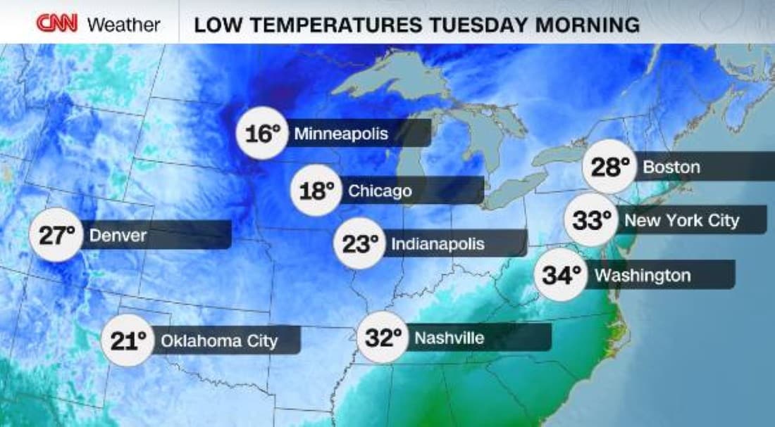
From Denver to Boston, thermometers record lows on Tuesday morning. Intense Ventos reduce thermal sensation significantly.
Effects on air transport
Ground stop affects O’Hare at Chicago on the evening of December 1. Voos face delays and cancellations at Midwest airports. Sistema heads towards Atlântico Canadá after impact in the northeast.
Snow and ice cause slips on trails. Autoridades monitor conditions at main terminals.
Accumulations in the Midwest
Kansas City surpasses the mark with 3.6 inches on December 1st. Outras areas in Missouri and Kansas are reporting between 2 and 4 inches. Bandas heaviest are concentrated to the north of the metropolitan region.
- Basehor: 4 inches.
- Lansing: 4 inches.
- Shawnee: 3.8 inches.
Forecast for the northeast
Widespread snow marks the first of the season in parts of the Northeast on Tuesday. Áreas mountainous areas accumulate more. Ventos strong accompanies the bomb cyclone on the coast.
Coastal cities see isolated flakes in the morning. Interior records significant layers affecting highways.
Expected temperatures
Lows on the morning of December 2 vary depending on location. Denver records low values. Boston faces severe cold with winds.
Thermal sensation drops due to gusts from the intensifying system. Ar colder follows the storm.
Alerts in effect
Nearly 70 million under winter warnings from Oklahoma to Nova York. Avisos of winter storms in parts of the northeast and Michigan west. Condições require caution when traveling.
Snow expands through Vale from Ohio during the night. Chuva freezing persists in specific areas.
