The Serviço Nacional of Meteorologia of the Estados Unidos has issued a flood warning for the northwest of Oregon and the southwest of maximum of the authorities and the local population. Este scenario, with soils already saturated by previous rains, significantly increases the risk of overflows and flooding, generating concern in several communities.
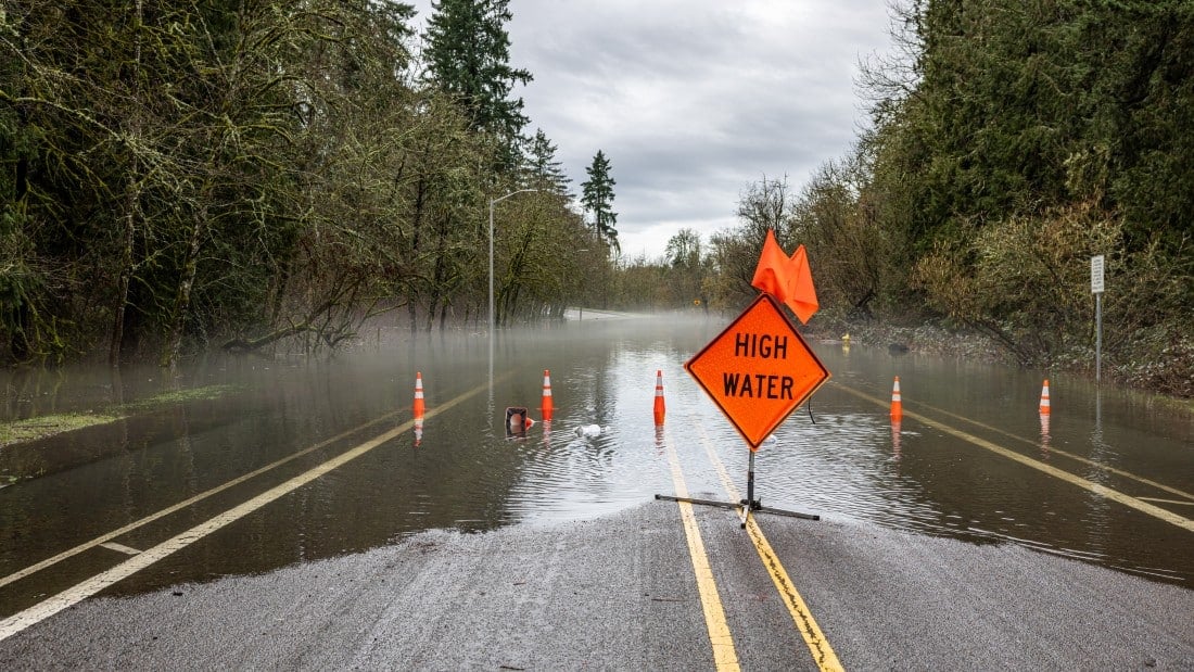
Residents near rivers and roads prone to flooding are being advised to avoid unnecessary travel. Mesmo just a few centimeters of water on roads can pose significant dangers, as data from the meteorological service warn, hiding damage or strong currents.
The authorities reinforce the importance of following the following guidelines:
– Evite drive in flooded areas, as the depth and current are unpredictable.
– Monitore official updates constantly through reliable communication channels.
– Prepare evacuation plans if necessary, especially for those in high-risk areas.
Preventive measures and safety recommendations
Early preparation can make a difference in everyone’s safety, minimizing risks during the period of greatest rain intensity. Communities are being mobilized to adopt precautions to protect lives and properties.
Guidance includes reviewing residential drainage systems, protecting important documents and ensuring pets are safe. Collaboration between neighbors to help the elderly and people with reduced mobility is also encouraged.
Rivers under surveillance for critical elevation in 2025
Several rivers in the alert coverage area are forecast to see a significant increase in their levels in the coming hours, a scenario that is repeated in intense weather events in the region. The Clackamas river, for example, is one of the most critical, expected to reach moderate to major flooding stages in the vicinity of Oregon City and Estacada by Friday morning, which requires maximum attention.
Forecast models indicate that the river could reach notable peaks due to the volume of rain that is expected to accumulate, exceeding the absorption capacity of the already saturated soil. Isso increases the risk of overflows in inhabited and agricultural areas.
The Johnson Creek is also on the list of watercourses under special monitoring, with the possibility of major flooding expected to begin this Thursday night. Outros rivers, such as the Sandy River and Molalla River, are expected to experience minor flooding from Friday morning, requiring continued attention from riverside communities.
Details of the current meteorological phenomenon
An atmospheric river persists over the region, bringing with it periods of moderate to intense rain to the northwest of Oregon and the southwest of Washington throughout this Thursday and continuing. Precipitation accumulations can vary between 50 and 100 millimeters in areas of Vale, Willamette and in the vicinity of Portland, with even higher peaks in isolated points. Este volume of water represents a considerable challenge for drainage systems and natural runoff capacity.
The condition of the soil, already soaked by previous rainfall events, facilitates rapid surface runoff of water into rivers and streams, instead of allowing infiltration. Pequenos streams and urban drainage systems are the first to respond to rain, increasing the initial risk of localized flooding in streets, avenues and low-lying areas.
Authorities’ preparation strategies
Local authorities are actively involved in implementing preventive measures to mitigate the impacts of flooding, seeking to protect the population and infrastructure. Pontos sandbag distribution facilities have been established in vulnerable areas, such as at several fire stations in Condado of Clackamas, to assist residents in protecting their properties from rising waters.
Residents near the rivers Clackamas and Sandy are being encouraged to reinforce their protective barriers and be vigilant for any changes in water levels. Equipes emergency services maintain uninterrupted monitoring of river and stream levels, ready to act quickly in the event of an emergency.
Main rivers under constant observation
Meteorological authorities maintain special surveillance over several rivers in the region, due to the high risk of their levels rising. The list below details some of the main watercourses monitored:
– Clackamas River: Previsão moderate to major flooding.
– Johnson Creek: Risco of major flooding.
– Sandy River: Inundação lowest predicted.
– Molalla River: Inundação smaller in the vicinity of Canby.
– Pudding River: Monitoramento continuous due to potential elevation.
– Nehalem River: Possibilidade of overflow.
– Wilson River: Alerta flood extended.
– Siletz River: Aviso elevation in effect.
– South Yamhill River: Elevação of expected levels.
– Luckiamute River: Observação continuous.
Dangers and challenges posed by floods
Flooding poses significant risks to the safety of drivers and pedestrians across the region, requiring extreme caution. Apenas 15 centimeters of fast-moving water has enough force to knock over an adult, while 30 centimeters can sweep away most vehicles, turning roads into dangerous traps. Estradas that appear safe but are submerged often hide open ditches, deep holes or structural damage that is not visible, making crossing extremely risky.
Current situation and prospects for rivers
Despite forecasts, as of Thursday afternoon, no river in the region was at a major flood stage, indicating that preventive measures and monitoring are being effective in containing the immediate impacts. Inundações minors were recorded in isolated points, but the main peak in river levels is expected to occur between Thursday night and Friday morning, the period of greatest attention. The Cowlitz River, located in Washington, is a particular concern for residents due to the accumulation of sediment from past events, which can worsen runoff and flow capacity.
Crucial safety guidelines for residents
Authorities reinforce the importance of all residents, especially those living in areas historically prone to flooding, having well-defined and up-to-date emergency plans. It is essential to constantly monitor official communication channels, such as the Serviço Nacional of Meteorologia website, to obtain the latest, real-time updates on the climate and river situation, ensuring informed decisions.
Rescue teams and emergency services are on high alert and prepared to respond to events related to flooding and possible rescues. Maintaining emergency kits, containing basic supplies such as drinking water, non-perishable food, flashlights and a battery-powered radio, is an essential preventive measure that can help families in situations of temporary isolation.
Atmospheric system dynamics and impacts
The atmospheric river maintains its intensity throughout this Thursday, with the heaviest rain concentrated during the afternoon and night, according to meteorological models. The expectation is for a gradual reduction in the intensity of precipitation from Friday onwards, although traces of humidity may still persist until Saturday, prolonging the state of alert in some areas. The mild temperatures prevailing in the region prevent the occurrence of snow at low altitudes, ensuring that all precipitation manifests itself as rain, directly contributing to the volume of water in rivers and the risk of overflows.
Cities like Portland and Vancouver are feeling direct impacts on urban traffic, with congested roads and flooding points that make mobility and movement difficult. The current climate event follows a pattern of similar systems that have recently been observed in the Pacífico Noroeste region, indicating a trend towards more intense events.
Potential effects on regional infrastructure
Predicted flooding has the potential to significantly affect road infrastructure, including major highways and secondary roads in counties such as Clackamas, Multnomah and Washington, and could cause prolonged outages. Equipes maintenance staff are working preventatively to clean manholes and drainage systems to try to reduce the accumulation of water on streets and roads, a crucial action to minimize damage.
Rural communities located near smaller rivers face the possibility of temporary isolation due to blocked roads and bridges, requiring contingency plans to ensure access to essential services. Pontes of low height, which are more susceptible to being submerged, receive special monitoring to ensure the safety and integrity of their structure, preventing accidents and collapses.
