
Residents of several Texas counties, including the regions of Houston and The weather forecast indicates the concrete possibility of extreme phenomena until 9pm, requiring immediate caution from anyone traveling through the area or planning nighttime activities. The safety of the population depends on the rapid response to warnings issued by the competent authorities.
A line of storms progressively moves from west to east, creating a scenario ripe for the rapid development of severe weather cells that could surprise local communities. Especialistas monitor the situation in real time, warning that the danger window covers the night period, coinciding precisely with the celebrations of commemorative dates in the region. Surveillance must be constant until the system loses strength.
The main hazards associated with this climate disruption include risks that can cause significant property and physical damage. Entre The threats monitored include:
– Rajadas of violent winds that can exceed the 120 km/h mark, with enough force to knock down trees and power lines;
– Queda of hail with a diameter comparable to table tennis balls, posing a risk to vehicles and roofs;
– Potencial for the formation of isolated tornadoes at specific points on the squall line.
Despite the seriousness of the warning, official guidance does not require the total cancellation of plans for the night, as long as precautionary measures are strictly followed. The public was advised to stay informed and be ready to seek shelter immediately if weather conditions deteriorate before the warning is expected to end.
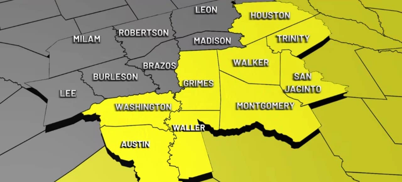
Affected areas and scope of the phenomenon
The emergency notification covers a vast territorial extension in Vale to Brazos, directly impacting the routine of thousands of citizens. Condados like Washington, Walker, Trinity, Austin, Waller, The geographical scope of the alert demonstrates the need for a coordinated response between emergency services and residents of these locations.
The advisory, which came into force early in the evening, highlights that the most critical threat is concentrated along the line of storms and in the moments immediately preceding it. Esta characteristic is typical of convective systems in the Texas, where the change in weather can occur abruptly, reducing reaction time for those outdoors or in traffic.
Safety and preparedness protocols
Faced with the real possibility of tornadoes and windstorms, individual and family preparation becomes the main defense tool. It is essential that each residence has an emergency plan established, identifying the safest place in the house. Cômodos ground-floor interiors, such as bathrooms, utility rooms, or windowless central hallways, offer the best protection against flying debris and structural collapse.
Assembling an emergency kit is another essential measure to face possible interruptions to basic services. Este kit must contain essential items such as flashlights with new batteries, portable radio, drinking water, non-perishable food and continuous use medicines. Ter these affordable materials can make all the difference during and immediately after the storm passes.
To ensure receipt of notices, it is recommended to have multiple sources of information active. Além alerts on smartphones, the use of NOAA meteorological radios and monitoring of local broadcasters ensure that information reaches even if there are failures in the telephone or internet network.
Understanding the destructive potential
The intensity of the forecast winds, exceeding 120 km/h, has considerable destructive capacity, potentially transforming loose objects in backyards and balconies into dangerous projectiles. Estruturas more fragile buildings, such as sheds and outdoor garages, are particularly vulnerable to these gusts, requiring homeowners to secure their assets in advance.
The large hail predicted to accompany the storms poses an economic and physical risk. Pedras ice the size of ping-pong balls can break windshields, damage car bodywork and destroy roofs. Para local agriculture, this type of solid precipitation can result in severe losses in exposed crops.
Tornadoes, even when isolated, are phenomena of extreme violence and unpredictability. The formation of these rotating air columns requires immediate action, as their trajectory can change quickly, reaching areas that minutes before seemed safe. Texas, located in a region geographically prone to these events, has a history that reinforces the importance of never underestimating a tornado warning.
Future weather outlook
Analysis of meteorological models indicates that the storm system should progressively dissipate after 9 pm, bringing gradual relief to the Vale region of Brazos. The tendency is for instability to give way to a calmer atmosphere as the front advances out of the risk area.
For the following Sunday, the forecast is optimistic, pointing to a day of dry weather and predominantly clear skies. Essa radical change in weather conditions will allow communities to safely assess any damage and resume normal activities after the tense night.
