

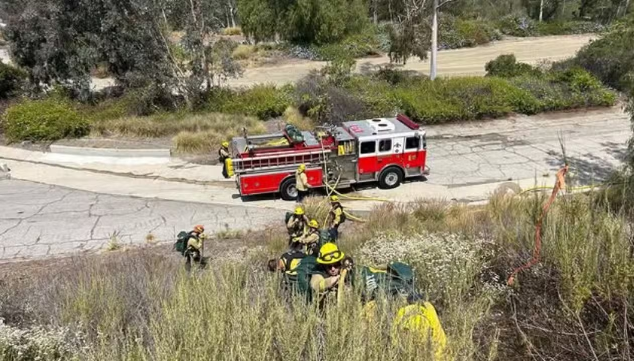
On June 10, 2025, at approximately 3:45 PM, the Burbank Fire Department responded to a brush fire near the intersection of Amherst Drive and Bethany Road in Burbank, California. Named the “Bethany Fire,” the blaze, initially spanning about half an acre, poses no immediate threat to structures, and no evacuation orders have been issued. Authorities have closed all hiking trails in the Burbank hills, including popular recreational areas like Wildwood Canyon and Stough Nature Center, to ensure public safety. The rapid response, involving ground crews and water-dropping helicopters, aims to contain the fire amid dry vegetation and conditions conducive to rapid spread. Residents are urged to monitor updates via the city’s official Ready Burbank website.
The operation escalated quickly, with two helicopters and an additional response team deployed to reinforce containment efforts. Burbank police are assisting in the area, guiding people away from trails and ensuring no one remains in at-risk zones. The closure of recreational areas reflects heightened caution, as the combination of dry brush, warm temperatures, and moderate winds elevates fire risks. For real-time updates, the city directs residents to readyburbank.org, a centralized platform for emergency information.
- Affected areas: Hiking trails in Burbank hills, including Wildwood Canyon and Stough Nature Center.
- Safety measures: Complete trail closures and police assistance for visitor evacuation.
- Official updates: Available through Ready Burbank (readyburbank.org).
- Fire status: No structural threats or evacuations reported at this time.
Swift action by firefighters
The Burbank Fire Department received the call at 3:21 PM, as reported via PulsePoint, a platform tracking emergency incidents. The fire’s initial half-acre footprint prompted the deployment of ground crews and aerial support, with two helicopters requested for water drops. The strategy focused on preventing flames from reaching nearby residential areas along Amherst Drive and Bethany Road.
While the fire is partially contained, crews remain vigilant for potential flare-ups. The region’s dry vegetation, typical for this time of year, poses an ongoing challenge, as small embers can reignite quickly. Favorable wind conditions have aided efforts, but firefighters continue to monitor the weather closely.
Police support has been critical, with officers patrolling trails to ensure compliance with closure orders. The decision to shut down recreational areas stems from California’s history of fast-spreading wildfires and the need to minimize public exposure to danger.
Recreational areas locked down
Burbank’s hills, renowned for scenic trails and panoramic views, draw hikers and nature enthusiasts year-round. The Bethany Fire, however, forced the immediate closure of key sites like Wildwood Canyon and Stough Nature Center. These restrictions aim to protect visitors and provide unimpeded access for emergency crews navigating the rugged terrain.
The closures will remain in effect until authorities deem the area safe. Dense vegetation and steep slopes complicate firefighting efforts, requiring sustained monitoring even after initial containment. Visitors present during the incident were promptly escorted out by police, ensuring no one was left in harm’s way.
California’s fire-prone landscape
California’s wildfire season is a perennial challenge, driven by climate change, prolonged droughts, and highly flammable vegetation. In 2025, updated fire hazard maps from CAL FIRE classified Burbank as a high-severity zone, necessitating stringent prevention measures. These include clearing dry brush and maintaining defensible spaces around properties.
The Burbank Fire Department has ramped up its Fire Hazard Reduction Program, urging residents to comply with vegetation management guidelines. The updated hazard maps, finalized in March 2025, underscore the need for proactive measures in both urban and rural communities.
- Risk factors: Dry vegetation, high temperatures, and seasonal winds.
- Prevention efforts: Vegetation clearance programs and community awareness campaigns.
- High-risk zones: Burbank listed as a high-severity area by CAL FIRE.
Community engagement
Beyond the emergency response, Burbank’s residents have been called to stay informed and vigilant. The Ready Burbank website serves as a hub for real-time updates, offering guidance on safety protocols and emergency alerts.
Residents near the affected areas were advised to steer clear of the hills and report any suspicious activity, such as new fire outbreaks. This collaborative effort between firefighters, police, and the community is vital to preventing escalation.
Burbank’s fire history
Burbank has faced similar incidents before, notably a 2017 fire above Hamline Place that triggered evacuations. That event required support from the Los Angeles Fire Department’s helicopters. While the Bethany Fire is less severe so far, it highlights the ongoing need for preparedness in a city surrounded by fire-prone vegetation.
The nearby Sepulveda Basin, another high-risk area, saw a 75-acre fire in August 2024, contained without significant damage. These incidents reinforce the seasonal threats Burbank faces.
Enhanced safety protocols
To curb fire spread, the Burbank Fire Department enforces strict protocols during wildfire season. Regular inspections ensure compliance with vegetation clearance rules, with key measures including:
- Annual inspections: Properties in high-severity zones are checked yearly.
- Non-compliance penalties: Fines for failure to clear dry brush.
- Community education: Campaigns to raise fire safety awareness.
- CAL FIRE collaboration: Joint efforts to update risk maps.
These measures are bolstered by ongoing firefighter training for challenging terrains and adverse weather conditions.
Real-time monitoring
Residents are encouraged to use PulsePoint for live updates on the Bethany Fire. The app provides details on the fire’s location, size, and response actions. Authorities also advise preparing for potential shifts, such as evacuation alerts if flames approach residential zones. For now, the lack of structural threats keeps the focus on containment and trail safety.
Future preparedness
Burbank’s wildfire season demands continuous prevention and readiness. The Fire Department plans community meetings to review updated risk maps and vegetation clearance programs. A Fire Service Day event, scheduled for May 2025, will bring together residents and officials to promote fire safety awareness.
The city also leverages satellite-based mapping to pinpoint vulnerable areas, enhancing its ability to respond swiftly. These tools, combined with robust emergency response, are critical to mitigating incidents like the Bethany Fire.