

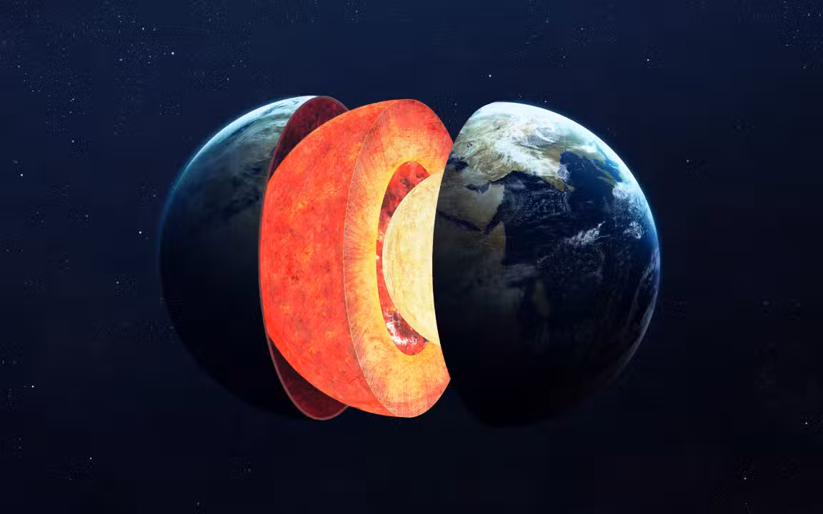
A group of scientists managed to map the deepest region inside Terra with an unprecedented level of detail. The research identified clear anomalies and structural deformations in the lower part of the Earth’s mantle. The phenomenon occurs due to the presence of ancient tectonic plates. Essas structures sank millions of years ago. The rocky material slowly traveled from the surface to the vicinity of the planet’s core.
The discovery offers a new perspective on the internal dynamics of Terra. The study focused on the boundary between the core and the mantle. Essa layer is about 2,900 kilometers deep. Researchers used a massive volume of seismic data to track physical changes in rocks. The material suffers extreme pressure and heat in this region. The results directly affect theoretical models of the Earth’s magnetic field. Long-term geological evolution takes on new contours with this newly cataloged physical evidence.

The path of rocks from the surface to the depths of the planet
The Earth’s crust is divided into large rigid blocks known as tectonic plates. Essas structures float on the mantle and constantly collide. One plate may slide under another during this process. The movement is called subduction. The rocky matter then begins a long journey towards the center of the planet. The geological process works like a gigantic conveyor belt. Rocks carry specific characteristics acquired at the surface. The deep environment preserves some of this original chemical signature. The friction generated in this colossal dive releases immense amounts of energy. Seismographs capture this activity daily.
The intense heat and crushing force of the lower mantle alter the mineral composition of the material. Transit time lasts millions of years. The interaction between the descending plate and the surrounding matter continually reshapes the deep environment. The mantle undergoes constant compression. Novas flow directions emerge in the region. An Universidade team from Maryland led the investigation into these changes. Scientists have observed the direct impact of these rocks on the global structure of the planet. The three-dimensional mapping required a massive computational effort on the part of the experts involved in the project.
Análise of seismic waves reveals anomalies in the lower mantle
The study methodology was based on detailed analysis of waves generated by earthquakes around the world. The tremors transmit energy through the interior of the Terra. The speed and direction of these waves change as they encounter different materials. The variation works like an ultrasound scan of the planet. The behavior of waves records the exact moment they cross different layers. Scientists have compiled the globe’s largest physics database ever assembled for this purpose. The precision of modern instruments made it possible to capture nuances that were previously invisible.
Researcher Jonathan Wolf coordinated the analysis of the information. The team examined the fundamental need to accurately map the globe. The work required advanced algorithms to process the volume of records. The research confirmed long-held theories about the deformation of the upper mantle. The new focus targeted the lower layer and its historical gaps. The initial integrated vision surprised experts. The raw data went through months of rigorous filtering.
- The volume of seismic records analyzed exceeded the mark of 1.6 million global events.
- Data coverage reached approximately 75% of the entire extent of the lower mantle.
- Geological anomalies appeared in two-thirds of the total area investigated by scientists.
- The most obvious patterns coincided exactly with ancient plate subduction zones.
- The scientific journal The Seismic Record published the full results of the investigation this week.
The publication of the article represents an important milestone for the international geophysical community. The data catalog provides a solid foundation for future investigations. Researchers applied complex mathematical techniques to decipher signals picked up by thousands of monitoring stations. Background noise needed to be filtered rigorously. The precision of the calculations made it possible to identify blocks of rock hundreds of kilometers long. The mapping revealed a rich and diverse underground topography. The deep structures feature inverted valleys and mountains of continental proportions.
Impacto directs understanding of geological evolution
Scientists seek to explain the exact origin of the anomalies found in the depths. Duas leading theories gained traction with the new data. The first hypothesis suggests the preservation of a unique chemical signature. Plate tectonics would maintain surface elements even after extreme diving. The second line of reasoning points to violent physical deformation. The impact of the rocky material against the dense core would generate the observed irregularities. Extreme contact alters the crystalline structure of minerals. The pressure crushes the molecules and irreversibly rearranges their atomic bonds.
The Earth’s mantle maintains a constant movement driven by thermal convection currents. Heat from the core rises toward the crust. Cold material from the surface descends along the same path. The cycle lasts hundreds of millions of years. The continuous mechanism moves continents and fuels volcanic activity. The formation of large mountain ranges depends on these internal dynamics. The occurrence of devastating earthquakes also has roots in this deep process. The new geological map provides crucial clues about the mechanics of these large-scale events. Geophysicists now have better tools to understand the behavior of global tectonic faults.
Próximos steps to uncover the interior of Terra
Understanding deep deformation processes requires increasingly sophisticated computational models. The flow of the lower mantle dictates the rules of long-term geological evolution. Current research lays a robust foundation for the next steps in science. Experts plan to refine the spatial resolution of seismic images. The objective involves mapping underground currents with millimeter precision. The integration of these data with climate and magnetic models appears as a real possibility. The magnetic field protects life on the surface from harmful solar radiation.
The database built by Universidade’s Universidade team will serve as a valuable resource for laboratories around the world. Exploring the interior of Terra shares similarities with investigating outer space. Technical challenges require constant innovation in information processing. Continuous improvement of seismic analysis algorithms remains an absolute priority. The planet continues to reveal its oldest secrets through the mathematical decoding of the shock waves that pass through its deepest layers. Modern geology enters a phase of accelerated discoveries driven by data technology.