Minas Gerais Observatory tracks manned capsule from Artemis II mission towards lunar orbit
The observatory structure Sonear, located in the city of Caeté, in the metropolitan region of Belo Horizonte, was able to track and document the passage of capsule Orion during the execution of the current international space mission. The high-precision equipment operated by local experts accompanied the manned spacecraft on its journey towards deep space, obtaining photographic records when the vehicle was vast distances from planet Terra.
The monitoring work required dedication over several consecutive dawns to ensure the clarity of the captures amid the high speed of movement of the sidereal object. The operation demonstrates the technical capacity of astronomical facilities installed in the southern hemisphere to monitor events of global magnitude, using advanced light capture and motorized tracking systems.
The team of astronomers had to perform complex trajectory calculations to anticipate the ship’s exact position in the night sky, compensating for Earth’s rotation and the orbital movement of the capsule itself. The images obtained serve as an independent and fundamental record for monitoring the trip, providing visual data that complements official telemetry information.
Technical details of astronomical tracking on national soil
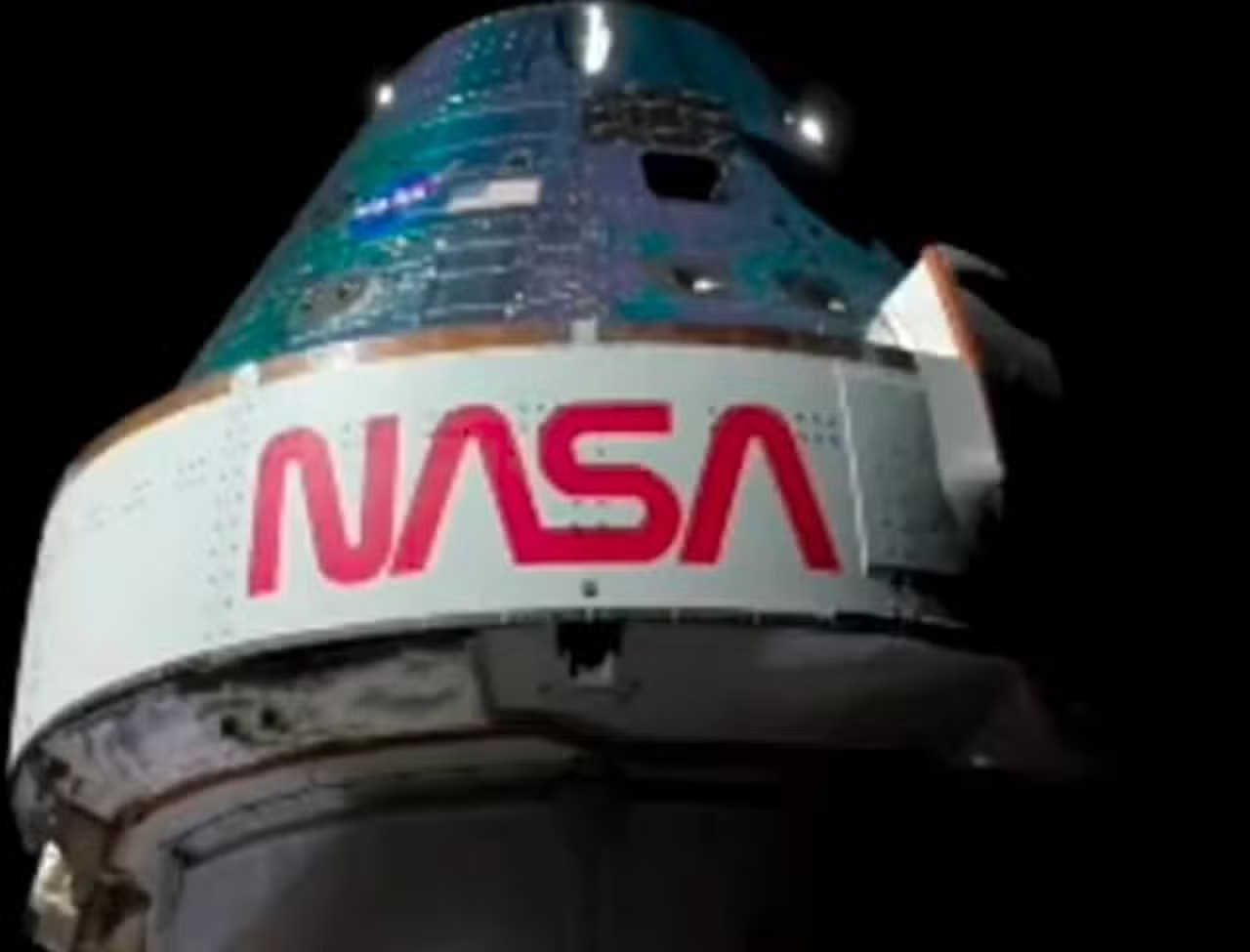
The team coordinated by engineer and astronomer Cristóvão Jacques began image capture work shortly after one of the main translunar injection orbital maneuvers. The first photograph confirmed by the group occurred when the spacecraft was positioned around 36,000 kilometers from the Earth’s surface, requiring a fine calibration of the telescope’s primary mirrors to avoid overexposure caused by the sun’s reflection on the vehicle’s metal fuselage.
As space travel advanced, professionals needed to continually recalibrate observation instruments to maintain focus on the increasingly distant target, adopting rigorous astrophotography protocols. The latest images validated by the Caeté team showed the capsule approaching the 400,000 kilometer mark, at which point visual documentation depended on the following operational factors:
– Sincronização absolute difference between the star mapping software and the telescope’s stepper motors.
– Ajuste exposure time dynamics of CCD cameras to capture scarce photons in deep space.
– Monitoramento real-time atmospheric conditions to avoid distortions caused by air currents at high altitude.
Importance of terrestrial infrastructure in data validation
The use of ground-based telescopes represents an additional layer of security and validation for international space agencies that coordinate human flights. Equipamentos independent companies can confirm trajectories and speeds without relying exclusively on telemetry data sent by the spacecraft’s onboard computers, creating a vital redundancy system for aerospace engineering. The ability to track an object the size of capsule Orion at hundreds of thousands of kilometers demonstrates the technological advancement of lenses and sensors currently available on the civilian and academic market. The Minas Gerais observatory used motorized tracking systems that autonomously compensate for the rotation of Terra to keep the target centered on the image sensor for hours on end. Esse This type of direct visual monitoring helps identify possible external anomalies, such as damage to the heat shield or failure to open solar panels, which the ship’s internal sensors might not detect immediately. Information redundancy strengthens the reliability of deep space operations by enabling mission control teams in Houston to make decisions based on multiple sources of visual and telemetric confirmation. Além Furthermore, the participation of globally distributed observation stations ensures that the spacecraft is monitored uninterruptedly, regardless of the planet’s rotation, eliminating blind spots in communication.
Resumption of manned travel and life support tests
The current flight marks the return of humans to the vicinity of Lua after a hiatus of more than five decades since the closure of the Apollo program. The spacecraft carries four crew members, including experts from the American space agency and a representative from the Canadian agency, forming an international coalition.
During the ten days of their scheduled journey, the astronauts carry out exhaustive tests on the life support systems of capsule Orion. The check ranges from air and water recycling to the efficiency of the protection panels against cosmic radiation, crucial elements for survival in deep space.
The trajectory chosen for this flight does not include a landing on the lunar surface, but rather a flyby that uses the gravity of the natural satellite to propel the vehicle back to Terra. Essa orbital maneuver, known as a free return trajectory, is essential to save fuel.


The data collected at this stage is vital for certifying the spacecraft for future missions, which envisage the establishment of a permanent operations base in lunar orbit. The success of this phase guarantees the technical feasibility of the next steps of interplanetary exploration.
Mechanical complexity in high-speed image capture
Photographing a fast-moving object in outer space requires perfect synchronization between the tracking software and the telescope’s steering motors. The capsule travels at thousands of kilometers per hour, which means that any miscalculation in motion compensation would result in a blurred image or complete loss of the target in the optical equipment’s field of view.
Operators had to continually adjust the cameras’ exposure parameters to deal with variations in light reflected by the ship’s fuselage. Conforme the angle in relation to Sol changed during the trip, the apparent brightness of the capsule Orion fluctuated drastically, requiring quick manual interventions to avoid losing the photographic frames.
Earth’s atmospheric conditions play a critical role in the success of long-range astronomical observations. The team needed to rely on nights with clear skies, without interference from dense clouds or excessive light pollution, which was favored by the altitude and relative isolation of the city of Caeté in relation to large urban centers.
Critical re-entry procedures into the Earth’s atmosphere
The final phase of the space operation involves critical re-entry procedures into the atmosphere, when the capsule’s heat shield faces temperatures exceeding two thousand degrees Celsius. Friction with the air at hypersonic speed generates a ball of plasma around the vehicle, temporarily interrupting radio communications with mission control.
The crew consisting of Reid Wiseman, Victor Glover, Christina Koch and Jeremy Hansen monitors internal systems as the vehicle progressively decelerates before the main parachutes open. The planning establishes that the landing will take place in the waters of the ocean Pacífico, where rescue teams are waiting on ships strategically positioned to lift the module.
Scientific contribution from South American institutions
The active participation of local astronomical complexes in monitoring events of global magnitude reinforces the technical capacity of South American professionals. The independent registration of high-profile missions inserts research institutions into a circuit of international scientific collaboration aimed at exploring the cosmos.
Historically focused on discovering asteroids close to Terra, the Sonear observatory has adapted its sky scanning routines to focus on an extremely important artificial object. Essa operational flexibility demonstrates the versatility of the installed equipment and the expertise accumulated by resident astronomers.
Technological advances driven by direct observation
The information consolidated from this manned flight and ground observations will serve as a basis for the construction of the next exploration modules. Engenheiros aerospace experts will use the generated database to improve the design of spacesuits, long-range communication systems and lunar descent vehicles, ensuring greater safety for future crews.
Visual monitoring as an operational redundancy tool
Continuous photographic recording of the trajectory of space vehicles by independent observatories creates a highly efficient global astronomical surveillance network. Quando telescopes on different continents follow the same object, it is possible to triangulate positions with extreme precision, identifying millimetric deviations from the planned route and correcting navigation anomalies.
This redundancy of observation ensures that, in the event of a failure in the ship’s communication systems, teams on the ground know exactly where the vehicle is and what its current speed is. The integration of high-level amateur and professional visual data creates a collaborative safety ecosystem that benefits the entire aerospace community.
Promotion of education and training of new researchers
Visual documentation of space missions has immeasurable historical and educational value, bringing the general public closer to the complexities of modern engineering and physics. By disseminating images captured from local installations, astronomical initiatives stimulate the population’s scientific curiosity and democratize access to information about the universe.
These practical actions stimulate the interest of new generations in careers in the areas of exact sciences, technology and astronomy. The success of the tracking demonstrates that participation in major humanity milestones can occur from well-equipped regional infrastructures operated by experts dedicated to continuous observation from space.
Veja Tambem em Latest News (EN)

Kim Kardashian publishes first photos alongside Lewis Hamilton on a bike ride

MSI Claw 8 EX AI+ is presented at Computex with Intel Arc G3 Extreme

Italy evaluates renewal of cut in fuel tax with gasoline at 2 euros per liter without discount

The Lone Gunmen celebrates 25 years as a spin-off of The X-Files with a comedic tone

PlayStation Plus Essential monthly games arrive in June with Grounded and Warhammer 40,000 Darktide

ROG Xbox Ally X20 Bundle arrives with translucent design and AR glasses for 20 years of ROG

Coronation Street dedicates episode to Alan Rothwell after original actor’s death

Preliminary agreement between Iran and the US is suspended after Israeli bombings in Lebanon

Alaskan Bush People star Matt Brown found dead in river at age 43 after disappearing

Nvidia announces Rtx Spark chip to reinvent the PC and challenge Intel and Apple

44-year-old man tries to abuse 5-year-old girl in Tyumen and is stopped by children in Russia