
Geometric formation on Mars recorded by satellites generates debate about geological origin

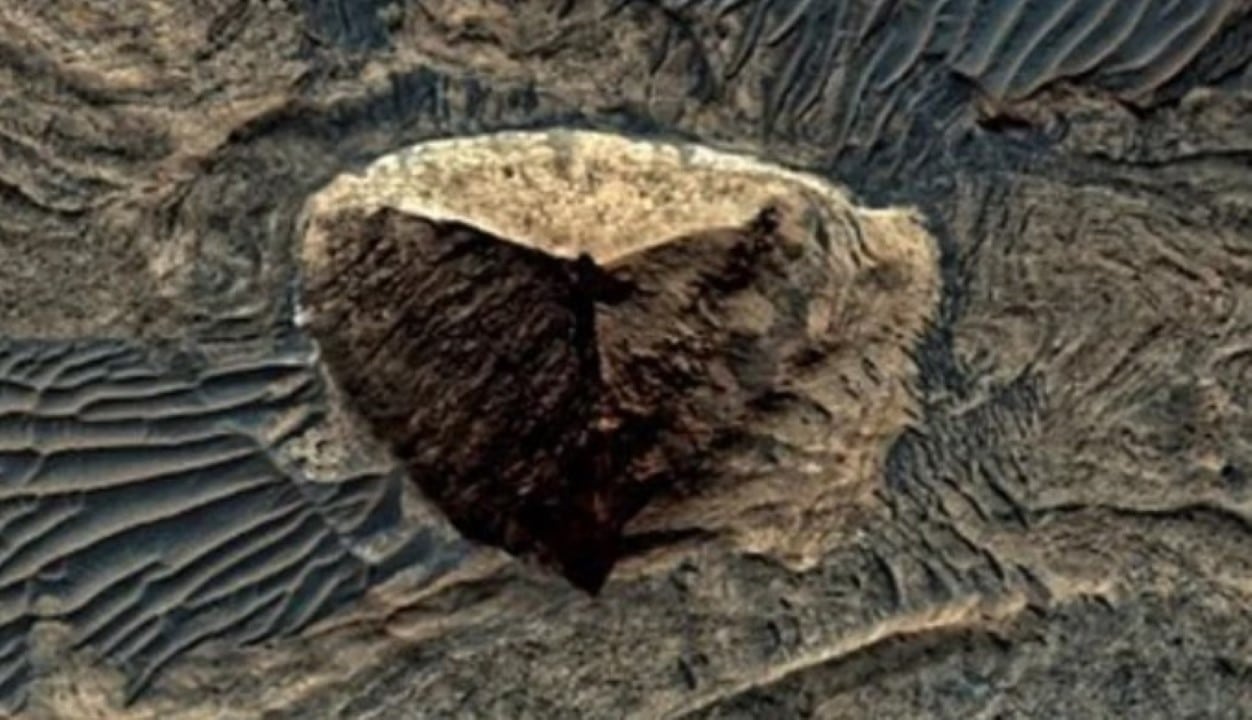
Registros photographs from orbital missions captured a rock formation with triangular outlines on the Martian surface. The geological structure has symmetrical faces and is located in the western region of Candor Chasma. The site is part of the vast canyon system known as Valles Marineris. The images generated discussions between astronomy enthusiasts and scientists about erosion processes on the neighboring planet.
The peculiar shape of the rock refers to the proportions of Grande Pirâmide and Gizé. Diferentes space probes documented the area on multiple occasions between 2001 and 2016. The consistency of the geometry under varying solar lighting conditions caught the attention of independent researchers. Especialistas in planetary geology point out that natural wear dynamics explain the appearance of the terrain.
Exact Geometria in Martian canyon intrigues independent researchers
The initial identification of the topographic anomaly occurred based on data sent by the Mars Global Surveyor probe. Analyst Keith Laney observed the angular patterns while reviewing public archives from the US space agency. Subsequent Fotografias confirmed the presence of the structure with defined edges and flat faces. The object stands out amidst a landscape composed predominantly of steep cliffs and irregular sediment deposits.
The sharing of these captures on digital platforms fueled debates about Marte’s story. Documentaristas like Brian Dobbs and George Haas questioned the likelihood of a natural formation achieving such a level of geometric precision. Eles suggest that the area would merit direct investigation by surface equipment. The absence of uneven erosion on one side of the rock serves as an argument for those who speculate about unnatural origins.
The Valles Marineris complex represents the second largest canyon system in the entire solar system. The colossal rift stretches for thousands of kilometers along the Martian equator. The depths in certain sections exceed the four kilometer mark. Esse’s extreme environment harbors a complex history of tectonic and volcanic activities that have shaped the planet’s crust over billions of years.
Ação of winds and geological processes explain symmetrical shape
The scientific community rules out the hypothesis of artificial intervention in the creation of the triangular structure. Geólogos attribute the appearance of the rock block to intense and continuous erosion events. Variações extreme thermal temperatures and constant sandstorms act as shaping agents for the Martian landscape. Mechanical wear caused by these natural factors carves right angles and smooth surfaces into exposed rocks.
Deslizamentos of land frequent on the slopes of the canyons also contribute to the revelation of geometric shapes. Ancient sedimentary Camadas fractures along preexisting fault lines. The collapse of unstable portions of the terrain leaves behind blocks with abrupt cuts. Specific geological Fatores act in the Candor Chasma region:
- Movimentação ancient tectonics that generated deep trenches and vertical walls.
- Ação continuous wind erosion in areas protected from meteorite impacts.
- Exposição of volcanic rocks subjected to cooling and fracturing processes.
- Deslizamentos of debris exposing internal layers of consolidated sediments.
Formações with similar characteristics appears in other quadrants of the red planet. The Elysium region, for example, is home to volcanic cones faceted by the strength of the prevailing winds. Blocos of semi-consolidated lava that rotated during cooling also exhibits polygonal contours. Comparison with these areas reinforces the thesis that nature operates with mathematical patterns under specific physical conditions.



Psychological Fenômeno influences interpretation of spatial images
The human tendency to seek meaning in random visual stimuli is called pareidolia. Esse psychological phenomenon explains the immediate association of the Martian rock with the historical monuments of Egito. The brain processes unfamiliar shadows, textures, and angles and converts them into familiar figures. Space exploration has a long history of optical illusions generated by low-resolution photographs or peculiar lighting angles.
Previous Missões orbiters have recorded several polygonal structures on kilometer scales. The famous rock face photographed by the Viking 1 probe in the 1970s illustrates the impact of pareidolia on public perception. Later Capturas with modern equipment revealed that it was just an ordinary mountain. The structure in Candor Chasma undergoes the same process of scientific scrutiny to separate visual illusion from geological fact.
Analysis of high-resolution images demonstrates consistent textures on the faces of the triangular formation. The absence of direct control by visible tectonic faults in the immediate surroundings suggests the influence of internal rock joints. Microscopic fracture Padrões determines how the material breaks on a large scale. The geological stability of the block indicates that the modeling process took place in the distant past.
Mapeamento Orbiter Guides Future Exploration on the Red Planet
Continuous monitoring of the Martian surface relies on advanced satellites like Mars Reconnaissance Orbiter. The probe provides topographic data essential for understanding the planet’s climatic and geological evolution. The formation on Candor Chasma remains inaccessible to current ground exploration vehicles. The rugged topography of Valles Marineris prevents the safe landing of heavy equipment in the region.
Veículos like Curiosity and Perseverance operate in different areas with different scientific objectives. Space agencies prioritize sites with clear evidence of ancient lake beds and river deltas. The search for biosignatures and signs of past habitability drives investments in surface missions. Exploring deep canyons will require the development of new autonomous mobility technologies.
The remote study of geological anomalies contributes to the improvement of Marte’s climate models. Identifying erosion patterns helps scientists map the direction and intensity of ancient winds. The triangular structure functions as a natural laboratory for observing fluid dynamics in the planet’s thin atmosphere. Advances in orbital instrumentation will enable even greater resolutions in the coming decades.
The debate over the rock in Candor Chasma highlights the continued interest in exploring the solar system. The constant review of photographic archives by citizen scientists complements the work of official research institutions. Cataloging unusual topographic features feeds the global database on Martian geology. Science advances through the formulation of hypotheses and the rigorous search for material evidence.
Veja Tambem em Latest News (EN)

Gabriel Jesus refuses European giants and decides to stay at Arsenal to seek historic record

Cristiano Ronaldo and Lionel Messi’s fortunes go beyond the pitch with billion-dollar investments

Green Bay Packers running back Josh Jacobs faces arrest following five felony charges in Wisconsin

Brazilian striker details alliance with French star at Real Madrid and praises fight against racism

Arsenal star Bukayo Saka challenges Paris Saint-Germain in the Champions League final

Defender Ona Batlle ends winning streak at Barcelona and moves to Arsenal

Besiktas prepares offer of seven million euros to take goalkeeper Rossi from Flamengo in the next window

Paris St-Germain reaches the Champions League final with a brutal physical advantage over Arsenal

Former midfielder Guti questions the management of Real Madrid’s academy and points to the mystery of Xabi Alonso’s departure

England and Saudi Arabia compete to hire coach Pep Guardiola for national team football

Striker Cristiano Ronaldo secures an unprecedented trophy for Al-Nassr and raises alarm in the Portugal team
