

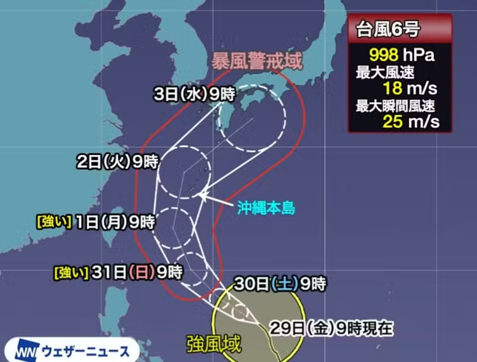
Typhoon Chanmi, classified as number 6, is moving slowly north, east of Filipinas. Sua trajectory indicates significant intensification in the coming days. Meteorologistas forecast the system to directly hit Okinawa and Amami between June 1 and 2 with high-force winds, marking the first typhoon to approach Okinawa since November last year.
From June 3rd, the natural phenomenon should move considerably closer to the west and east of Japão. Autoridades recommend maximum caution due to the possibility of intense rain in several regions, with impacts expected for the first weeks of next month.
Intensificação and direct impact on Okinawa and Amami
Typhoon number 6 is moving due to favorable conditions, such as sea surface temperature and winds, factors that contribute to its rapid strengthening. Espera is expected to intensify rapidly from Saturday, May 30th. Prevê Chanmi is expected to strengthen into a “strong” typhoon by Sunday, May 31, with maximum sustained winds of 33 m/s or greater near its center.
Ilha approaching Okinawa and Ilhas Amami with considerable strength is expected between Monday, June 1st and Tuesday, June 2nd. Como this will be the first typhoon to approach Okinawa this year, precautions are essential. The impact of intense rain, strong winds and high waves will be significant, therefore, the population must take preventive measures during the weekend to minimize risks.
- Às 9am on Friday, May 29, the latest data on Typhoon Chanmi was:
- Posição from center: Leste from Filipinas.
- Movimento: Noroeste at 15 km/h.
- Central Pressão: 998 hPa.
- Velocidade maximum wind speed: 18 m/s (near center).
- Velocidade maximum instantaneous wind speed: 25 m/s.
Alerta to the west and east of Japão with heavy rain
Next week will have a significant impact on both the west and east of Japão due to the progression of Typhoon Chanmi. As the system approaches Okinawa on Tuesday, June 2, a large amount of moist air will be directed toward Honshu. Este phenomenon will be driven by winds blowing between a high pressure system and the typhoon, creating conditions ripe for the formation of rain clouds.
Rain clouds should form particularly in Kyushu, Shikoku, on the southeast slopes of Península and Kii and around the frontal zone, areas directly affected by local topography. Strong Chuvas are expected in these regions, even when the typhoon is still distant. Precipitation is forecast to increase further as Chanmi approaches directly.
Prevê the typhoon is expected to change its trajectory eastward, aligning itself with the movement of a low pressure area moving away from the continent. The projection indicates that Chanmi will move considerably closer to Kyushu and Shikoku around Wednesday, June 3rd. The rain clouds coming from the typhoon itself will contribute to a scenario of intense precipitation, requiring maximum caution from authorities and the population.
Monitoramento trajectory and simulation models
Numerical simulation models calculated by meteorological agencies around the world provide a crucial reference for understanding Typhoon Chanmi’s projected trajectory. Cada thin line in these diagrams represents the results of numerical simulations using a method called ensemble prediction. Este method introduces intentional errors into the initial values, providing data that allows you to examine the reliability of the forecast comprehensively.
Comparando these results, there is a general consensus that the storm will approach Okinawa initially. Posteriormente, the typhoon is expected to change course to the northeast. Muitas forecasts indicate that it will continue in this direction along the southern coast of Honshu, directly influencing the region’s weather conditions.
However, as these predictions are for the relatively distant future, there is considerable uncertainty in the simulation results. The storm may not necessarily follow the trajectory where the lines converge most frequently. Especialistas claim that the prediction error will decrease as the days go by as more data is collected and simulations become more accurate. Continuous monitoring is essential to update information and issue effective alerts.