Severe Weather Threatens Middle Tennessee: Damaging Winds and Heavy Rain Expected

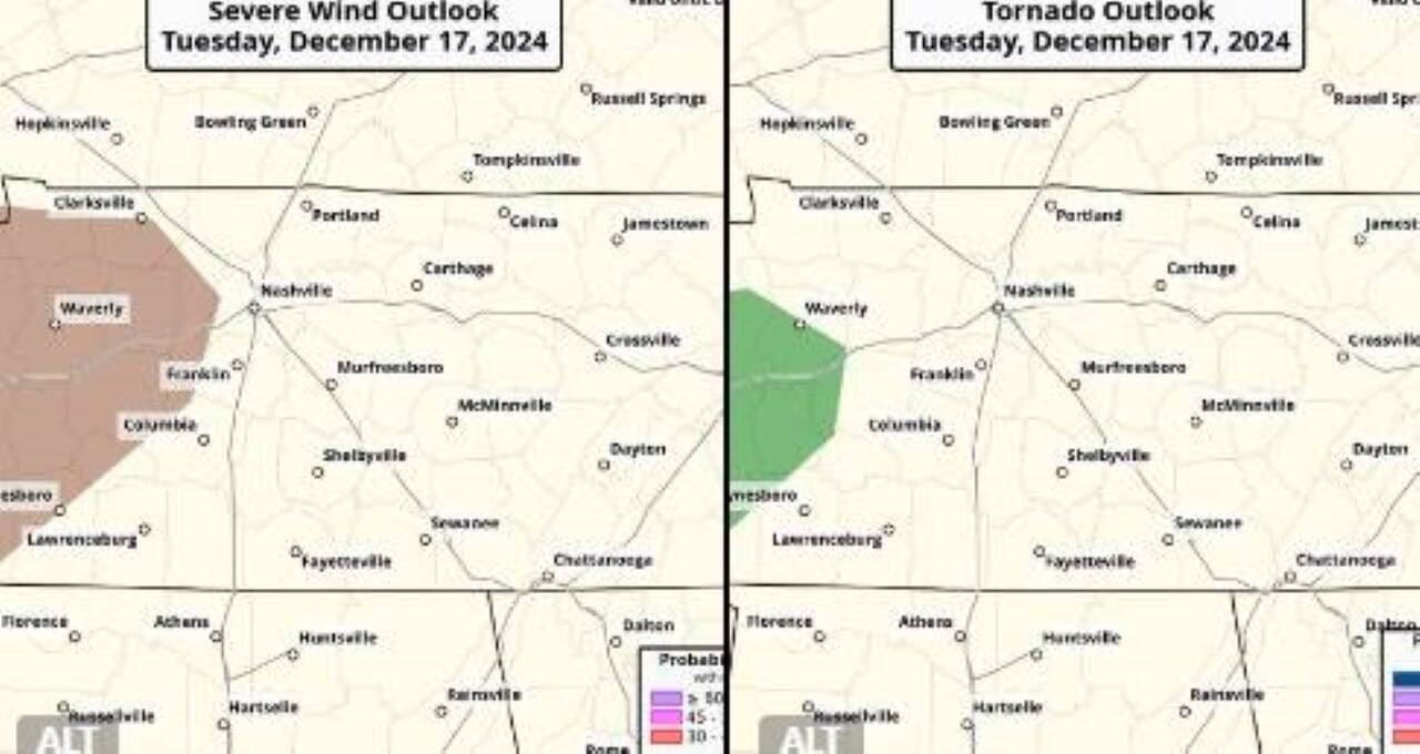
The National Weather Service (NWS) has issued a warning for Middle Tennessee, forecasting severe weather conditions with a marginal risk of storms and possible tornadoes early Wednesday. Damaging wind gusts and heavy rain are the primary threats as storms are expected to develop between 3 a.m. and 9 a.m. The advisory includes the potential for localized flooding in areas already saturated by recent rains.
Meteorologist Ryan Husted from the NWS emphasized the probability of severe storms in an email, stating that while tornado chances are low, they cannot be ruled out entirely. Residents in the affected areas are urged to stay vigilant and prepare for possible disruptions.
Timing and affected areas
The storms are forecasted to intensify during the early hours of Wednesday, primarily impacting areas north of Interstate 40 and west of Interstate 65. These regions, including northwest Nashville, have experienced multiple rounds of rainfall in recent days, increasing the risk of flooding.
The NWS may issue a flood watch for northwest Middle Tennessee, depending on additional rainfall in these already saturated zones. Heavy rain could lead to significant disruptions in travel and localized flooding in low-lying areas.
Recent weather patterns and their impact
Middle Tennessee has seen heavy rainfall over the past four days, contributing to saturated soil conditions. This increases the likelihood of flooding, especially in regions prone to water accumulation. While the current advisory includes a marginal risk of tornadoes, the area typically experiences 40-50 days per year with similar probabilities, according to Husted.
The NWS has highlighted that even a marginal risk should not be underestimated. Residents are advised to secure outdoor items, monitor weather updates, and prepare for possible emergency measures.
Detailed weather forecast for the week
Tuesday
- Day: Partly sunny with a high near 60°F and a 20% chance of showers after 5 p.m.
- Night: Showers and thunderstorms likely after 3 a.m., with a low around 53°F. Rainfall amounts between 0.25 and 0.5 inches expected.
There is some risk of severe storms from about 3 a.m. to 6 a.m. Wednesday. The primary threats are going to be severe wind (a 5-14% chance in the area highlighted in brown) & brief tornadoes (a 2-4% chance in the area highlighted in green). Severe threat will lessen after ~6 a.m. pic.twitter.com/bryKYTgb1c
— NWS Nashville (@NWSNashville) December 17, 2024
Wednesday
- Day: Temperatures will peak near 62°F by 9 a.m., then drop to around 50°F. Showers and thunderstorms are likely throughout the day, with precipitation chances at 90%. Rainfall amounts could reach 1-2 inches.
- Night: Partly cloudy with a low near 34°F.
Thursday through Monday
- Thursday: Mostly sunny with a high near 50°F and a low around 34°F.
- Friday: Sunny with a high near 43°F and a low around 29°F.
- Saturday: Mostly sunny with a high near 42°F and a low around 24°F.
- Sunday: Clear skies with a high near 42°F and a low around 25°F.
- Monday: Sunny with a high near 49°F.
Preparedness tips for severe weather
Residents are encouraged to take proactive steps to ensure their safety and minimize disruptions. Key recommendations include:
- Stay informed: Monitor local weather updates through reliable channels. The NWS will provide real-time alerts for changes in storm intensity or flood risks.
- Prepare an emergency kit: Include essentials such as water, non-perishable food, flashlights, batteries, and a first-aid kit.
- Secure property: Remove or secure outdoor items that could be displaced by strong winds.
- Avoid flooded areas: Do not attempt to drive through waterlogged roads, as even shallow flooding can be hazardous.
- Plan for power outages: Charge electronic devices and have backup power sources available.
Historical context of severe weather in the region
Middle Tennessee is no stranger to severe weather, with its climate prone to sudden changes and significant storm activity. The region has historically experienced flooding events, such as the devastating floods of May 2010, which caused widespread damage and displaced thousands.
In recent years, advancements in meteorological forecasting have improved early warning systems, allowing residents to prepare more effectively. However, the unpredictable nature of storms means that vigilance remains essential.
Community response and safety measures
Local authorities in Nashville and surrounding areas are on high alert, coordinating efforts to ensure public safety. Emergency services have urged residents to report hazards such as downed power lines or blocked roads immediately.
Community shelters and resources are on standby to assist those affected by potential flooding or storm damage. Schools and workplaces are advised to review emergency protocols and communicate contingency plans to students and employees.
Tornado safety reminders
While the probability of tornadoes remains low, it is crucial to be prepared. Tornado safety measures include:
- Identify a safe space: Seek shelter in a basement or an interior room on the lowest floor of your home, away from windows.
- Stay connected: Use a battery-powered radio or smartphone to receive updates and warnings.
- Protect yourself: Use sturdy furniture, blankets, or helmets to shield yourself from debris.
Importance of early preparedness
Severe weather events like those expected in Middle Tennessee highlight the importance of preparation and awareness. The combination of heavy rain, strong winds, and possible tornado activity underscores the need for residents to take advisories seriously.
By following safety guidelines and staying informed, communities can reduce risks and ensure a swift recovery from any potential impacts.