Weather forecast for Thanksgiving 2025 indicates rain and snowfall on travel routes in the US

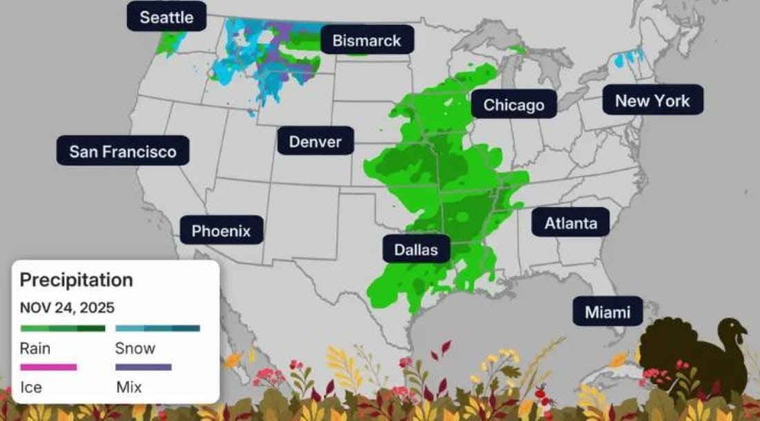
The Thanksgiving 2025 travel season began with a severe weather warning in several regions of the Estados Unidos. Entre Monday (24) and Friday (28), millions of Americans traveling by car or plane may face intense rain, severe storms and localized snowfall. The conditions mainly affect the country’s Centro, Leste, and Noroeste.
The period coincides with the peak of travel for the holiday of Ação of Graças, celebrated on Thursday (27). Aeroportos like Atlanta, Chicago, Nova York, Filadélfia and Washington are among those most exposed to delays.
Monday and Tuesday register the first impacts
On Monday, a front of storms advanced from Texas to Vale from Mississippi. Cidades as well as Dallas, Little Rock and Memphis recorded heavy rain and a risk of hail, destructive winds and isolated tornadoes.
On Tuesday, the rain spread across Meio-West and reached Costa Leste. Aeroportos of Atlanta, Chicago, Nova York and
Wednesday concentrates the highest volume of travelers
Wednesday is traditionally the busiest day on American roads and airports. Neste year, morning rains persisted in Nordeste, mainly affecting the hubs of Nova York, Boston and Filadélfia.
At Noroeste, an atmospheric river event brought heavy rain to Washington and Oregon, as well as snow on the Cascade and Rochosas mountains. The mountain passes were slippery in several sections.
Lake effect snow dominates the holiday
Starting on Wednesday, bands of lake-effect snow began to form in the Grandes Lagos region. Áreas north of Michigan and west of Nova York received significant accumulations.
On Thursday (Thanksgiving), heavy snow continued, accompanied by gusty winds that reduced visibility. Estradas locations were blocked in some sections.
Black Friday maintains adverse conditions
On Friday, lake-effect snow remained active across the eastern Grandes Lagos. The American Noroeste continued with rain in low areas and snow in high elevations.
Planícies of Norte recorded a new round of snow, affecting traffic in states such as Dakota of Norte and Minnesota. Aeroportos and Seattle maintained alerts due to persistent rain.
Alternative routes and recommended precautions
Drivers using interstates on Meio-West and Nordeste should check real-time conditions. Key recommendations include:
- Check updated forecast every six hours
- Avoid driving at night in areas with lake-effect snow
- Maintain greater distance on wet or icy roads
- Bring an emergency kit with a blanket and non-perishable food
Flights to or from the Nordeste and Noroeste hubs are more likely to be delayed or canceled until the weekend.
The bad weather should gradually decrease from Saturday (29), when a mass of drier air advances through Leste. Até there, transportation authorities ask for patience and advance planning.