Tornadoes cause two deaths in Indiana and six-inch hail hits Illinois region
The passage of a severe storm system through the Midwest from Estados Unidos on Tuesday night resulted in fatalities and significant structural damage. The extreme weather event generated multiple tornadoes that crossed the border between the states of Illinois and Indiana. Local authorities and rescue teams began search operations immediately after the first impacts were recorded in residential and rural areas.
The Serviço Nacional of Meteorologia confirmed the formation of supercells with high destructive capacity along the storm’s path. Meteorologists issued early warnings for the region, pointing out the imminent risk of extreme winds and ice precipitation in anomalous proportions.
The emergency corporation’s key initial records include the following points:
– Destruição total number of residences on the main route of the phenomenon.
– Queda massive electricity distribution network.
– Bloqueio of state highways by debris and trees.
– Acionamento of temporary shelters for the homeless population.
The rapid mobilization of contingency agencies prevented a greater number of victims in the most populated areas. Continuous monitoring of atmospheric conditions remains active, while the work fronts focus on clearing main roads and providing medical care to the injured taken to regional hospitals.
Structural damage and victims in the community of Lake Village
The location of Lake Village, located in the state of Indiana, recorded the most severe damage to human life during the passage of the frontal system. An elderly couple died after the tornado directly hit their residence, located in the 8000 block of 600 W Street. The force of the winds disintegrated the main structure of the property before residents were able to seek safe underground shelter.
Rescue teams began searching amid total darkness and rubble scattered across a wide radius. A contingent of around two hundred and fifty firefighters and volunteers divided the affected area into quadrants to carry out a systematic sweep. The grid search protocol ensured that no person remained on the missing list until the following morning.
Medical reports indicate that fewer than ten individuals suffered serious injuries in the same community. Algumas victims managed to travel by their own means to the nearest health units, while others were rescued trapped inside vehicles hit by large branches. The devastation zone extended for approximately five kilometers, even damaging the homes of four volunteer firefighters who were involved in the operation.
Ice precipitation reaches historic proportions in Illinois
The meteorological phenomenon produced hailstones with exceptional dimensions in the region of Kankakee, in the state of Illinois. Official records indicate the fall of ice fragments measuring up to six inches in diameter. Essa specific brand undergoes technical evaluation and has the potential to establish a new state record for solid precipitation.
Residents reported that falling rocks caused severe damage to the fleet of parked and moving vehicles. Para-windshields and side windows were instantly shattered, forcing drivers traveling on the highways to seek immediate refuge under overpasses and gas stations. Visibility on the roads dropped to critical levels during the height of the storm.


The formation of this type of hail requires extremely violent upward currents of air within the cumulonimbus cloud. Baseball-sized ice also reached adjacent suburban areas, such as Homer Glen, expanding the perimeter of material destruction. Local insurance companies have already begun the process of surveying automobile and residential losses.
The sound of the precipitation was described by witnesses as the continuous clash of projectiles against metal bodies and the roofs of houses. The mechanical force of the giant hail pierced the roofs of agricultural warehouses and destroyed entire plantations that were in the path of the supercell, generating substantial economic losses for the region’s agricultural sector.
Rescue and shelter operations in Kankakee County
In the county of Kankakee, health authorities confirmed the care of nine injured people, with no local fatalities reported. The tornado traced a route close to the city’s exhibition park and headed northeast until reaching the location of Aroma Park. The area along Sandbar Road concentrated most of the structural destruction, including the total collapse of a two-story barn and the collapse of a massive concrete silo, structures that could not withstand the aerodynamic pressure generated by the tornado’s vortex.
Mayor Christopher Curtis coordinated the work fronts that rescued residents trapped in the rubble of the affected residences. Para ensure the safety of the homeless, Cruz Vermelha Americana established an emergency reception center on the premises of Kankakee Community College. The shelter provides food, primary medical assistance and logistical support to families who lost their homes, while civil engineering teams assess the integrity of the buildings that remain standing in the affected area.
Technical assessment and mapping of the supercell trajectory
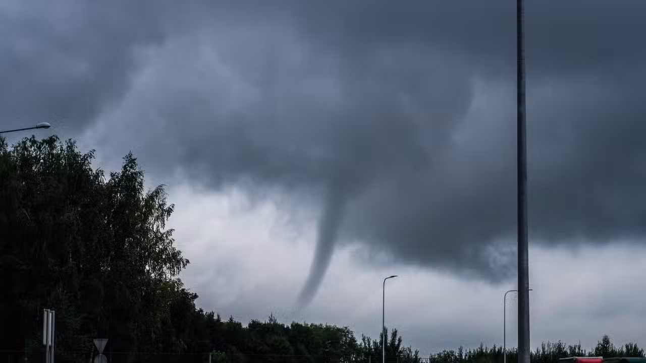
Serviço Nacional of Meteorologia dispatched specialized damage survey teams to map the exact trajectory of the phenomena and classify the intensity of the tornadoes in Escala Fujita Melhorada. The supercell responsible for the destruction formed in the vicinity of Pontiac, in Illinois, and maintained its structural organization as it crossed the state border towards Indiana. The atmospheric system produced multiple vortices that touched down in areas such as south of Kankakee, Lake Village and Wheatfield. The combination of long-lived tornadoes and giant hail is a classic feature of well-developed supercells that encounter favorable thermodynamic conditions, such as high instability and strong wind shear in the central Estados Unidos region. Meteorologists’ work in the field involves closely analyzing debris dispersion patterns, measuring marks left on the ground, and assessing damage to native vegetation to determine maximum wind speeds. Rigorous collection of physical evidence allows scientists to reconstruct event dynamics with high precision. Esses data is essential for improving numerical weather prediction models and increasing the reliability of early warning systems, reducing the population’s response time to extreme weather events. Photographic documentation and radar measurements also make up the final report that will be integrated into the national climatological database, helping to study severe storm patterns over the decades.
Restoration of essential services and infrastructure
The storm’s passage caused the collapse of much of the electrical distribution infrastructure in both states. The force of the winds knocked down approximately seventy high and medium voltage poles in Newton county alone. Utility company NIPSCO reported that more than two thousand five hundred customers were without power in the first few hours after the event.
In the state of Illinois, the company ComEd recorded a peak of twenty-seven thousand consumer units disconnected from the grid. Maintenance teams worked around the clock throughout the night, managing to reduce the number of points without power to around four thousand by the following morning. The official forecast indicates that the complete normalization of the electrical system in the most isolated rural areas will require several days of intensive work.
Government Coordination and Security Guidelines
The state administration of Illinois mobilized the emergency management agency to provide logistical and financial support to the affected municipalities. Government work fronts work together with city halls to accelerate the release of resources intended for the reconstruction of destroyed public infrastructure.
Traffic and public safety authorities have reinforced guidelines for the population to avoid unnecessary travel on local highways. The presence of energized high voltage cables on the ground and the risk of falling partially damaged trees represent imminent dangers for drivers and pedestrians.
Continuous monitoring of atmospheric conditions
Weather forecasting centers monitor cold fronts that cross the central North American plain. The standard recommendation directs residents to keep emergency kits prepared and weather radios activated to receive instant updates on new severe storm formations in the region.
Veja Tambem em News (EN)

Research reveals that parents are unaware of how their children use artificial intelligence

Samsung releases new system update with new features for Galaxy Watch 4 users

Digital retail reduces the value of the Galaxy S25 5G smartphone with bank bonuses and device exchange

Amazon’s wireless CarPlay adapter has a 50% discount and high approval ratings from drivers

Zach Cregger’s new Resident Evil ignores games and focuses on an unprecedented story with new characters

Rumor suggests that Nintendo is preparing a special edition of the Switch 2 with a remake of Ocarina of Time

Apple accelerates production of the iPhone 17e and develops new Air model with dual camera system

Epic Games platform releases twelve high-budget games at no permanent cost for PC users

PlayStation 5 Pro price drop accelerates digital retail sales and eliminates global stocks

New Galaxy Watch 9 firmware appears on server and confirms progress in software development

Apple’s commemorative project tests cell phone with 1.1 millimeter edge and curved screen for 2027
