
Study of 50,000-year-old crater in Arizona reveals crucial data for global planetary defense

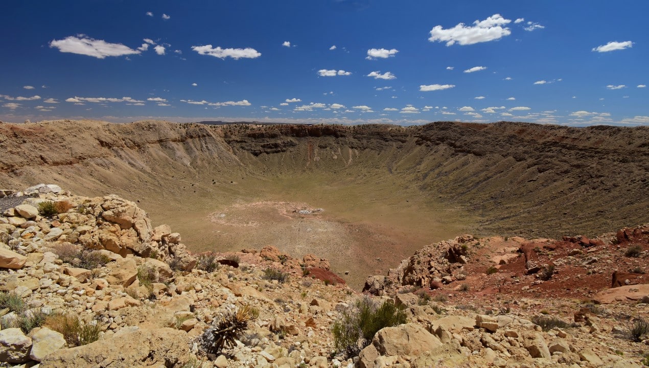
A cosmic event of gigantic proportions reached the Earth’s surface around 50 thousand years ago, leaving a deep mark on the arid landscape of the state of Arizona, in the Estados Unidos. The geological formation resulting from this direct impact remains to this day one of the best preserved collision areas on the entire planet.
The structure impresses with its exact measurements, presenting a diameter that exceeds the 1,200 meter mark and reaching a depth of 210 meters in the rocky soil. The site serves as an invaluable natural laboratory for the international scientific community, providing continuous data on the physical processes that have shaped our planet over millions of years.
The area’s exceptional level of conservation allows researchers from different parts of the world to conduct detailed analyzes of the interaction of Terra with the space environment. Cada new excavation or topographic mapping carried out at the site helps unravel the exact mechanics of catastrophic events originating in deep space.
Recognition of the spatial origin of the formation
The true nature of the crater was the subject of intense academic debate during the first decades of the twentieth century. Inicialmente, the community of geologists attributed the enormous circular depression to volcanic processes, a common theory for similar formations found in other regions of the globe.
The scenario changed drastically following investigations led by mining engineer Daniel Barringer, who challenged the scientific consensus of the time. Ele dedicated much of his career and financial resources to the search for physical evidence that would prove the theory of an extraterrestrial impact.
His persistence in drilling the ground in search of the main body of the meteorite, which he believed was buried beneath the structure, resulted in the discovery of fragments of iron and nickel. Esses material findings paved the way for the definitive recognition of the site as a true impact crater.
The validation of this theory represented a milestone in modern geology, reshaping global understanding of the dynamics of cosmic collisions. The analysis method established in Arizona served as the basis for identifying numerous other craters around the world that had previously been ignored or incorrectly interpreted.
Collision dynamics and energy release
The event responsible for creating the depression involved a metallic meteorite composed predominantly of nickel and iron, with an estimated diameter of 50 meters. The celestial body crossed the Earth’s atmosphere and reached the ground at an extreme speed, estimated between 12 and 20 kilometers per second.
The kinetic energy released at the exact moment of impact was equivalent to several megatons of conventional explosives. Essa colossal force instantly vaporized much of the meteorite itself and the rocks present at the point of contact, generating a massive shock wave that excavated the circular basin visible today.
Climatic factors and land preservation
The uniqueness of Cratera of Barringer, as it is also known, lies in its almost intact state of conservation over five decades. Diferente than other ancient geological formations, the site has not suffered severe degradation from tectonic activity or constant water erosion.
The predominantly arid climate of Arizona played a key role in maintaining the original features of the rim and bottom of the depression. The absence of large bodies of water or rivers in the immediate vicinity prevented the weathering of rocks ejected during the initial explosion.
This environmental stability has provided scientists with a geological record of unprecedented clarity. The layers of rock exposed in the crater walls remain in their relative positions, allowing the precise study of mineral changes caused by thermal and mechanical shock.
Mineral changes under extreme pressure
Geological investigations carried out inside the crater revealed the abundant presence of shock minerals, specifically forms of silica known as coesite and stishovite. Esses elements crystallize exclusively under conditions of absolutely extreme pressure and temperature, identical to those generated by very high speed impacts. The identification of these minerals was the determining factor in attesting to the meteoric origin of the structure, irrefutably differentiating it from volcanic calderas and confirming the violence of the cosmic event that hit the region. The spatial distribution of these minerals throughout the basin provides an accurate heat map of the milliseconds following the meteorite’s initial contact with the Earth’s crust.
Thorough analysis of the rocks exposed in the steep walls allows the exact reconstruction of the impact sequence of events, from the moment of material ejection to the formation of complex breccia structures. Modern mass spectroscopy and X-ray microanalysis technologies offer a detailed understanding of nanometer-scale processes. Researchers are able to identify unique chemical signatures in the rocky fragments, revealing the exact composition of the original celestial body and the thermodynamic conditions to which the soil of Arizona was subjected. Cada sample collected and cataloged works as an inviolable temporal record, keeping the physical properties of an event that permanently altered the local geography.
Preparation for space exploration missions
In addition to its immense value to Earth’s geology, the crater has established itself as an indispensable and practical training ground for manned and robotic space exploration programs. Agências spacecraft uses the rugged topography and distribution of ejected rocks to simulate the surface conditions found on Lua and Marte. Astronautas and engineers test mobility equipment, pressure suits, and sample collection protocols in the arid environment of Arizona before official missions. The morphological similarities between this terrestrial formation and craters observed on other celestial bodies in the solar system make the site an ideal testing environment for the development of new autonomous rover navigation technologies. Directly studying debris distribution and edge structure helps planning teams understand how rovers should behave when descending into extraterrestrial impact basins. Essa continuous practice mitigates operational risks and ensures the efficiency of scientific data collection millions of kilometers away from Terra. The bowl-shaped topography offers locomotion challenges identical to those robotic probes face when exploring Martian craters in search of ice or ancient riverbeds. The visual mapping carried out by teams on the ground at Arizona serves to calibrate optical instruments that currently orbit other planets. Toda this natural infrastructure converts a geological scar into a direct bridge for the advancement of contemporary aerospace engineering.
Direct implications for planetary defense
The data extracted from the ongoing analysis of the impact on Arizona transcends the study of the geological past and applies directly to contemporary strategies for monitoring outer space. The site serves as a scale model to understand the physical mechanisms of collisions that pose real risks to global infrastructure and modern population density.
Understanding the propagation of shock waves and the dispersion of atmospheric debris helps refine computer simulations used by international astronomical surveillance networks. Organizações monitoring systems track thousands of asteroids and comets close to Earth’s orbit, using the physical parameters validated in Arizona to calculate the destructive potential of newly discovered objects.
The ongoing study of catastrophic events
The crater acts as a microcosm that illustrates the physical consequences of larger impacts, such as the event that hit Península of Yucatán 66 million years ago. Advanced three-dimensional geophysical mapping of the subsurface in Arizona continues to provide vital information about how the Earth’s crust reacts to massive, instantaneous transfers of cosmic energy.



