Weather forecast for tomorrow: KELOLAND region records near-record heat and faces sudden drop with chance of snow

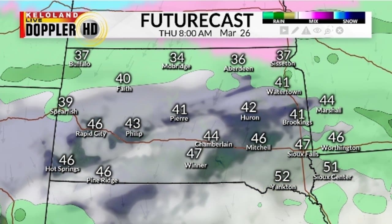
The KELOLAND region is experiencing a day of extreme weather, with high temperatures approaching record levels this Tuesday, March 25, 2026, before a drastic change to much colder conditions, which will bring the possibility of snow. Enquanto the heat prevails today, generating fire alerts in some areas, the expectation is for a complete reversal in the meteorological scenario starting tomorrow.
Meteorologists are closely monitoring the arrival of a mass of cold air from Canadá, which promises to bring down thermometers and bring strong winds. Essa transition marks the end of a period of mild weather and the beginning of a phase of instability, which will last for the next few days, requiring attention from the population.
Record heat trend and fire warning
An atypical heat wave for the time of year dominates KELOLAND this Tuesday, pushing thermometers to high levels. Em Sioux Falls, for example, temperatures are projected to approach 80 degrees Fahrenheit (about 26.7 degrees The thermal sensation can be even greater in urban areas, increasing discomfort.
At the same time, the dry climate and high temperatures significantly increase the risk of fires. The southwest area of KELOLAND is under high fire danger alert, with authorities recommending extreme caution to the population to avoid any action that could start fires. The combination of parched vegetation and heat creates an environment conducive to the rapid spread of flames, making prevention a top priority.
Sharp turn: Ventos cold and possible snow
The apparent stability of warm weather will be short-lived. A radical change in atmospheric conditions is expected in the coming hours. Although winds remain mild in many regions today, the situation will change drastically at night, with the intensification of winds from the north, signaling the arrival of a cold front.
The cold air mass originating from Canadá will cause temperatures to plummet this Wednesday. In locations such as Aberdeen and Mobridge, in the north of KELOLAND, the forecast is that thermometers will not exceed 30 degrees Fahrenheit (about -1.1 degrees Essa abrupt fall will be accompanied by the real possibility of snow.
The Futurecast, a weather forecast model, points to the persistence of current warming trends, but also highlights the probability of precipitation in the form of snow in the north of the region this Wednesday. The population of these areas must prepare for a sudden return to winter, with the need for appropriate clothing and extra care when driving.
Outlook for the weekend and early April
The trend of colder weather will persist until this Friday, although with the expectation of clear and sunny skies, without the same chances of snow as Wednesday. Este transition period will offer brief relief before a new warming phase. The weather will start to get milder again during the next weekend, with this trend consolidating at the beginning of next week, bringing a breather to the region’s residents.
However, from April 1st, the meteorological dynamics promise to intensify in KELOLAND and across the plains. Especialistas in weather predict the arrival of a more active weather pattern, characterized by a series of storm systems that will bring rounds of thunderstorms, rain and, again, snow. Este complex scenario will require constant monitoring.
The possibility of accumulating snow is a real concern, especially in some parts of the northern Plains. The forecast points to the formation of very sharp temperature lines during this period, which could result in varied and unpredictable weather phenomena. Detalhes additional information about these systems should be released in the coming days, keeping residents alert for future updates and planning.
Regional impacts of climate instability
Thermal variation in KELOLAND not only affects daily comfort, but also has significant implications for several sectors. High relative humidity, although absent at this time of fire warning, is a factor that can change quickly. The forecast of strong winds, initially light, but intensifying, could cause disruption, especially for air traffic and river navigation. Produtores rural areas, in turn, need to adapt their planting and harvesting schedules in the face of these unexpected fluctuations.
The Black Hills region, for example, is already facing stronger winds, which will expand even further during the night and on Wednesday, following the arrival of colder air. Essa condition may impact outdoor activities and require greater attention from drivers on more open stretches. Local infrastructure, including electrical grids, can also be tested by intense gusts, raising the need for contingency plans.
Schools and public services are preparing for the possibility of sudden changes, such as suspended classes or changes to transport. Accurate and early information is crucial to ensuring community safety, minimizing the negative impacts of these climate events. Effective communication between authorities and the population is essential for a coordinated and efficient response.
Preparation for multiple phenomena
Faced with a scenario of such climate variability, preparation becomes essential for the residents of KELOLAND. Desde from protection against forest fires in risk areas to adapting to low temperatures and snow, the population must pay attention to the recommendations of local authorities and meteorological services. Inspecting heating systems, sealing windows and doors, and maintaining vehicles for winter conditions are important measures.
For the next few days, the focus should be on monitoring updated forecasts. The complexity of the storm system expected in April, with its mix of rain, thunderstorms and snow, requires every home and business to have an action plan. Acompanhar weather warnings and taking precautions such as having emergency kits on hand and ensuring basic supplies can make a difference in everyone’s safety and well-being.
Detailed Forecast Highlights
A previsão detalhada para os próximos dias em KELOLAND ressalta pontos cruciais que merecem atenção:
These details reinforce the importance of continuous attention to weather updates, ensuring that residents are well informed to adapt to the region’s rapidly changing climate.