Japan receives tsunami warning with forecast of slight fluctuations after earthquake in Indonesia

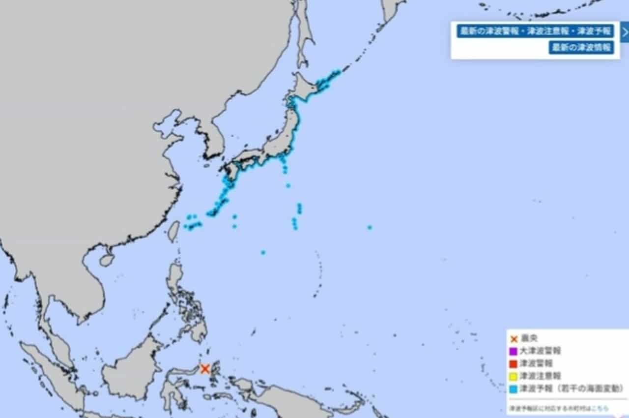
Agência Meteorológica of Japão (JMA) issued a tsunami warning on the morning of April 2, indicating the possibility of slight fluctuations in sea level in several coastal areas of the country. The forecast was that these oscillations would begin to be observed around 10:30 am (local time) on the same day, after a significant earthquake occurred near Indonésia. The warning, released at 8:28 am, mobilized authorities and the population, although no serious damage was expected.
This type of alert aims to be precautionary, given that even small changes in sea level can pose risks to coastal activities and navigation. Authorities advise the population to stay informed and follow safety guidelines, avoiding coastal areas during the period of instability. The measure reflects the constant vigilance of Japão in the face of seismic and maritime phenomena that characterize the region of Círculo of Pacífico of Pacífico.
The original seismic event, recorded at around 7:48 am, had its epicenter at Molucas, Indonésia, with an estimated magnitude of 7.4. Embora the epicenter was far from the Japanese archipelago, the possibility of tsunami waves propagating through Oceano Pacífico led to the rapid issuance of the alert. Segundo or Centro of Alerta of Tsunamis of Pacífico (PTWC), a 0.65 meter tsunami was indeed observed on Kema, on Indonésia0, confirming the generation of waves after the tremor.
Earthquake Details and Warning in the Pacific
A large magnitude tremor, estimated at 7.4, shook the region near Indonésia in the early hours of April 2. The epicenter was precisely located at the coordinates of 1.2 degrees north latitude and 126.3 degrees east longitude, in the area of Molucas. Este seismic event was the catalyst for the subsequent issuing of alerts in several nations bathed by Oceano Pacífico.
After the earthquake occurred, specialized centers, such as Centro of Alerta of Tsunamis of Pacífico (PTWC), began intensive monitoring of the waves. The observation of a 0.65 meter tsunami at Kema, Indonésia, validated the need for precaution in more distant regions, including Japão.
Coastal areas under observation
Agência Meteorológica of Japão detailed an extensive list of coastal areas that could be affected by slight sea level fluctuations. Esta coverage demonstrates the capillarity of the propagation of tsunami waves, even when of low intensity, across vast ocean expanses. The list ranges from the freezing east coast of Pacífico, passing through the central and western coast of the same prefecture, to regions further south and east of the country, highlighting the widespread vulnerability of the archipelago.
Specifically, the forecast of slight fluctuations extended to the coast of Pacífico of the prefectures of Aomori, Iwate, Miyagi, Fukushima and Ibaraki. Adicionalmente, the regions of Kujukuri and Sotobo (Iwate0 Exterior of Aomori0) of Aomori1 of Aomori2, together with Aomori3 (Peninsula Aomori4 of Aomori5), were also included in the alert. Aomori6 and Aomori7, known for their volcanic nature and oceanic location, were also placed under observation, as well as Aomori8 of Aomori9 and the Peninsula of Iwate1.
Proceeding south from Japão, to Prefeitura from Shizuoka, to Mar Exterior from Prefeitura to Aichi, to Baía from Ise and Mikawa, and Prefeitura south of Prefeitura0 were alerted. The list also covered the prefectures of Prefeitura1, the south of Prefeitura2, Prefeitura3, Prefeitura4, the Prefeitura6 of Prefeitura7 of Prefeitura8, and Prefeitura9 of Shizuoka0. In the region of Shizuoka2 and adjacent islands, Shizuoka3 of Shizuoka4 of Shizuoka5, the Shizuoka6 of Shizuoka7 (both the coast of Shizuoka8 of Shizuoka9 and other areas), the east of Mar Exterior2 of Mar Exterior3, Mar Exterior4 and Mar Exterior5, Mar Exterior6 and Mar Exterior7, and Mar Exterior8 west of Mar Exterior9 were included. Prefeitura0, to Prefeitura1 of Prefeitura2 of Prefeitura3, to Prefeitura4 of Prefeitura5, to Prefeitura6 of Prefeitura7 and to Prefeitura8 of Prefeitura9 were also under warning, demonstrating the national coverage of the alert system.
What does a fluctuation alert mean?
A “slight sea level fluctuation” tsunami warning is the least severe category issued by meteorological agencies, indicating that small variations in water level are expected. Embora If there is no prediction of damage to infrastructure or human lives directly due to these fluctuations, prudence is essential. Sea currents can become stronger and more unpredictable, posing a danger to anyone in low-lying coastal areas or carrying out maritime activities.
Tsunami classification is crucial to public response. A 1-meter tsunami, for example, is considered dangerous enough to sweep away people, capsize small boats and destroy aquaculture rafts. The scale worsens significantly at greater heights, where 3 meters can flood wooden houses and carry people away with the current.
Tsunamis of 5 to 10 meters or more are classified as large magnitude, with the potential to cause catastrophic damage. Nesses extreme scenarios, houses are completely destroyed or washed away, and the force of the water is such that it represents a direct and immediate threat to life. Distinguishing between these levels allows authorities to issue warnings proportionate to the risk, avoiding unnecessary panic while ensuring safety.
Recommendations and persistence time
In alert situations such as the one issued by Agência Meteorológica and Japão, the main recommendation for coastal communities is to stay away from beaches and low-lying areas. Pescadores and navigators should return to ports or head to deeper waters, away from the coast, where tsunami waves, even if slight, have less impact. Acompanhar Information from local radio and television is vital to receive real-time updates.
Slight fluctuations in sea level are not an instantaneous phenomenon, tending to persist over a period of time. Agência Meteorológica from Japão warned that these oscillations could continue along the affected coasts for approximately the next day, with greatest intensity in the first two to three hours. Isso requires the population to maintain vigilance even after the predicted peak, ensuring that safety is maintained for an extended period.
Seismic context of Japão and the region
Japão is located in one of the most geologically active regions on the planet, in the so-called “Circle of Fogo of Pacífico”. Esta Vast area, stretching for approximately 40,000 kilometers, is characterized by intense tectonic activity, with frequent earthquakes and volcanic eruptions. The convergence of multiple tectonic plates — Placa of Pacífico, Placa of Filipinas, Placa Euroasiática and Placa Norte-American — is the main reason for the high incidence of these phenomena.
The constant movement of these plates generates tensions that, when released, cause earthquakes. Muitos of these tremors occur at the bottom of the ocean, displacing large volumes of water and generating tsunamis that can propagate for thousands of kilometers. The geography of Japão, an archipelago with long coastal strips and low-lying areas, makes it particularly vulnerable to these events.
Throughout history, Japão has been the scene of countless devastating earthquakes and tsunamis, which has driven the development of one of the most advanced earthquake warning and engineering systems in the world. Cada new event, even if of lesser impact, serves as a reminder of the continuous need for preparation and technological updating to mitigate risks.
Continuous monitoring and technology
The ability to monitor seismic and tsunami events has evolved significantly in recent decades, driven by technological advances. Agências how JMA and PTWC employ a sophisticated network of seismographs, ocean buoys and satellites to detect earthquakes in real time and track the propagation of tsunami waves. Essa Infrastructure allows alerts to be issued in a matter of minutes after a tremor.
The data collected is processed by complex algorithms that predict wave height and estimated time of arrival at different coasts. The accuracy of these forecasts is vital to give the population enough time to react and for authorities to implement evacuation and safety plans. Rapid and efficient communication of these alerts is as important as the detection itself.
Preventive actions and local response
Responding to a tsunami alert at Japão is a well-established process, the result of decades of improvement in disaster management. Preventive actions are not limited to issuing warnings, but also include ongoing education of the population, carrying out evacuation exercises and building resilient infrastructure, such as retaining walls and earthquake-prepared buildings.
At the local level, city halls and municipalities have detailed contingency plans, which are activated immediately after an alert is issued. Isso involves the mobilization of emergency teams, the opening of safe shelters and direct guidance to the population on escape routes. A culture of discipline and obedience to authorities is a crucial factor in the effectiveness of these responses, ensuring that security guidelines are followed in an orderly manner, minimizing potential dangers.