Viral image of the Moon with vibrant colors is the work of a Ukrainian photographer and has no relation to NASA

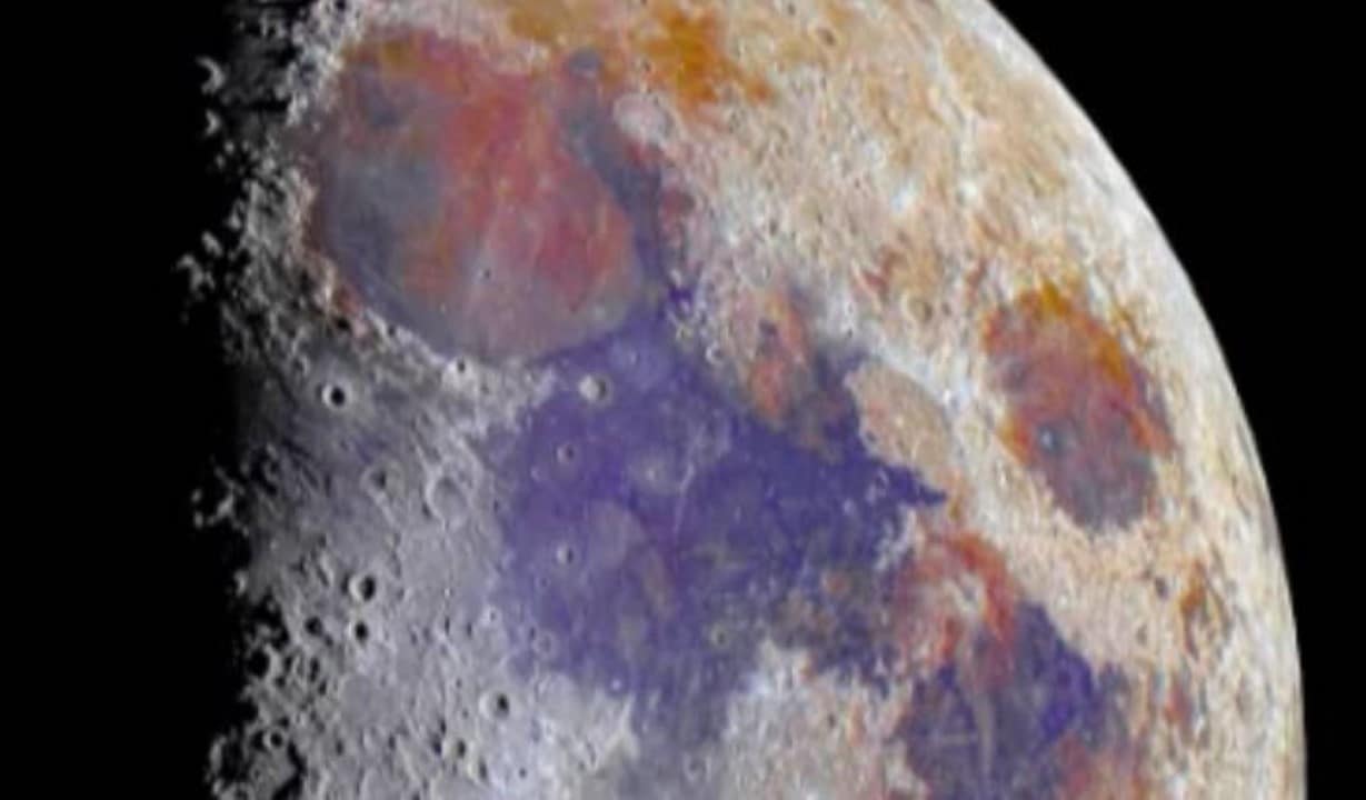
A photograph of the natural satellite Terra, showing a surface covered in intense shades of blue, pink and green, gained widespread attention on digital platforms recently. The image was widely shared by users who believed it was an official and unprecedented record captured by recent space missions.
The North American space agency was frequently cited in viral publications, with internet users associating the material with the program Artemis. The rapid dissemination of the content generated debates about the true visual characteristics of the celestial body and the capacity of new exploration equipment.
The record, however, is an independent work of astrophotography that uses saturation techniques for geological mapping purposes. The authorship belongs to a professional from Ucrânia who applied digital processing methods to highlight chemical elements present in the lunar crust.
Origin of registration and color saturation process
Photographer Ibatullin Ildar is truly responsible for creating the image that captured the attention of the global public. The professional took the original captures from terrestrial equipment and later submitted the files to image editing software focused on astrophotography.
The procedure adopted does not insert artificial elements or alter the topography of the craters and plains. The technique consists of raising the saturation levels of the color channels extremely, revealing nuances that the sensors capture, but which are invisible in conventional observation with the naked eye.
This method generates what experts call a false-color map, a visual representation designed to highlight the mineralogical composition of the soil. The practice is widespread both in the community of amateur astronomers and in advanced research laboratories around the world.
To understand the structure of the viral image, it is necessary to observe the following points about the technique applied in processing the original files:
- The base photographs are real and unaltered records in their spatial geometry.
- The software amplifies light signals reflected by different minerals in the crust.
- The final stain strictly serves as a chemical map of the surface.
- There is no involvement of government agencies in the production of this file.
Identification of minerals through the light spectrum
The distribution of colors in the edited photograph follows strictly geological criteria, functioning as a direct indication of the presence of specific metals. The vast regions that take on a dark blue color point to areas with a high concentration of titanium, a fundamental element for the study of past volcanic activity.
On the other hand, areas that stand out in shades of orange, red and pink indicate the presence of iron oxides spread across different rock formations. The greenish areas mark the transition zones between these different mineral deposits, creating the multicolored appearance that surprised Internet users and generated scientific curiosity.
Contrast between natural observation and digital mapping
The natural satellite of Terra does not have its own light, acting only as a large reflector of the lighting coming from Sol. The lunar surface is mainly composed of rocks and dust that reflect light almost uniformly, resulting in the grayish appearance that humanity has observed for millennia in the night sky.
There are subtle variations in albedo, which is the reflective capacity of a surface, depending on the region observed by the telescope lenses. However, these tonal differences are extremely weak and cannot be detected without the aid of optical amplification instruments and computer data processing.
Digital editing works precisely to capture these microscopic variations, multiplying the intensity of the signals until they become evident to the human eye. The end result is a powerful study tool, although it does not represent the visual reality that an astronaut would encounter while orbiting the celestial body in a spacecraft.
Importance of chemical mapping for space exploration
The false-color technique, although it became popular through the work of independent photographers, is a fundamental pillar in planning missions to explore the solar system. Sondas orbiters use multispectral cameras to scan the surface of planets and satellites, generating terabytes of data that are later converted into color maps. Esses visual documents allow scientists to identify the most promising locations for landing modules and collecting samples, optimizing resources and timing for interplanetary missions funded by global agencies.
The precise identification of titanium and iron deposits has invaluable strategic value for colonization projects and the establishment of permanent bases outside Terra. Prior knowledge about the location of these minerals facilitates the development of technologies for using resources in situ, where future explorers will be able to extract raw materials directly from the lunar soil to build habitats and manufacture equipment, reducing dependence on supplies sent from our planet and lowering operational costs.
The role of astrophotography in scientific dissemination
The work developed by professionals such as Ibatullin Ildar demonstrates the significant evolution of observation equipment and processing software available to the public outside large scientific institutions. Creating a detailed image of lunar geology requires capturing hundreds or even thousands of individual frames, which are then stacked and aligned to reduce atmospheric noise and increase geometric sharpness. Após In this stabilization step, the color channels are separated and manipulated individually, requiring in-depth knowledge of both photography and the physical properties of light. Essa strand of astrophotography, often called Mineral Moon, acts as an important bridge between complex academic knowledge and the curiosity of the general public. By transforming dry spectrometry data into visually striking images, these photographers are able to spark interest in planetary geology and space science, proving that observation of the cosmos is not just restricted to large government telescopes, but can be explored with technical rigor from the Earth’s surface.
Dynamics of data sharing and interpretation
The virality of the multicolored image highlights how impressive visual content can quickly lose its original context when circulating on digital platforms. The absence of explanatory captions about the editing process led thousands of people to interpret the chemical map as a true-color photograph recently captured by state-of-the-art satellites.
Experts in scientific communication emphasize the need to accompany processed records with clear information about the methods used in their conception. Transparency about the application of false color prevents the spread of misconceptions about the nature of celestial bodies and the functioning of astronomical research instruments.
The current scenario of satellite return missions
The fascination generated by edited photography occurs at a time of intense movement in the aerospace sector, with several nations preparing to send new crews and equipment into lunar orbit. Projetos in progress focus exactly on the detailed prospecting of these mineral resources, using mapping technologies that operate under the same optical principles demonstrated in the work of the Ukrainian photographer, aiming to guarantee the sustainability of future operations in deep space.