Yamanashi Prefecture in Japan is hit by a magnitude 6 earthquake, without a tsunami warning
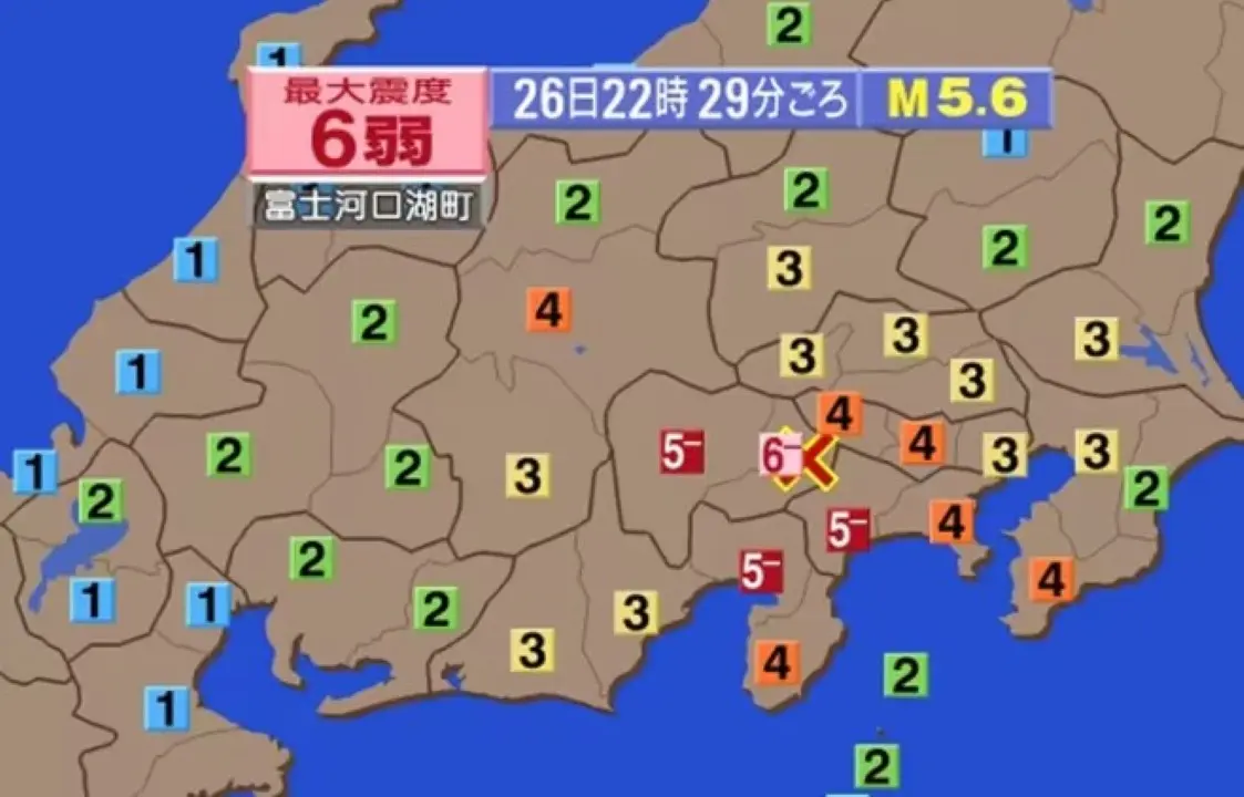
A magnitude 6.0 earthquake shook Japan’s Yamanashi prefecture on the night of June 26, at around 10:28 pm (local time). Authorities confirmed that there is no forecast of a tsunami after the seismic event.
In Fujikawaguchiko, Yamanashi Prefecture, the seismic intensity reached 6-, while the city of Otsuki recorded a 5+ tremor.
Additionally, several other locations felt 5- tremors. Among them are the neighborhood of Midori, in Sagamihara, as well as Matsuda, Nakai and Yamakita, all in Kanagawa Prefecture. In Yamanashi, Kofu, Fujiyoshida, Fuefuki, Koshu, Fujikawa, Nishikatsura, Oshino, Yamanakako and Narusawa were also affected. The city of Oyama, in Shizuoka, also recorded tremors.
Seismic intensity 4 was felt over a wide area, including Minamiboso in Chiba Prefecture and several cities in Tokyo such as Hachioji and Machida. In Kanagawa, locations such as Yokohama and Kawasaki were hit. Tsuru and Minami-Alps, in Yamanashi, also recorded the same level of tremor, as did Kawakami, in Nagano, and Numazu, in Shizuoka.
Lesser intensity tremors, ranging from magnitude 1 to 3, were reported over an extensive geographic area, covering the regions of Tohoku, Kanto-Koshinetsu, Tokai, Hokuriku, Kinki and Chugoku.
The Japan Meteorological Agency identified the epicenter of the earthquake in the eastern region of Yamanashi Prefecture, close to the Fuji Five Lakes. The tremor occurred at a depth of 20 kilometers, with the magnitude initially estimated at 5.6.
The exact time of the seismic event was later revised to approximately 10:28 p.m.
After a thorough analysis of the data, the Japan Meteorological Agency corrected the time of the earthquake that reached 6- on the Richter scale in Yamanashi, from 10:29 pm to 10:28 pm on June 26.
Details about the tremors and impacts
Kanagawa, Yamanashi and Shizuoka prefectures recorded long-term seismic movements, classified as “Class 1”.
At around 10:29 pm on June 26, an intensity 6- tremor hit Yamanashi, and at the same time Kanagawa, Yamanashi and Shizuoka felt a prolonged and slow ground movement, categorized as “Class 1” of long period.
Among the four levels of long-term movement, “Level 1”, the lowest, was identified in places such as the Tsurumi neighborhood in Yokohama and the cities of Hiratsuka and Hadano in Kanagawa Prefecture. In Yamanashi, Koshu and Fujikawaguchiko also recorded this level, as did Gotemba, in Shizuoka Prefecture.
This long-term ground movement phenomenon is characterized by intense and prolonged vibration, lasting more than 2 seconds. It generally occurs during large earthquakes and is notorious for impacting especially high-rise buildings.
According to the Japan Meteorological Agency, a “Class 1” tremor is described as “moderately strong.” In these cases, most occupants of tall buildings notice the shaking, and hanging items such as curtains visibly sway.
Current condition of Mount Fuji after the earthquake
The Japan Meteorological Agency said monitoring systems at Mount Fuji detected no significant changes following the recent earthquake.
Leia Também

Messi reaches 19 goals in FIFA World Cups with great free kick for Argentina in clash with Jordan

Cristiano Ronaldo shines beyond the pitch at the 2026 World Cup with business empire and family luxury

At 41, Cristiano Ronaldo reaffirms his historic legacy and prepares to shine in the 2026 World Cup
Safety recommendations for high-intensity tremors
The Japan Meteorological Agency details that an earthquake with intensity 6- makes it difficult to remain standing, and most furniture that is not fixed inside homes tends to move or tip over.
In the event of broken crockery or glass objects on the floor, it is crucial to avoid accidents during cleaning. It is recommended to wear slippers or shoes when moving around the house, to prevent injuries.
Additionally, some properties may have damaged or fallen tiles and glass. Wooden structures with poor seismic resistance are at risk of suffering extensive cracks in the walls or detachment of tiles.
There is a possibility that buildings may tilt or collapse. If the security of a building is compromised, the advice is to evacuate immediately to a safe area.
In external areas, concrete block walls without adequate reinforcement are also susceptible to collapses.
On unstable slopes and soils, fissures can appear and there is a risk of landslides and mudslides. The population must stay away from dangerous places, such as close to cliffs.
Historical comparison of tremors in the region
Yamanashi Prefecture has not experienced an earthquake of magnitude 6 or greater since January 1924, when a 7.3 earthquake struck western Kanagawa Prefecture, indirectly affecting the area.
In contrast, the 6.4 magnitude earthquake of March 15, 2011, with its epicenter in eastern Shizuoka, reached a maximum intensity of 6+ in that prefecture, but registered 5+ in Yamanashi.
According to the Government Headquarters for the Promotion of Earthquake Research, magnitude 5 to 6 earthquakes are periodic events at depths between 10 and 30 kilometers, in a band that extends from east of Yamanashi to the Tanzawa Mountains in Kanagawa, an area close to the current epicenter. This seismic pattern is attributed to the constant collision of the Izu Peninsula with the continental plate, a geological feature that defines the region’s telluric activity.
In 1983, a 6.0 magnitude earthquake had already caused damage in the city of Otsuki, Yamanashi, resulting in the collapse of concrete walls and the destruction of homes.
Landslide alerts with reduced criteria
For the cities of Fujikawaguchiko (intensity 6-) and Otsuki (intensity 5+), both in Yamanashi, the Japan Meteorological Agency and the Ministry of Land, Infrastructure, Transport and Tourism have implemented a temporary reduction in the criteria for issuing landslide alerts (level 4), warnings (level 3) and recommendations (level 2). The measure is justified by the instability of the post-earthquake soil, which significantly increases the risk of landslides in the event of rain.
In Fujikawaguchiko, the trigger for the precipitation warning was set to 70% of normal volume, while in Otsuki, it was set to 80%. The Japan Meteorological Agency advises residents of impacted regions to closely monitor upcoming rainfall levels.
Seismic intensity breakdown by location
Below is a breakdown of the seismic intensity recorded in each affected municipality:
- Fujikawaguchiko, Yamanashi Prefecture: Seismic intensity 6-.
- Otsuki, Yamanashi Prefecture: Seismic intensity greater than 5.
- Cities with seismic intensity 5-: Midori (Sagamihara ward), Nakai, Matsuda, Yamakita (Kanagawa prefecture); Kofu, Fujiyoshida, Fuefuki, Koshu, Fujikawa, Nishikatsura, Oshino, Yamanakako, Narusawa (Yamanashi Prefecture); Oyama (Shizuoka Prefecture).
- Cities with seismic intensity 4: Minamiboso (Chiba); Hachioji, Ome, Machida, Kodaira, Higashimurayama, Kokubunji, Hinohara (Tokyo); Yokohama (Kanagawa, Nishi, Naka, Kohoku, Totsuka, Asahi, Midori districts); Kawasaki (Miyamae District, Kanagawa); Sagamihara (Chuo, Minami districts); Odawara, Hadano, Atsugi, Isehara, Ebina, Zama, Minamiashigara, Ayase, Ninomiya, Oi, Kaisei, Yugawara, Aikawa, Kiyokawa (Kanagawa); Tsuru, Yamanashi, Minami-Alps, Hokuto, Kai, Uenohara, Chuo, Minobu, Showa, Doshi, Kosuge, Tambayama (Yamanashi); Kawakami (Nagano); Numazu, Mishima, Fujinomiya, Fuji, Gotemba, Izunokuni, Kannami, Shimizu, Nagaizumi (Shizuoka).
- Cities with seismic intensity 3: Toride (Ibaraki); Ueno, Kanna (Gunma); Saitama (Kita, Midori districts); Kawaguchi, Chichibu, Tokorozawa, Soka, Iruma, Fujimi, Ogano, Misato (Saitama); Chiba (Chuo District); Ichikawa, Tateyama, Kisarazu, Matsudo, Ichihara, Kamagaya, Kimitsu, Futtsu, Urayasu, Shiroi, Kyonan (Chiba); Tokyo (Chiyoda, Chuo, Minato, Shinjuku, Bunkyo, Koto, Shinagawa, Meguro, Ota, Setagaya, Shibuya, Nakano, Suginami, Toshima, Kita, Arakawa, Itabashi, Nerima, Adachi, Katsushika, Edogawa districts); Musashino, Fuchu, Chofu, Koganei, Hino, Kunitachi, Komae, Higashiyamato, Higashikurume, Musashimurayama, Tama, Inagi, Akiruno, Nishitokyo, Hinode, Okutama (Tokyo); Yokohama (Tsrumi, Minami, Hodogaya, Isogo, Kanazawa, Konan, Seya, Sakae, Izumi, Aoba, Tsuzuki districts); Kawasaki (Kawasaki, Saiwai, Nakahara, Takatsu, Tama, Aso districts); Yokosuka, Hiratsuka, Fujisawa, Chigasaki, Zushi, Miura, Yamato, Samukawa, Oiso, Manazuru, Nirasaki (Kanagawa); Ichikawamisato, Hayakawa (Yamanashi); Suwa, Ina, Chino, Saku, Koumi, Minamimaki, Minamiaiki, Kitaaiki, Tateshina, Fujimi, Hara, Minamigiso, Kiso (Nagano); Shizuoka (Aoi, Suruga, Shimizu districts); Ito, Fujieda, Fukuroi, Susono, Izu, Higashiizu, Kawazu, Minamiizu, Matsuzaki, Nishiizu (Shizuoka).