
Japan prepares for Typhoon Saudel with winds of up to 234 km/h and waves of 11 meters
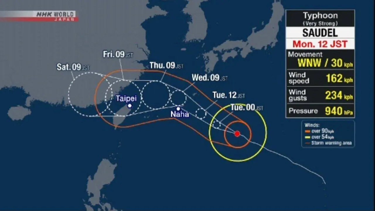
The regions of Okinawa and Amami, in southern Japan, are under high alert due to the imminent arrival of Typhoon Saudel, a highly intense storm expected in the coming days. Local meteorological authorities issued an urgent warning for the population to mobilize and adopt preventive measures due to the destructive winds and giant waves.
Trajectory and characteristics of Typhoon Saudel
Earlier this week, at 9 a.m. local time, Typhoon Saudel was spotted over the waters south of Japan. It was moving west-northwest at a speed of 35 kilometers per hour. The center of the storm registered an atmospheric pressure of 940 hectopascals, indicating its considerable strength.
More on this story: Typhoon Saudel unleashes destructive floods across southeast China, displacing hundreds of thousands
Winds near the center of the typhoon reached 162 kilometers per hour, with gusts that could reach 234 kilometers per hour. Within a radius of 165 kilometers from its center, winds were already exceeding 90 kilometers per hour, posing a significant danger.
Intensification of winds and risk of destruction on Japanese islands
The Japan Meteorological Agency’s forecast indicates that the typhoon will continue its westward movement. It will approach Okinawa Prefecture and the Amami region of Kagoshima Prefecture throughout this week. Winds are expected to begin gradually increasing from the beginning of the week in Okinawa, with maximum sustained gusts of 82.8 kilometers per hour expected in the Daitojima region.
On days of greatest impact, winds are expected to intensify quickly. Projections indicate that maximum sustained winds could reach 144 kilometers per hour in Okinawa and Amami. The gusts, considered the most dangerous, could reach 216 kilometers per hour in Okinawa Prefecture and 198 kilometers per hour in Amami. According to meteorological authorities, the strength of these winds is enough to cause the destruction of homes.
Full coverage: Latest News (EN)
Severe impact on the sea and rain
In addition to the extreme winds, Typhoon Saudel will bring extremely rough seas with strong waves. At the beginning of the week, waves of up to 7 meters were forecast for Okinawa.
- Projected waves:
- * Okinawa: up to 11 meters
* Amami: up to 10 meters
The expectation is that the rains will become more intense. In some areas of Okinawa and Amami, up to 150 millimeters of precipitation may occur over the next 24 hours, increasing the risk of flooding and landslides.
Slow Displacement and the Importance of Continuous Preparation
A factor that worsens the situation is the slow movement predicted for Typhoon Saudel. This characteristic indicates that the storm’s effects are likely to be prolonged, exposing affected regions to an extended period of severe weather conditions. The persistence of violent winds and high waves requires the population to remain on high alert.
Authorities reiterate the importance of preventive measures taken in advance to minimize risks and ensure the safety of residents in the face of the approaching threat. Preparation for the storm must be ongoing, following updates to weather warnings.
More news in Latest News (EN)
See more → Workplace ChatGPT starts copying individual writing stylesTop Ukrainian prosecutor resigns following probe into vast illegal call center network schemeCalls intensify for Australia to assert foreign policy independence over extensive US military presenceSaxony-Anhalt results underscore growing momentum for European far-right parties ahead of key votesJulia Louis-Dreyfus reveals intense creative clashes shaped iconic sitcom ‘Seinfeld’s’ groundbreaking humorU.S. forces dismantle sophisticated floating drug refueling station tied to Ecuadorian narco-terror groupGiants make unexpected roster move, release longest-tenured player Darius Slayton as Harbaugh era beginsEiffel Tower closure sparks outrage as staff protest gender segregation during VIP religious group visitCanada activates massive tariffs on American imports reaching C$27.6 billion, intensifying cross-border trade spatAfD’s near majority in Saxony-Anhalt state vote triggers widespread concern across GermanyPromotores desistem de apelo sobre confissão de Khalid Sheikh Mohammed para garantir julgamento em 2028Ejection of eight fans from Portland Thorns game sparks debate over free speech and stadium rules
More news on Mix Vale
- 1PlayStation 6 component bills surge to $960 amid memory crunch
- 2Rockstar North adds canine waste throwing to GTA 6 world
- 3Rockstar North details dog mechanics and street combat in GTA 6
- 4Corporate ChatGPT users gain custom text style replication
- 5Christine Taylor detalha pedido de emagrecimento para interpretar Marcia Brady em filme clássico dos anos 90
- 6Investigators retrieve flight recorders after deadly Amazon cargo plane overruns Miami runway, killing five
- 7NSW Greens lawmaker urges federal party to support koala park carbon credit deal amid internal rift
- 8Georgetown students reportedly plan controversial lookalike contest marking conservative activist’s assassination
- 9Southeastern conference dominates opening week with perfect 16-0 record, challenging Big Ten supremacy
- 10Disputa em lanchonete Jimmy John’s termina com menina de 14 anos baleada na perna em St. Louis