
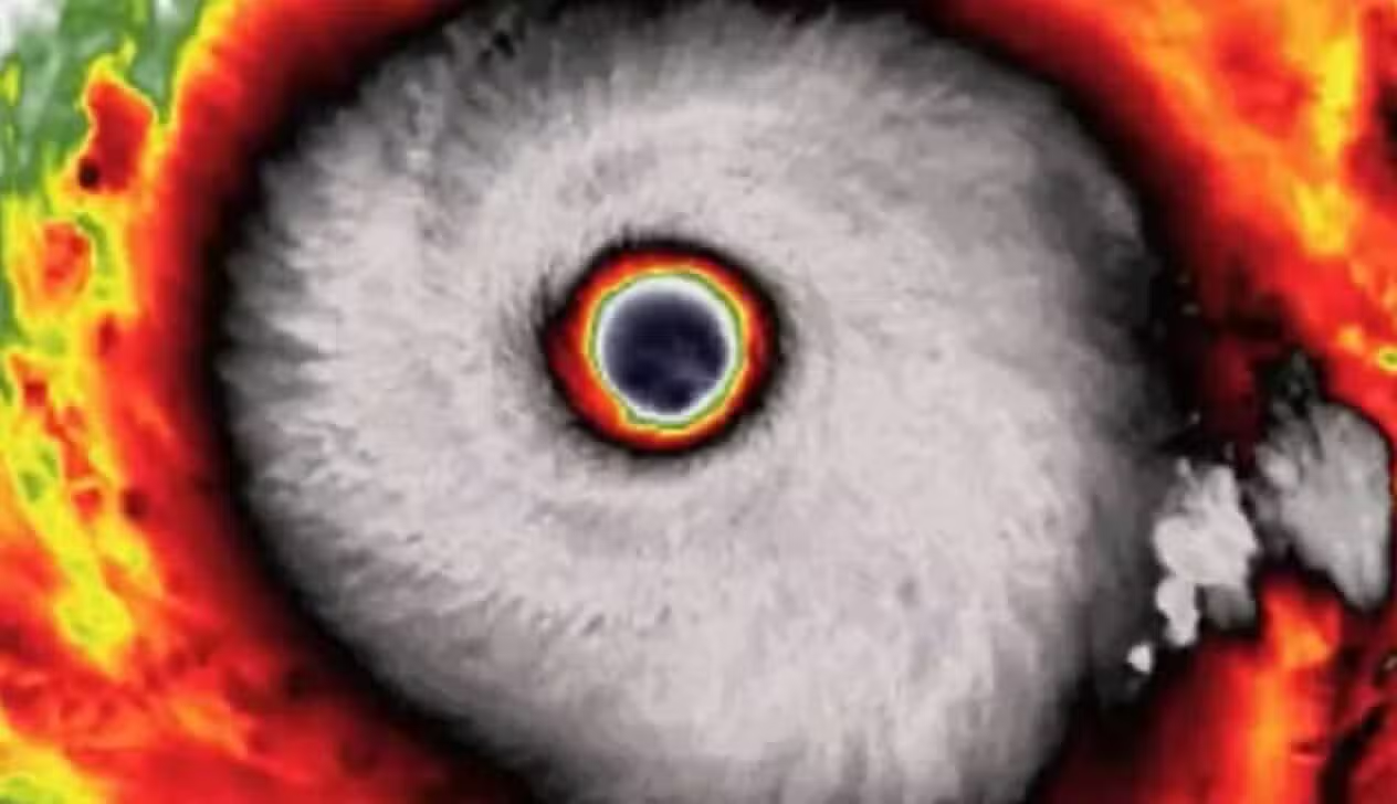
Peak sustained winds of 296 km/h (185 mph) have made Super Typhoon Champi the strongest tropical cyclone on Earth in 2026. The storm reached Category 5 status—the highest tier on the Saffir-Simpson hurricane wind scale—between Tuesday (20) and Wednesday (21), generating estimated gusts of up to 361 km/h as it tracks across the Western Pacific Ocean toward Taiwan, the Philippines, mainland China, and Japan.
Emergency management agencies across East Asia have issued weather warnings and ordered preventive maritime shutdowns ahead of the system’s arrival. Estael Sias, a meteorologist and managing partner at the Brazilian weather agency MetSul Meteorologia, outlined the timeframe for the storm’s direct impact on the island territories. “The forecast indicates that the period of closest approach may occur between Friday (23) and Saturday (24),” Sias said.
Coastal evacuations, suspended ferries, and military adjustments across Asia
In Taiwan, where Taipei Mayor Chiang Wan-an oversees municipal preparations in the capital, emergency monitoring is focused on torrential rainfall, destructive gales, and towering storm surges.Taiwan’s Central Weather Administration indicated that maritime and land warnings are under evaluation as the cyclone nears the island, while Taipei officials assess potential closures of schools, public offices, and financial markets. According to Sias, the severity of the damage will depend on local topography: “Northern and eastern Taiwan are among the areas that could face the most significant impacts.”
Along the eastern seaboard of mainland China, China’s National Meteorological Centre maintained a blue typhoon warning—the base tier of its four-level alert system—covering the municipalities of Shanghai and Xiamen as well as the provinces of Fujian and Zhejiang. In Zhejiang, provincial authorities began preparations on Wednesday (21) to evacuate vulnerable residents, including senior citizens, pregnant women, and people with disabilities. Local officials also suspended 36 passenger ferry routes, halted work on 223 marine construction projects, closed coastal tourist sites, and ordered fishing vessels in neighboring Fujian to return to port.
In the Philippines, where the cyclone is tracked locally under the name Rosal, the Philippine Atmospheric, Geophysical and Astronomical Services Administration (PAGASA, the country’s national weather bureau) kept Tropical Cyclone Wind Signal No. 2 in effect over the Batanes archipelago. The official advisory warns of coastal waves reaching up to 10 meters in the northern Philippines and accumulated rainfall exceeding 200 millimeters, elevating the risk of flash floods and landslides in saturated mountain terrain.
Severe weather across the Western Pacific also disrupted regional defense schedules. United States and Japanese armed forces scaled back operations during the joint Keen Sword military exercises—where Major Ephesian Poisette serves as military spokesperson—due to deteriorating navigation and flight conditions within the training zone.
Day-by-day progression of the cyclone across the Western Pacific
The meteorological system’s trajectory across the ocean follows a multi-day schedule of intensification and regional alerts across East Asia:
- Sunday, October 18, 2026: The typhoon passes near the United States territory of Guam in the Mariana Islands, displaying a well-formed eye structure on weather radar.
- Tuesday, October 20, 2026, at 18:00 UTC: The cyclone hits its peak sustained wind speed of 296 km/h (185 mph), with satellite imagery showing a clear eye approximately 70 kilometers wide.
- Wednesday, October 21, 2026: Governments in China, Taiwan, and the Philippines activate weather alerts, organize coastal evacuations, and suspend maritime operations as winds near the center moderate to 245 km/h (152 mph).
- Friday, October 23, 2026: The forecast window opens for the storm’s closest pass near Taiwan and the Sakishima Islands in Japan’s Okinawa Prefecture.
- Saturday, October 24, 2026: Severe weather conditions persist across northern and eastern Taiwan as the system tracks near the eastern coastline of mainland China.
- Sunday, October 25, 2026: The system is projected to reach main islands in western Japan, where the Japan Meteorological Agency classifies it locally as Typhoon No. 30.
How Super Typhoon Champi compares to Hurricane Polo during the 2026 El Niño
Super Typhoon Champi is the fourth Category 5 cyclone of the season in the Western Pacific and the seventh worldwide in 2026. By reaching 296 km/h, it surpassed Eastern Pacific Hurricane Polo, which previously held the annual global wind speed record with sustained winds of 285 km/h. However, Hurricane Polo still holds the 2026 record for the lowest central atmospheric pressure at 892 hectopascals (hPa, the international unit for measuring atmospheric pressure), compared to the 895 hPa recorded at the center of Champi.
Learn more: Hybrid vehicle imports to the EU hit 350,000 annual cap as China cuts tariffs and speeds rare earth licenses
Within the Western Pacific basin, the 2026 typhoon season produced three other major cyclones that fell short of Champi’s peak wind velocity. Those earlier storms include Super Typhoon Sinlaku, which reached sustained winds of 285 km/h in April; Super Typhoon Bavi, which also peaked at 285 km/h in July; and Super Typhoon Dolphin, which recorded maximum sustained winds of 267 km/h before striking Okinawa and Zhejiang in August.
Champi’s rapid intensification over open water was fueled by sea surface temperatures near 30°C, high atmospheric moisture, and low vertical wind shear—a meteorological state in which wind speed and direction vary minimally with altitude, allowing a cyclone’s vertical structure to expand without being torn apart. Satellite measurements during its peak showed convective cloud tops dropping to temperatures of -80°C surrounding a dry central eye spanning roughly 4,000 square kilometers.
These ocean conditions align with a period of heightened cyclonic activity driven by the El Niño climate phenomenon. “El Niño modifies atmospheric circulation and oceanic conditions, influencing cyclone activity across different regions,” Sias said. While the warming pattern typically suppresses hurricane formation in the Atlantic Ocean, it increases the frequency and intensity of severe storms across the Pacific basin.
Diverging forecast tracks and flight cancellations ahead of arrival in Japan
Forecasters have not yet confirmed whether the center of the cyclone will make direct landfall. Computer weather models remain split between two primary scenarios: one in which the core strikes eastern Taiwan before crossing the Taiwan Strait for a secondary landfall in China’s Fujian province, and another in which the storm executes a northeastward curve over open water, skirting the Chinese mainland entirely.
Regardless of the exact path, aviation authorities and carriers have already begun adjusting schedules across the region. Aviation data platform VariFlight listed Shanghai Pudong, Shanghai Hongqiao, Xiamen Gaoqi, Fuzhou Changle, Wenzhou Longwan, Ningbo Lishe, and Hangzhou Xiaoshan among the Chinese airports facing potential weather disruptions. In Japan, where reaching 30 named storms in a single year exceeds the annual average of 25 by 20 percent, carriers Japan Airlines and All Nippon Airways announced on Wednesday (21) the cancellation of multiple flights serving southern airports as Okinawa braces for rough seas and winds of up to 216 km/h.
As the cyclone moves further north over the coming days, it is expected to encounter cooler waters and stronger wind shear, causing it to weaken to a Category 4 or Category 3 system while retaining the capacity to generate destructive gusts and heavy flooding. Current projections indicate that Champi will arrive in western Japan on Sunday, October 25, 2026, downgraded to a severe tropical storm.