

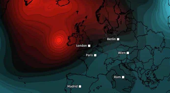
A powerful storm is currently forming over the Atlantic, threatening Europe with its intense impact by the end of this week. Experts are closely monitoring its development, which has already been classified as a bomb cyclone due to the rapid drop in atmospheric pressure. As the system approaches, it is expected to bring winds reaching 200 km/h to the coasts of Ireland and Britain, posing a significant threat to infrastructure and safety.
The first storm’s core pressure is predicted to drop an astonishing 44 hectopascals (hPa) within just 24 hours, far surpassing the 24 hPa threshold required for a system to be classified as a bomb cyclone. This extreme weather phenomenon is set to hit its peak strength by Friday, impacting large swathes of the British Isles with potentially devastating consequences.
Meteorologists warn that the danger does not end with this storm. Another system with bombogenesis characteristics could follow early next week, further escalating concerns about the potential for widespread damage.
Understanding bomb cyclones: A phenomenon of rapid intensification
Bomb cyclones are extreme weather systems defined by their rapid intensification, marked by a significant drop in atmospheric pressure. The current system forming in the Atlantic exemplifies this phenomenon, with its core pressure plummeting far beyond the established criteria. Such events are not uncommon in winter months when the clash between cold Arctic air and warmer oceanic currents creates the perfect conditions for their development.
The term “bombogenesis” originates from the explosive nature of these storms, which often bring hurricane-force winds, heavy rainfall, and coastal flooding. While bomb cyclones typically affect regions bordering large bodies of water, their impact can extend far inland, disrupting transportation networks, power supplies, and daily life.
Expected impacts on the British Isles and Ireland
The storm forecasted for this Friday is expected to bring some of the highest wind speeds recorded this year. Coastal areas of Ireland and western Britain are at the greatest risk, with gusts reaching up to 200 km/h. Such winds can cause significant structural damage, uproot trees, and create hazardous conditions for travel.
Additionally, the system may bring heavy rainfall, leading to localized flooding in low-lying areas. Coastal communities are bracing for potential storm surges, which can exacerbate flooding and increase the risk of damage to properties near the shoreline.
Authorities across the affected regions have issued warnings, urging residents to prepare for potential power outages and disruptions to daily routines. Emergency services are on high alert to respond to incidents and provide assistance where needed.
Second storm on the horizon: Uncertainty and anticipation
Even as Europe braces for the first storm, weather models indicate the possibility of a second bomb cyclone forming early next week. With a predicted core pressure of 925 hPa, this system could become one of the most intense storms of the year. Meteorologists expect the system’s pressure to drop 34 hPa within 24 hours, triggering another bombogenesis event.
While the exact trajectory and impact of this second storm remain uncertain, early predictions suggest it could follow a similar path, affecting the British Isles and potentially other parts of Europe. The potential for back-to-back storms has heightened concerns about the cumulative impact on affected regions.
Key factors behind the formation of bomb cyclones
- Clash of air masses: Bomb cyclones form when cold Arctic air collides with warmer, moist air over the ocean, creating a steep temperature gradient.
- Jet stream dynamics: The polar jet stream plays a crucial role in steering these systems and intensifying their development.
- Oceanic heat: Warmer sea surface temperatures provide additional energy, fueling the rapid intensification of these storms.
- Pressure drop: The hallmark of a bomb cyclone is a pressure drop of at least 24 hPa within 24 hours, though the current system far exceeds this threshold.
Historical context and comparisons
Bomb cyclones have been responsible for some of the most severe weather events in recent history. Notable examples include:
- January 2018: A bomb cyclone brought record-breaking cold temperatures and snow to the eastern United States, disrupting travel and power supplies.
- December 2021: The Pacific Northwest experienced hurricane-force winds and heavy rainfall as a bomb cyclone swept through the region.
- October 1987: The “Great Storm” in Britain, while not technically classified as a bomb cyclone, had similar characteristics and caused widespread destruction.
The current storms forming over the Atlantic are being compared to these historical events, with the potential to set new records in terms of wind speed and pressure changes.
Preparedness measures for residents in affected areas
Authorities and emergency services are urging residents in the path of the storm to take precautionary measures, including:
- Securing loose objects around homes and properties to prevent them from becoming projectiles.
- Avoiding unnecessary travel during peak storm conditions.
- Stocking up on essential supplies, including food, water, and batteries.
- Ensuring backup power sources, such as generators, are operational.
- Staying informed through weather updates and emergency alerts.
The role of technology in monitoring and predicting storms
Advancements in meteorological technology have significantly improved the ability to track and predict bomb cyclones. Satellite imagery, radar systems, and computer modeling enable scientists to monitor the formation and evolution of these storms in real-time. These tools provide valuable data, allowing authorities to issue timely warnings and prepare for potential impacts.
One of the key challenges, however, remains the unpredictability of such systems. While forecasts have become more accurate, the rapid intensification of bomb cyclones can still catch communities off guard, underscoring the importance of preparedness.
Potential long-term impacts on Europe
The back-to-back bomb cyclones forecasted for the coming days highlight the increasing frequency and intensity of extreme weather events. While individual storms cannot be directly linked to climate change, the overall trend of more powerful and unpredictable weather systems is consistent with scientific predictions about the impact of global warming.
European policymakers and scientists are closely monitoring these developments, emphasizing the need for resilience and adaptation strategies. Investments in infrastructure, improved emergency response systems, and international cooperation are critical to mitigating the effects of such events on communities and economies.
Key points about the upcoming storms
- The first storm is expected to reach peak intensity on Friday, with wind speeds up to 200 km/h.
- A second storm, potentially even more powerful, may form early next week.
- Bombogenesis, or the rapid intensification of atmospheric pressure, is the defining feature of these storms.
- Coastal areas of Ireland and Britain are at the highest risk of wind damage, flooding, and storm surges.
- Residents are advised to take precautions and stay informed through official updates.
Broader implications for Europe’s weather patterns
The formation of these bomb cyclones raises questions about the future of Europe’s weather patterns. As climate change continues to influence global systems, the region may face more frequent and intense storms, necessitating greater investment in climate resilience and disaster preparedness.