Cyclone SP: cold front generates gusts of 100 km/h in the Southeast and impacts in the Midwest


An extratropical cyclone forms in the south of Brazil this Friday (7) and advances towards the Southeast, with wind gusts that can exceed 100 km/h in areas of Rio Grande do Sul and São Paulo. The phenomenon, associated with a cold front, is completely organized at the end of the night between RS and Santa Catarina, moving towards the coast of Santa Catarina in the early hours of Saturday (8). Civil Defense issues warnings for the risk of tornadoes in the Northwest and North of Rio Grande do Sul, as well as severe storms in São Paulo.
The system reaches the sea towards the coast of São Paulo and Rio de Janeiro during Saturday, with an estimated center between Rio de Janeiro and Espírito Santo on Sunday (9). Impacts include damage to structures, kiosk coverings and small and medium-sized vessels in coastal regions.
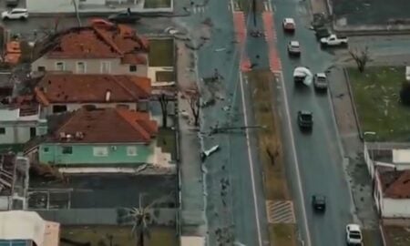
- Forecast indicates winds above 70 km/h capable of causing tree falls and power outages.
- Gusts exceeding 100 km/h increase the risk of roof collapses in urban areas.
- Instabilities also affect the Central-West, Northeast and North with intense rains.
Cyclone formation
The cyclone begins its organization throughout this Friday in the South. It moves quickly towards the ocean near Santa Catarina and São Paulo.
Climatempo predicts intensification at the end of the night. The phenomenon gains strength with the associated cold front.
Civil Defense Alerts
Gaúcha authorities highlight the possibility of tornadoes in the afternoon in the Northwest and North regions. Municipalities prepare teams for incidents.
In São Paulo, the alert covers several cities with forecasts of heavy rain, lightning and hail. A Crisis Office has been activated for ongoing monitoring.
The North Coast of São Paulo records potential for winds of 115 km/h. Point damage increases at high speeds.
Regional impacts
In the Central-West, intense showers occur in the south of Mato Grosso do Sul and north of Goiás. High accumulations of rain are expected in the afternoon.
The Northeast faces instability in the southwest of Bahia, south of Piauí and west of Maranhão. Moderate rainsstrong ones predominate in these areas.
In the North Region, the center-south of Pará, eastern Amazonas, Roraima and Tocantins receive significant volumes. Weather instability persists throughout the day.
Weekend forecast
The cyclone remains at sea on Saturday, affecting the southeast coast. The wind continues with the potential for damage to kiosks and boats.
On Sunday, the center of the system is positioned between RJ and ES. Effects gradually diminish in continental areas.
Prevention measures
People should avoid wooded areas during strong winds. Vehicles cannot park under trees to prevent accidents.
Loose objects on balconies must be collected. In lightning storms, avoid metal structures and contact with water.
Never cross flooded areas on foot or in a vehicle. Downed live wires require staying inside the car until help is available.
In emergencies, call Civil Defense on 199 or Firefighters on 193. Coastal municipalities reinforce response teams.
Detailed trajectory
The phenomenon begins in RS and migrates to the ocean. In the early hours of Saturday, it approaches Santa Catarina.
During the morning and afternoon, it advances parallel to the coast of São Paulo. Throughout the day, it influences Rio de Janeiro.
The extratropical center stabilizes on Sunday in the high seas. Direct influence is reduced on the southeast beaches.