Magnitude 4.2 earthquake shakes Great Falls, Montana, causing tremors in several cities
A 4.2 magnitude earthquake struck west of Montana on Thursday afternoon, triggering tremors that were felt across a wide area of the region. The earthquake, confirmed by the Serviço Geológico of the Estados Unidos (USGS), drew attention to local geological activity.
The event occurred at around 12:41 pm local time, and its epicenter was strategically located close to important landmarks. The moderate magnitude was enough to generate perceptions in cities far from the main point of the shaking.
Local authorities and seismic monitoring bodies are assessing the consequences of the quake, although there were no immediate reports of significant damage. The population was advised to follow safety recommendations in cases of seismic activity.
Details of the epicenter and depth of the shaking
The epicenter of the earthquake was precisely determined to be approximately 12 kilometers, equivalent to 7.45 miles, northeast of Base Aérea of Malmstrom. Essa proximity to a military installation highlights the importance of continuous monitoring of seismic activity in the area, which can have broader implications.
According to the detailed information provided by the USGS, the estimated depth of the quake reached about 6.21 miles below the earth’s surface. Essa relatively shallow depth contributed to the tremors being noticeable over a wider area, since the seismic energy dissipated less before reaching the surface.
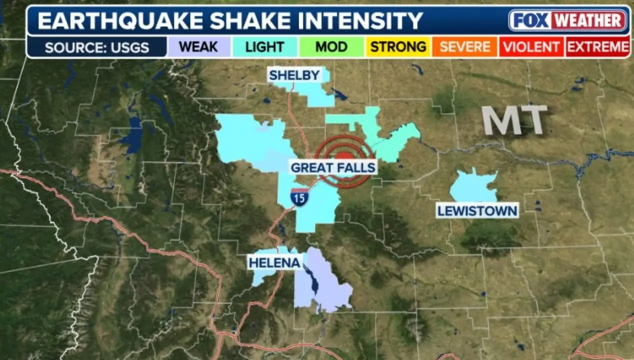
Propagation of tremors in Montana
The seismic wave generated by the magnitude 4.2 earthquake propagated beyond the epicenter, resulting in reports of tremors in several locations in the state of Montana. Próximo to the central point, in the city of Great Falls, which is about 18 kilometers away, the tremors were described as moderate, causing a slight scare among residents and workers in the region. The intensity felt progressively decreased with distance, but it was still enough to alert the population in more distant areas.
In a wider radius, the city of Shelby, located to the north and approximately 85 miles from Great Falls, also recorded light tremors. The state capital, Helena, which is a considerable distance from the epicenter, also noticed the passage of the seismic waves, with reports of light tremors that, although they did not cause panic, were noticed by the population. Esses reports demonstrate the ability of a moderate magnitude earthquake to affect a vast geographic area, requiring civil defense and seismic monitoring bodies to always be alert to the spread of such events.
History of seismic activities in the region
Montana, located in the western region of Estados Unidos, has a geological history that includes the occurrence of earthquakes. The area is subject to seismic activity due to its proximity to Cordilheira and Rochosas and the presence of several active geological faults, which are the result of millions of years of tectonic movements. Embora is not as frequent as in other regions of Círculo of Fogo of Pacífico, seismic activity in Montana is a constant reality.
Smaller magnitude events, such as the recent one, are relatively common and serve as reminders of the dynamic nature of the Earth’s crust. The USGS and other institutions continually monitor these activities to understand patterns and potential risks. Compreender This history is fundamental for urban planning and emergency preparedness in the region.
Continuous monitoring and risk assessment
After the earthquake was recorded, the Serviço Geológico and Estados Unidos teams intensified monitoring of the area to detect possible aftershocks, which are secondary tremors that can occur after the main shock. Essa surveillance is crucial to assess soil stability and identify any additional risks to nearby communities. Modern technology allows for rapid response in the collection and analysis of seismic data.
Leia Também


In addition to real-time monitoring, seismology experts are beginning to carry out in-depth analyzes of the event, studying the depth of the fault, the type of movement and the energy released. Esses studies are important to improve forecast models and understanding of geological phenomena in the region. Collecting detailed data contributes to a more accurate map of seismic activity.
Initial reports indicate that, fortunately, no significant damage occurred as a result of the earthquake. However, the full assessment is still ongoing, and teams of engineers and technicians can be mobilized to inspect critical infrastructure, such as bridges, buildings and roads, ensuring the safety of the population and the integrity of constructions in the affected area.
Safety Measures and Essential Preparedness
The occurrence of earthquakes, even those of moderate magnitude, serves as an important reminder of the need for preparation and knowledge of safety measures. Simple Ações can make a difference in individual and collective protection during a seismic event. It is essential that residents of regions susceptible to tremors are familiar with emergency protocols to minimize risks.
Civil security experts recommend some basic attitudes:
- Crouch, Cobrir and Segurar:When you feel a tremor, your first action should be to crouch on the floor, cover your head and neck with your arms and seek shelter under a sturdy table or in a corner of the wall.
- Move away from windows and objects:Evite stay close to windows, mirrors, shelves and other objects that could fall and cause injury.
- Emergency plan:Tenha a family emergency plan, including safe meeting points and first aid kits.
- Find out:Mantenha stay up to date with information from local authorities and safety recommendations after an earthquake.
Perspectives and future actions
Despite the absence of immediate reports of damage, authorities remain attentive to the situation. Infrastructure assessment can take days or even weeks, ensuring that all structures are safe. Collaboration between state and federal agencies is essential to consolidate information and plan preventive actions.
This event reinforces the importance of continued investment in seismic monitoring systems and public education on how to act in the event of tremors. Awareness and preparation are the best tools to mitigate the impacts of future geological events. Communities are encouraged to review their emergency plans periodically.
The experience lived in and around Great Falls may also motivate new research into the specific geological faults of Montana. Entender improving the dynamics of these faults can offer valuable insights for the construction industry and for the development of more effective warning systems. Science plays a crucial role in protecting lives and property.
This Thursday’s event at Montana serves as a vivid reminder of the strength of nature and the need for resilience. Although the magnitude was not catastrophic, the tremor was felt and generated attention, promoting a sense of vigilance and appreciation of safety measures. The community demonstrates its ability to respond and adapt to such natural occurrences.