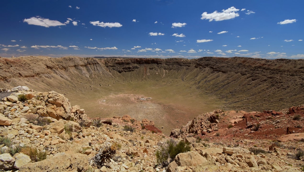
A geological formation that originated approximately 50,000 years ago continues to provide essential data to the global scientific community about the dynamics of the solar system. Localizada in the arid landscape of Arizona, in Estados Unidos, the structure is more than 1,200 meters in diameter and reaches a depth of 210 meters. The site represents one of the best preserved impact sites for celestial bodies in the world, functioning as a natural laboratory for geologists, astronomers and researchers from different areas.
The event that caused the depression involved a meteorite composed predominantly of nickel and iron, with an estimated diameter of around 50 meters. The celestial body reached the earth’s surface at a speed that varied between 12 and 20 kilometers per second. The energy released at the moment of the collision was equivalent to several megatons of TNT, which resulted in the instantaneous vaporization of a large part of the space object and the rocks present at the exact point of the collision.
The shock wave generated by the impact carved the circular depression visible today, displacing millions of tons of limestone and sandstone. The magnitude of this physical force is comparable to large-scale nuclear detonations, establishing the area as a key reference point for understanding catastrophic events that have shaped the planet throughout its geological history.
Ongoing investigations at the site focus on specific areas of geoscience and astrobiology. Field and laboratory work includes the following main approaches:
– Análise detailed effects of shock metamorphism on local minerals and rocks.
– Avaliação of the impact of cosmic events on the evolution of the Earth’s biosphere over the millennia.
– Obtenção of comparative structural data for the study of craters located on other planets in the solar system.
Geological preservation in the American desert
The uniqueness of the structure at Arizona lies in its almost intact state of conservation, a rare factor in terrestrial geology. Diferentemente Of many other similar formations that have suffered severe erosion processes or been altered by continuous tectonic activity, this site has retained its original characteristics remarkably.
The region’s predominantly arid climate and the absence of large bodies of water nearby have acted as conservative agents over the millennia. Essa environmental stability allows scientists to accurately examine exposed rock layers and minerals that have been directly altered by thermal and mechanical shock.
Structure identification history
The true origin of depression was the subject of intense academic debate during the first decades of the 20th century. Inicialmente, most geologists attributed the formation to volcanic processes, a standard theory at the time to explain large circular cavities on the Earth’s surface.
Mining engineer Daniel Barringer was primarily responsible for contesting the predominant view of the scientific community at the time. Ele devoted substantial financial resources and years of work to the search for physical evidence, such as meteorite fragments and shock minerals, that could prove the extraterrestrial impact theory.
The insistence on drilling the ground in search of the main meteoric body paved the way for the definitive recognition of the site as a genuine impact crater. The confirmation reconfigured global understanding of the dynamics of collisions in Terra and served as a basis for identifying other similar structures around the world.
Mineral evidence in exposed rocks
Geological surveys carried out on the crater walls revealed the presence of specific minerals, such as coesite and stishovite. Estas are forms of silica that require extreme pressure and temperature conditions to crystallize, characteristics unique to high-speed impacts.
The discovery of these elements was the determining factor in validating the meteoric origin of the structure. The presence of coesite and stishovite allowed scientists to definitively rule out the hypothesis of volcanic formations, establishing a new parameter for identifying impact sites.
Thorough analysis of the exposed rocks makes it possible to accurately reconstruct the sequence of impact events. Researchers are able to map from the moment of material ejection to the formation of complex breccia structures, treating each sample as a temporal record of the collision conditions.
The site’s internal topography, characterized by its almost perfectly circular shape and the ring of ejected rocks around the edge, provides a classic model of morphology. Esta structural characteristic is widely used in the development of computational models for the study of planetary surfaces.
Dynamics of collisions in the solar system
Experts in impact geology point out that events of this nature shaped the Earth’s crust, atmosphere and ecosystems in profound ways. Large-scale Colisões have the ability to drive drastic climate change and trigger mass extinctions, altering the biological course of the planet. A documented example is the event that occurred around 66 million years ago, in the transition between the periods Cretáceo and Paleogeno, when an asteroid hit Península of
Although formation in Arizona occurred on a significantly smaller scale, it acts as a microcosm to illustrate the physical mechanisms behind extinction events. Fenômenos how massive shock waves, gigantic tsunamis, dust clouds that block solar radiation, and subsequent climate changes can be modeled from data extracted from the American desert. The information collected provides an essential empirical basis for modern geoscience to project the effects of impacts of different magnitudes.
Application of mapping technologies
The introduction of advanced technologies, such as mass spectroscopy and X-ray microanalysis, has provided an unprecedented level of understanding about the materials involved in the collision. Essas analytical tools allow scientists to identify unique chemical and structural signatures in nanometer-sized rock fragments. The ability to examine samples at this scale reveals the exact composition of the original impactor body and the precise pressure conditions to which the soil was subjected. Além In addition, modern geophysical imaging techniques enable three-dimensional visualization of underground structures, mapping the distribution of impacted materials far below the visible surface and revealing the true complexity of the affected area.
Space mission training
The North American space agency uses the geological site as an official training ground for astronauts. The morphological similarities with the surfaces of Lua and Marte make it an ideal environment for preparing teams, focusing on recognizing extraterrestrial geological features and improving sample collection techniques for future interplanetary missions.
Monitoring objects close to Terra
The data extracted from the crater transcends historical study and applies directly to contemporary planetary defense programs. Agências spacecraft intensified monitoring from Objetos Próximos to Terra (NEOs), using impact metrics from Arizona to calibrate warning systems and assess potential damage.
Terrestrial and orbital telescopes continuously track asteroids and comets, calculating trajectories with high precision. International collaboration is based on knowledge acquired from preserved impact sites to develop risk mitigation strategies, ensuring the prior identification of celestial bodies that could pose a danger of collision with the planet.