Supertyphoon Sinlaku hits Northern Mariana Islands with winds of 230 km/h and heavy rain

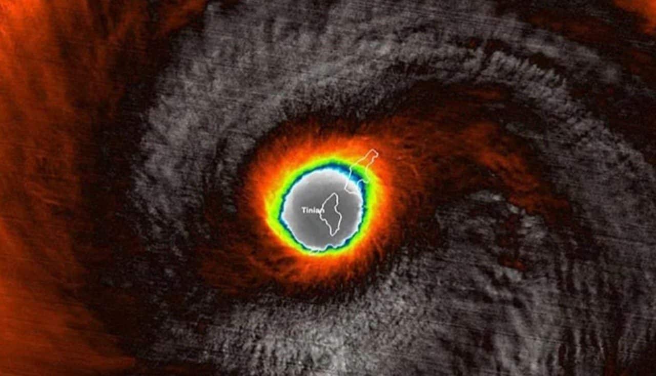
Super Typhoon Sinlaku made landfall at Ilhas Marianas on Tuesday, April 14, 2026, with sustained winds of up to 230 km/h. The high-intensity meteorological phenomenon, which passed directly over Tinian and Saipan, caused interruptions and warnings for residents of the American territory. Embora weakened before impact, the effects remain severe, with heavy rains and high waves expected.
Joint Typhoon Warning Center confirmed the intensity of the winds at the time the eye of the storm touched down at 10:30 a.m. (Estados Unidos Eastern Daylight Time). The central atmospheric pressure was estimated at 920 millibars (mb) by Japan Meteorological Agency, a level that indicates the strength of a cyclonic system of great magnitude. Autoridades Locations and climate monitoring agencies continue to monitor the evolution of the typhoon.
Initial impact on main islands
The passage of super typhoon Sinlaku concentrated its most intense effects on Tinian and Saipan, two of the three main islands of the Marianas archipelago of Norte. Estas islands, which are part of the region’s volcanic arc, felt the full force of the winds and the first showers of rain. Imagens published by residents on social media shows the intensity of the winds, with structures shaking and trees being knocked down. Emergency centers were activated, and the population was advised to seek safe shelter.
Despite the typhoon’s potency, the reduction in its rating in the 24 hours before impact was crucial to mitigating the most catastrophic damage. The initial phase was marked by a combination of strong winds and the beginning of precipitation, which quickly became intense. Equipes emergency response teams were on standby to assess the first damage as soon as conditions permitted. Communication on the islands was affected, but main radio and satellite networks remained operational to coordinate relief efforts.
Reclassification and reduction of damage potential
Initially, super typhoon Sinlaku had been classified as a Categoria 5 typhoon, the highest on the Saffir-Simpson scale, which measures the intensity of tropical cyclones. Contudo, in the last 24 hours before reaching Ilhas Marianas of Norte, the phenomenon underwent a significant weakening process. Esta change in classification was a partial relief, as, according to NOAA (National Oceanic and Atmospheric Administration), the damage potential was reduced by more than four times.
This mitigation, although it did not eliminate the risks, provided a less catastrophic scenario than initially predicted. Cientistas atmosphericists explained that interaction with dry air masses and variations in sea surface temperature may have contributed to this loss of strength. Mesmo Thus, a typhoon with winds of 230 km/h and central pressure of 920 mb still represents a serious threat, capable of causing widespread destruction to infrastructure and vegetation. Surveillance, therefore, remained at maximum level, with emergency alerts active throughout the territory. Preparing the population in advance for a category 5 scenario was essential so that existing structures could better resist the impact.
Forecasts of rain, waves and other risks
The Ilhas Marianas of Norte face, in addition to the winds, a projection of extremely heavy rain and giant waves. Dados and Yale Climate Connections already indicate the record of rain showers that promise to continue for several hours after the eye of the typhoon passes. The amount of expected precipitation is one of the points of greatest concern, due to the risk of flooding and landslides.
National Weather Service Guam issued specific warnings about hydrological and coastal conditions, predicting a challenging scenario for the coming days.
- Accumulated from Chuva:Forecasts indicate that accumulations could vary between 380 mm and 630 mm in some areas, a volume that far exceeds the natural drainage capacity of the soil and urban systems.
- Waves:São waves of 6 to 9 meters high are expected at the coast, posing a significant danger to vessels and low-lying coastal areas, with a risk of storm surge and erosion.
- Winds:Embora the peak has already passed, strong winds and gusts will persist for a while, causing further damage and complicating rescue and assessment operations.
- Tides of Tempestade:The risk of storm surges, which are abnormal rises in sea level caused by low pressure and typhoon winds, is also considered, which could worsen coastal flooding.
- Cuts from Energia:The interruption in electricity supply and communications is widespread, impacting routine and emergency operations in the region.
The combination of these factors requires residents to remain in safe places and follow the authorities’ guidelines, even after the apparent decrease in wind intensity.
Emergency operations and federal support
With Super Typhoon Sinlaku underway, Ilhas Marianas authorities, in coordination with Estados Unidos federal agencies, activated large-scale contingency plans. Agência Federal of Gerenciamento of Emergências (FEMA) was already mobilized even before the direct impact, positioning supplies and response teams in strategic areas for rapid action. As Forças Armadas from the US also prepared to provide logistical and humanitarian support if necessary.
Designated shelters were opened and received significant numbers of people, especially those residing in coastal areas or in more vulnerable housing. The immediate focus of operations was to ensure the safety of the population, monitor weather conditions and plan damage assessments. Radio and satellite communications were prioritized for emergency responders. The mobilization of federal resources highlights the seriousness of the threat and the importance of coordination between levels of government to mitigate the impacts of a natural disaster of this magnitude.
Monitoring and future trajectory of the system
After the initial impact on Norte, the tendency is for super typhoon Sinlaku to continue its trajectory, but with an expectation of gradual weakening. Meteorological projections indicate that the system should change its route to Norte and Nordeste throughout the week. Essa change of direction is a positive factor, as it reduces the risk of new direct impacts on other inhabited islands in the American territory, although the reach of winds and rain can still affect more distant regions.
Joint Typhoon Warning Center and Japan Meteorological Agency keep constant monitoring of Sinlaku, providing regular updates on its speed, direction, and remaining intensity. The decrease in the strength of the typhoon is a natural process that occurs as it moves away from warm waters and encounters less favorable atmospheric conditions for its support. The expectation is that, in the coming days, the super typhoon will lose its most severe characteristics, transforming into a tropical storm or even dissipating. Contudo, surveillance will persist until the phenomenon poses zero risk to navigation and local communities.