
NASA satellite records unprecedented images of giant tsunami in the Pacific


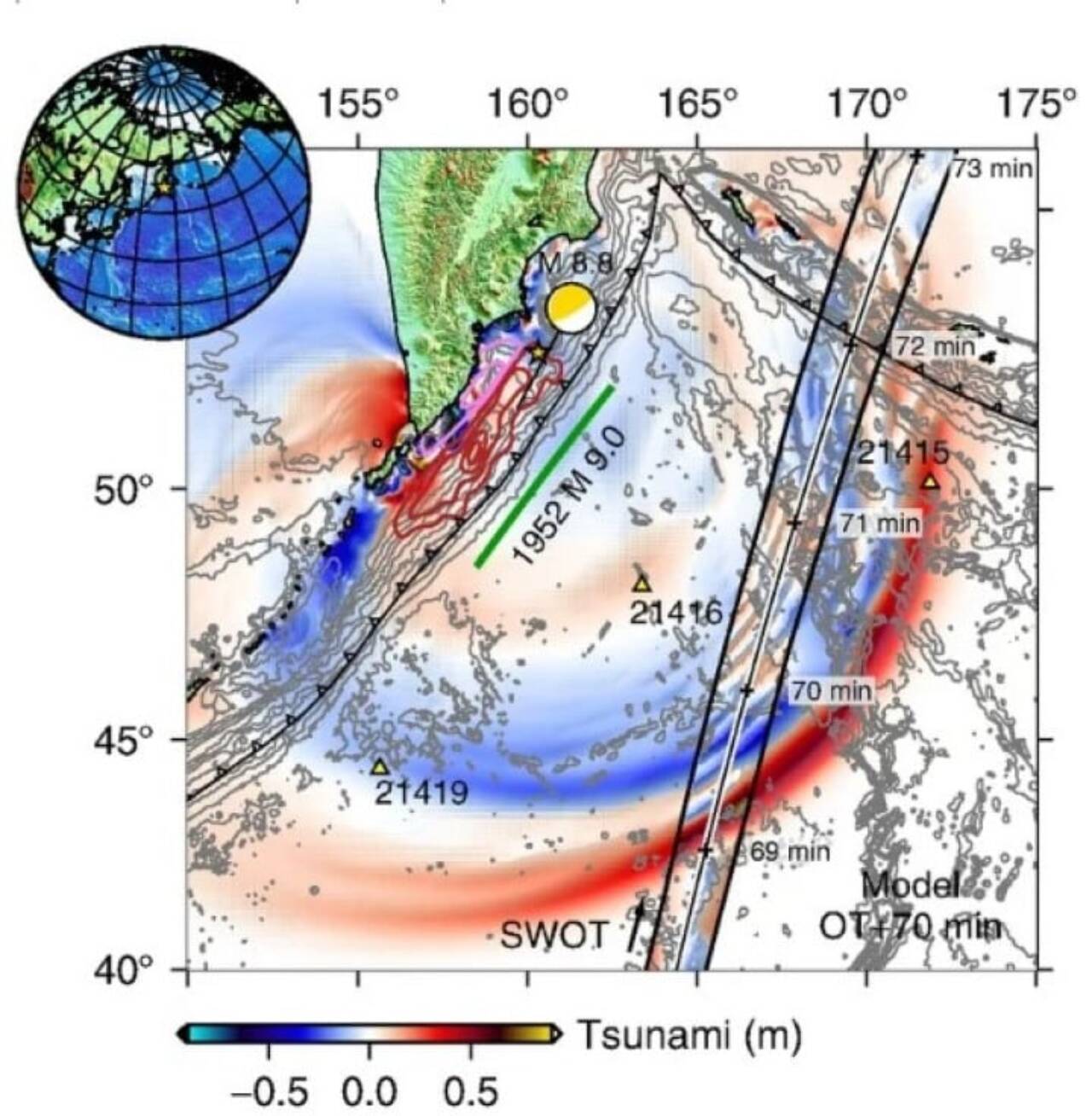
An 8.8 magnitude earthquake struck the Kuril-Kamchatka subduction zone on July 29, 2025. The tremor generated a tsunami that spread across the Pacífico ocean. The SWOT satellite, developed in partnership by NASA and the French space agency CNES, passed through the region and recorded the event in high resolution.
The measurements took place about 70 minutes after the tremor. The instrument mapped a 120-kilometer-wide strip of sea. The data shows a braided pattern of energy rather than a single, linear wave as predicted by classical models.
Wave Padrão challenges traditional theory
The spatial record revealed dispersive waves. The energy has split into major and minor components that travel at different speeds. Essa dispersion spread over hundreds of kilometers.
Cientistas adjusted the initial earthquake model. The length of the rupture increased from about 300 kilometers to approximately 400 kilometers along the fault. The event reactivated portions of the megafault associated with the great 1952 earthquake in the same region.
- SWOT captured ocean surface deformation in detail never seen before by satellite
- Boias DART records data only at isolated points in the ocean
- The new instrument offers a broad and continuous view of wave evolution
- Dispersion modulates the force that reaches distant ports and beaches
- Current Modelos may underestimate coastal energy variability
The tsunami proved to be less destructive than the one in 1952. The rupture occurred in deeper waters, which helped to dissipate some of the energy.
Satélite SWOT expands observation capabilities
SWOT was originally designed to measure water levels and ocean circulation. The flyby coincided with the tsunami and allowed the first detailed spatial record of a large event generated by a subduction zone.
Pesquisadores highlight that the tool works as a new observation instrument. Ela complements DART buoys and seismic records. Combining the data refined the understanding of the source of the tsunami.
Complete processing of satellite information takes five to ten days. Essa latency still limits immediate use in real-time alerts. Mesmo results therefore indicate potential for improving future predictions.
Estudo details dispersive behavior of waves
An article published in the journal The Seismic Record presents the findings. The analysis compares the SWOT images with established theories about ocean basin tsunamis. Instead of non-dispersive, predictable waves, the data shows complex internal structure.
The team corrected estimates about the earthquake. Dados from the satellite and buoys helped to better map the evolution of the rupture. The observed pattern suggests that dispersion influences the arrival time and strength of waves in different stretches of the coast.
Implicações for coastal security
The complexity revealed affects the way risk is assessed in coastal regions. The energy that is divided and spread can generate significant variations in the final impact. Portos and beaches receive different forces depending on the modulation of secondary waves.
Cientistas indicate that forecast models need to incorporate this variability. Observações like those in SWOT can contribute to more accurate systems. The record reinforces the importance of instruments that capture the ocean on broad scales and with high resolution.
The event occurred in an area known for intense seismic activity. Kamchatka is part of Cinturão of Fogo of Pacífico. Terremotos in this area have already generated historic tsunamis with transoceanic reach.
Detalhes spatial registration technicians
The satellite recorded the offshore wave field near Kamchatka. Measurements appear as data bands with variations in height from the sea surface. The width of 120 kilometers allowed us to see not only the main wave, but also the train of smaller waves that follow it.
Essa wide view differs from previous observations limited to narrow lines or fixed points. The instrument detected the wave geometry changing in space and time. The scattering creates an interlaced pattern that spreads across the Pacífico.
The data is still being explored by different teams. Eles opens the way for studies that integrate satellite altimetry with other monitoring methods. The focus now is to understand how to apply this information in warning scenarios and coastal defense planning.





