Strong tremor hits northeast coast of Japan and forces evacuation due to risk of giant waves


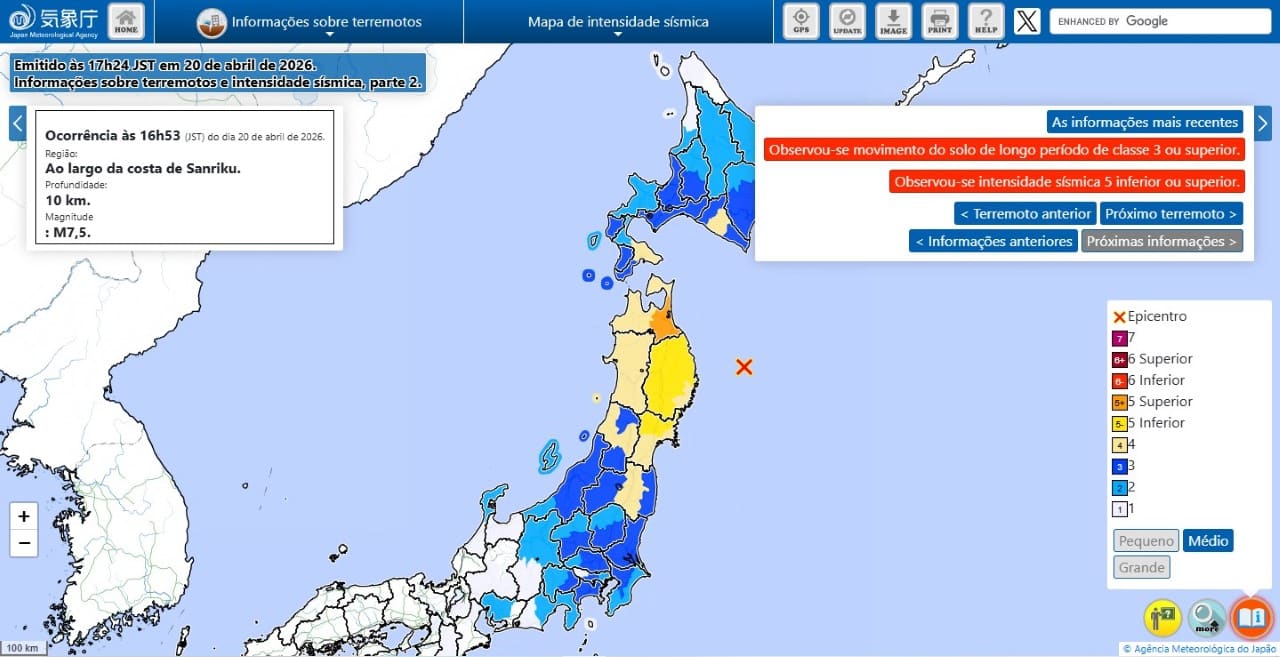
A strong 7.5 magnitude tremor struck the northeast coast of Japão on Monday afternoon. The shock occurred at exactly 4:53 pm local time. Japão’s Agência Meteorológica issued a tsunami warning shortly thereafter. The provinces of Iwate and Aomori have entered a state of maximum attention. The central coast of Pacífico on the island of Hokkaido also received the distress warning. Local Autoridades ordered the immediate departure of residents from low-lying areas. The main focus of rescue teams is to ensure the protection of coastal communities before large volumes of water arrive.
Epicentro in the ocean Pacífico triggers high-intensity tremors
The earthquake’s point of origin was detected around 100 kilometers off the coast of the city of Miyako. The depth estimated by seismologists was around 10 kilometers. Essa shallow feature amplifies the perception of movement on the surface. Moradores from the Tohoku region reported a tremor rated as 5 strong on the national seismic scale. The ground shook for tens of seconds in several municipalities. Prédios shook violently.
Emergency Equipes activated contingency plans in the city halls closest to the epicenter. The preliminary survey did not indicate fatalities in the first moments after the collision. Algumas old structures showed surface cracks. The rail transport service suffered preventive interruptions. Trens bullet stopped automatically thanks to motion sensors. Escolas and public offices have initiated security protocols. The government’s priority quickly shifted from tremor to maritime risk.
The mainshock reverberated hundreds of miles away. Habitantes from the metropolitan region of Tóquio also felt the vibrations slightly. Prédios highs in the capital shook slightly. Road and port infrastructure undergoes rigorous inspections. Engenheiros evaluates bridges and viaducts in areas of greatest impact. The supply of electricity and drinking water remains under constant monitoring by local concessionaires.
Chegada from first waves to ports demands immediate evacuation
The change in sea level became visible a few minutes after the earthquake ended. The first significant wave hit ports in the provinces of Iwate and Hokkaido. Gauges recorded a rise of 0.8 meters at the port of Kuji at around 5:34 p.m. The water advanced quickly. Outras coastal cities also documented the arrival of the oceanic phenomenon.
The port of Miyako recorded waves of 0.4 meters at 5:22 pm. The same value appeared on Urakawa’s instruments about an hour later. Locais as the port of Sendai and Soma recorded variations of 0.2 meters. The city of Hachinohe recorded 0.3 meters of elevation. The measurements confirmed the meteorological agency’s mathematical models.
The risk map covers very specific territorial strips along the northeast coast. The civil defense system delimited the most vulnerable sectors. Evacuation orders focused on the following geographic points:
- Costa of Pacífico of Aomori province at risk of flash flooding.
- Toda the coastal extension of Iwate province close to the epicenter.
- Faixa hub of Pacífico belonging to the island territory of Hokkaido.
Sirenes sounded uninterruptedly in the communities listed in the official notice. Veículos with loudspeakers walked the streets parallel to the beaches. Residents walked toward hills and tall buildings designated as vertical shelters. Government guidance prohibits returning to homes until the state of emergency is formally lifted. The sea retreats and advances unpredictably during these occurrences.
Continuous Monitoramento covers neighboring provinces and Japanese capital
The radius of attention extended beyond the high alert zones. Avisos secondaries encompassed the east and west coasts of Pacífico into Hokkaido. Mar’s margin from Japão at Aomori has also come on the radar of maritime authorities. Miyagi and Fukushima provinces have received caution notices. The expected volume of water in these areas is lower. The risk of dangerous currents, however, remains extremely high.
Tsunami dynamics involve multiple waves over several hours. The first rise rarely represents the maximum energy peak of the event. The ocean can experience severe oscillations long after the initial earthquake. Pessoas near rivers that flow into the sea are in extreme danger. Salt water often invades riverbeds with destructive force. Staying away from the margins is a basic rule of survival.
Estações tide gauges transmit data via satellite in real time to command centers. Meteorologists update forecasts with each new reading from underwater sensors. Emissoras television interrupted normal programming. Letreiros flashes on the screen indicate escape routes. Aplicativos cell phones trigger shrill sound notifications. The communication network serves as a vital tool to prevent human losses.
Histórico seismic region of Sanriku reinforces civil defense protocols
The coast of Sanriku rests on one of the most complex tectonic zones on the planet. The Pacífico plate dives under the Norte-Americana plate at exactly this latitude. Esse geological process of subduction accumulates a colossal amount of energy over the decades. The abrupt release of this tension results in violent earthquakes. The seabed undergoes instantaneous deformation. The water column above the geological fault moves and generates the tsunami.
Japão has a culture of prevention rooted in the population’s daily lives. Evacuation Simulações occur regularly in schools and businesses. Citizens know exactly which way to go when the earth shakes. The local architecture incorporates seismic damping technologies. Modern Prédios shake to dissipate shockwave energy. Rescue team response times have drastically decreased in recent decades.
Displacement coordination prioritizes vulnerable demographic groups in coastal cities. Idosos and children receive immediate assistance from neighbors and public agents assigned to the task. Pessoas with reduced mobility use pre-established routes and adapted transport vehicles. Japanese families prepare emergency backpacks months in advance. Esses survival kits contain bottles of drinking water, long-lasting dehydrated foods, flashlights with extra batteries, and continuous-use medications. Strict social organization prevents chaos in the streets during the crucial minutes of mass escape.
This Monday’s geological event once again tested the effectiveness of this complex civil protection mechanism. The ocean waves observed until the beginning of the night remained below the one meter mark in the vast majority of installed meters. The scenario, however, requires uninterrupted vigilance from security forces and the coast guard. The sea is home to physical variables that are impossible to predict with absolute accuracy through algorithms. The detailed monitoring work continues into the early hours of the morning in government control centers spread across the country.
The population remains sheltered in sports halls and community centers located on high ground. Voluntários distribute blankets and hot drinks to the temporarily homeless. The central government is in direct contact with the mayors of affected cities to coordinate the shipment of additional supplies. Helicópteros of the self-defense forces fly over the coastline looking for drifting vessels or infrastructure damaged by the force of the water. The routine of northeastern Japanese provinces will be altered until the tectonic fault is completely stabilized.