NASA and ESA records reveal accelerated advance of volcanic ash on the surface of Mars

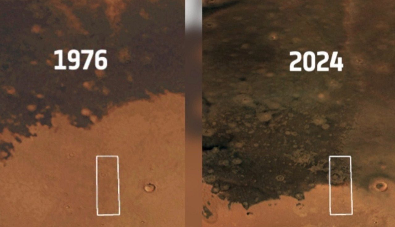
Recent Fotografias images captured by Agência Espacial Europeia and NASA satellites show a significant change in the landscape of the planet Marte. The dark material, identified as volcanic ash deposits, expanded considerably over the Martian surface in a time span of less than five decades. The scientists carried out a cross-referencing of visual data that compares historical records obtained by the orbiters of the Viking mission in 1976 with high-resolution images processed throughout 2024. Direct analysis of this photographic material proves that the dark spot took on much larger proportions than those previously mapped. The visual contrast generated by the new captures surprised researchers involved in orbital monitoring. The difference in land cover between the two periods leaves no room for doubt about the activity in the region.
The phenomenon attracts immediate attention from the international astronomical community due to the speed of the transformations. In terms of planetary geology, structural changes usually require millions of years to become noticeable to observation instruments. The rapid advance of dark ash over the traditional light and yellowish sands of Marte breaks this temporal paradigm abruptly. The discovery shows a world much more active than ancient astronomy manuals suggested. Especialistas from several research centers are now devoting efforts to understanding the exact mechanisms that drive these surface dynamics. Continuous observation of the site has become a priority for space agencies.
Detalhes topographic and impact crater
Visual documentation from 1976 showed the volcanic deposits concentrated in a restricted area, with little dispersion across the adjacent terrain. The equipment of the time, although revolutionary for the period, registered a restrained stain. Atualmente, the scene captured by modern lenses reveals that the ash has swallowed a vast expanse of Martian territory. The contrast of colors between the volcanic material and the native soil facilitates the precise mapping of the new frontiers of this geological formation. The updated maps indicate a continued progression of particulate matter over the surrounding plains.
At the center of this expanse of dark material, satellites have identified a peculiar geological formation that helps tell the story of the site. Trata is an impact crater approximately 15 kilometers in diameter, completely surrounded by volcanic ash. Surrounding this depression is a structure known to astronomers as the ejection mantle. Esse mantle has a visibly lighter color, creating a sharp contrast with the dark tone that dominates the surrounding region. The visual interaction between these different soil layers provides crucial data about the composition of the terrain.
The crater’s interior also provides valuable clues about the red planet’s thermal and structural behavior. The high-resolution images captured well-defined lines on the inner walls of the depression. Researchers interpret these marks as strong indications that blocks of frozen material are peeling off and sliding down the inclined surface. Esse internal motion adds another layer of complexity to the study of the ash-affected area. The presence of ice interacting with volcanic material creates a unique study environment for interplanetary geology.
Hipóteses on the movement of volcanic material
The scientific community is still working to establish a consensus on the exact forces that caused the volcanic ash to spread in such a short time. The Martian atmosphere, although much thinner than that of Terra, has its own dynamics capable of altering the local geography. Researchers divide investigations into different strands to try to explain the phenomenon observed in recent decades. The main lines of reasoning involve the continuous action of the planet’s natural elements. The academic debate remains open as new orbital data reaches terrestrial laboratories.
Para structure the investigation, scientists work with likely scenarios that justify the visual change on the planet’s surface:
- The force of the Martian wind acted directly on the transport and spread of volcanic ash across new areas of the surface.
- Correntes of air removed a thin layer of light dust that camouflaged the ancient deposits, making the underlying dark material suddenly visible.
- A complex combination of erosional and depositional processes has occurred continuously over the past five decades.
Determinar which of these factors played the dominant role in transforming the landscape remains a technical challenge. The sandstorms in Marte are famous for covering the entire planet and altering the distribution of sediments on a global scale. Experts recognize that only continued monitoring and collection of additional data in the coming years will be able to refine current explanations and validate the correct hypothesis. The planet’s climate modeling directly depends on resolving this geological mystery.
Discovery Importância for Planetary Geology
The photographic record of this volcanic expansion represents a milestone in the study of the solar system. The opportunity to document and measure a geological transformation in real time, on the scale of a human lifetime, provides unprecedented study material. Geralmente, astronomers need to deduce a planet’s past by analyzing static rocks. Agora, they can observe the geology of a distant celestial body operating in an active and dynamic manner. Essa direct observation window changes research methods applied to planetary sciences.
The advancement of orbital imaging technology plays a central role in this discovery. Contemporary satellites have sensors capable of identifying subtle variations in mineral composition and topography that escaped the instruments of past decades. Direct comparison between historical Viking mission files and current data creates an unquestionable visual timeline. Cada new batch of images transmitted to Terra helps piece together the puzzle of Martian evolution. The precision of modern equipment guarantees the reliability of measurements carried out remotely.
The information extracted from this specific region feeds computer models used to simulate the climate and geology of Marte. Compreender how particulate matter moves across the surface allows scientists to reconstruct the planet’s environmental history. Esse in-depth knowledge about the interaction between the Martian soil and atmosphere transforms the way science views geological activity outside Terra. The data processed today will serve as the basis for scientific theories for the next generations.
Impacto direct in planning future missions
The detailed study of active geological processes in Marte goes beyond purely academic interest. Space agencies use these discoveries as a fundamental basis for strategic planning of future manned missions. Enviar humans to the Martian surface requires absolute knowledge about the environmental risks that astronauts will face. Wind dynamics and dust behavior top the list of operational concerns. The success of human exploration depends on mitigating these natural factors.
Sensitive Equipamentos solar panels and artificial habitats need to withstand the extreme conditions of the Martian environment. If wind is capable of moving large volumes of volcanic ash in a few decades, engineers need to design structures capable of resisting this constant abrasion. Understanding erosion and deposition patterns helps define the safest locations for landing spacecraft and installing long-term research bases. The choice of the landing site requires a rigorous analysis of the soil stability.
The database built by Agência Espacial Europeia and NASA functions as a scientific heritage with global access. Universidades, technology institutes and independent research centers use these images to conduct parallel analyzes and propose new theories. The policy of transparency in the dissemination of planetary information ensures that knowledge advances collaboratively. Continuous monitoring of Marte’s surface will continue to provide crucial answers for the next steps in human space exploration. International cooperation strengthens the ability to decipher the red planet’s secrets.