Chan-mi phenomenon reaches winds of 60 m/s and advances with extreme force towards the coast of Okinawa

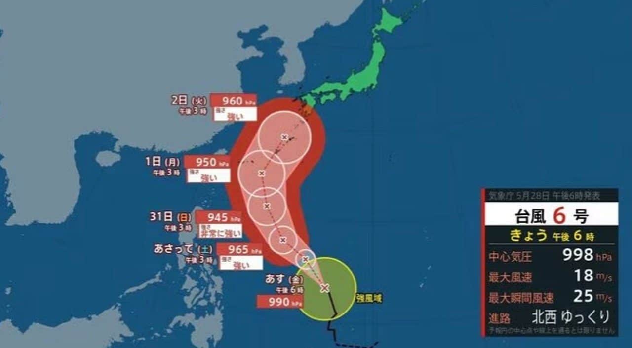
Tufão Chan-mi, classified as the sixth tropical system of the current season, advances across the ocean with a forecast of reaching the regions of Okinawa and Amami, in Japão, between the 1st and 2nd of June. Japão’s Agência Meteorológica has issued warnings about the rapid intensification of the phenomenon in the coming hours. The low pressure center should register 945 hectopascals. Rajadas wind speed can reach 60 meters per second during direct impact. Local authorities have initiated continuous monitoring protocols to mitigate structural damage in coastal areas.
The climate formation is currently east of Filipinas. The movement occurs slowly towards the northwest. Essa reduced speed over hot water favors system energy gains. The water temperature in the region remains above the historical average. Esse ocean heat serves as the primary fuel for the storm. The evaporation process transfers constant moisture to the upper layers of the atmosphere. Especialistas point out that the trajectory will deviate to the north-northwest before reaching Japanese territory. The change of route defines exactly which islands will receive the greatest volume of precipitation.
Evolução of the tropical system and route projection for the archipelago
The dynamics of typhoons in Oceano Pacífico require constant attention due to the unpredictability of air currents at altitude. Chan-mi demonstrates a strengthening pattern that mobilizes meteorologists. The peak intensity is scheduled for May 31st. Após that date, the system will maintain its strength as it crosses the open ocean toward the south of Japão. Pequenas variations in sea surface temperature directly affect the carrying capacity of winds. Satellite tracking shows a rapid organization of cloud bands around the eye of the storm.
The islands of Okinawa and Amami have a history of experiencing severe weather events. The approach of a system classified as very strong demands exceptional preparations. Local infrastructure, although designed to withstand windstorms, faces a significant test when gusts exceed the 50 meter per second mark. The provincial government directs city halls to review emergency shelters. Evacuation logistics need to be ready before the first bands of rain reach the continent.
Impactos of 945 hectopascals atmospheric pressure in infrastructure
The deepening of the central pressure to 945 hectopascals represents a clear indication of the severity of the meteorological event. Valores so low creates an extreme pressure gradient with respect to the surrounding air. Isso results in winds that extend over a wide radius from the center. The 60 meters per second mark is equivalent to more than 210 kilometers per hour. Large Veículos can be tipped over on highways. The aerodynamic force exerted on buildings increases quadratically in relation to the wind speed. Janelas glass without adequate protection can shatter, changing the internal pressure of the property.
The electricity sector mobilizes teams on standby to deal with the likely fall of poles and the rupture of high voltage cables. The interruption in power supply affects essential services such as hospitals, water treatment plants and telecommunications. Utilities recommend that people charge batteries and mobile devices in advance. Recovering the power grid takes days in rural areas that are difficult to access. Urban planning in Japanese cities helps reduce damage, but the force of nature imposes physical limits on building materials.
Official Monitoramento and updated storm data
The bulletins issued by Agência Meteorológica from Japão are based on complex mathematical models and data collected in real time. The measurement taken at 3pm on the 28th indicated a pressure of 998 hectopascals. The system was still in the initial organization phase. The continuous wind speed near the center read 18 meters per second. The instantaneous gusts reached 25 meters per second. The contrast between these initial numbers and the projection of 945 hectopascals illustrates the rate of intensification predicted for the coming days.
The latest technical report details the coordinates and physical characteristics of the tropical cyclone before its arrival in the Japanese archipelago. The information serves as a basis for decision-making by civil defense agencies and for logistical planning by city halls.
- Posição geographically concentrated east of Filipinas territory.
- Initial atmospheric Pressão measured at 998 hectopascals in the center.
- Ventos sustained at the 18 meters per second mark.
- Rajadas instantaneous maximums reaching 25 meters per second.
- Deslocamento at reduced speed heading northwest.
The use of state-of-the-art meteorological radars makes it possible to track the amount of precipitable water within clouds. Continuous monitoring identifies the exact moment the typhoon’s eye clearly forms. Essa visual clarity in satellite imagery confirms increased wind strength. Meteorologists cross-reference this information with ocean buoys spread across Pacífico. The result is a very short-term forecast that is highly reliable for government authorities.
Riscos coastal and safety protocols for local residents
The interaction of strong wind with the ocean surface generates large-amplitude waves that threaten the entire coastal strip. The rough seas make commercial navigation and artisanal fishing unfeasible in the Amami region. Port captaincies have issued orders for all vessels to return to safe berths. The risk of sinking increases exponentially as the system approaches. The rise in sea level, driven by low pressure, causes the phenomenon of storm tides.
Coastal flooding poses a direct danger to homes built near the beach. Salt water invades streets, affects crops and compromises freshwater reservoirs. The expected volume of rain also overloads urban drainage systems. Bairros located in topographic depressions face rapid flooding. Containment barriers installed along the coast help dissipate wave energy, but can be overcome by abnormal tide rise. Water-saturated soil loses cohesion, increasing the risk of landslides in mountainous areas.
Civil defense advises residents to prepare survival kits containing drinking water, non-perishable food, flashlights and a battery-operated radio. Review of escape routes to shelters located on high ground should be done before the weather worsens. Schools and public buildings serve as reception points for families living in risk areas. Official communication occurs through loudspeakers installed in the streets and text messages sent directly to cell phones. Coordination between the fire department and self-defense forces ensures the execution of civil protection protocols.