Typhoon No. 6 (Chan-mi) reaches 945 hectopascals and approaches Okinawa with winds of 60 m/s

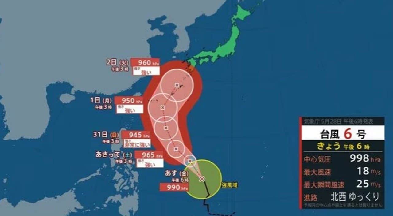
Tufão nº 6, named Chan-mi, is expected to intensify considerably over the next few hours, transforming into a very strong system with 945 hectopascals of central pressure. Agência Meteorológica’s Japão forecast indicates that the phenomenon will approach Okinawa and Amami around June 1st or 2nd. Especialistas warn of the possibility of wind gusts of up to 60 meters per second. Estas regions may experience rough seas and severe weather conditions, posing a risk of torrential rain and high tides.
Intensificação of Tufão Chan-mi and initial trajectory
Typhoon Chan-mi, currently classified as the sixth tropical system of the year, is in a process of significant intensification. Sua initial movement occurs east of Filipinas, where it moves slowly. Agência Meteorológica of Japão monitors the evolution of the phenomenon and projects that it will continue to strengthen. The predicted trajectory is to the northwest, followed by a shift to the north-northwest.
Esta movement is crucial as it directs the typhoon towards the regions of Okinawa and Amami. The estimate is that maximum intensification will occur until May 31st, with the approach of the Japanese islands around June 1st or 2nd. The local population follows the bulletins closely, aware of the destructive potential of such a robust system. The increased intensity poses a considerable challenge to the infrastructure and security of the area.
Meteorological authorities emphasize the dynamic nature of typhoons. Pequenas changes in trajectory can generate large differences in impacts. Therefore, Agência Meteorológica of Japão maintains constant updates, warning of the need for continuous vigilance. The prediction of becoming a “very strong” typhoon is an indication of the severity of the expected weather situation.
Previsão of extreme winds and low pressure in Okinawa
The intensification of Tufão Chan-mi will culminate in a central pressure of 945 hectopascals, a value that characterizes systems of great strength and destructive potential. Such low pressure at the center of the typhoon suggests a vast area of intense winds around it. Este weather data is crucial for assessing the threat. The specific forecast points to wind gusts that can reach 60 meters per second.
Tais wind speeds pose an extreme danger to buildings, infrastructure and transport. The force of these gusts can cause severe structural damage and down trees and power poles. Agência Meteorológica of Japão highlighted that these conditions are expected as the typhoon approaches and interacts with the region of Okinawa. Wind speeds are one of the most critical indicators for disaster preparedness.
Além of winds, low atmospheric pressure can have additional effects, such as rising sea levels. The combination of extreme winds and low atmospheric pressure contributes to adverse conditions. The potential for significant disruptions to everyday life is high, ranging from energy supply to mobility. The community is being informed about these risks so that they can take the necessary precautions.
Riscos imminent for the coastal regions of Amami
The Okinawa and Amami regions are preparing to face rough seas and severe weather conditions. The approach of Tufão Chan-mi brings with it the risk of high waves, which could reach dangerous proportions for navigation and coastal activities. Sea instability is a primary concern, especially for fishermen and smaller vessels. The population should avoid maritime activities during the period of greatest intensity of the typhoon.
Outro significant risk is that of torrential rains. The expected rainfall volume could overwhelm drainage systems, resulting in flash flooding in low-lying and urban areas. In regions with more rugged topography, there is an increased danger of landslides, which adds an extra layer of complexity to prevention efforts. The amount of rain is a determining factor in the severity of floods.
High tides are also a point of attention, with the possibility of reaching alert levels. Este phenomenon, known as coastal storm surge or storm surge, is heightened by the typhoon’s low pressure and winds that push water toward the coast. Coastal flooding can directly impact homes and establishments close to the sea. The exact trajectory of the typhoon will be decisive in determining the extent and severity of these impacts on the coastline.
Typhoon Current Situação and Agência Meteorológica Monitoring
Agência Meteorológica of Japão has released the latest data on Tufão #6 (Chan-mi). Às 15:00 on the 28th, the center of the typhoon was located east of Filipinas, making a slow movement towards the northwest. Esta initial observation is essential to understand the evolution of the system. The typhoon’s central pressure at that time was measured at 998 hectopascals.
The maximum wind speed near the center of the system was recorded at 18 meters per second. Já maximum instantaneous wind speed reached 25 meters per second. Esses data represents the intensity of the typhoon at its current stage. These parameters are expected to increase significantly in the coming days. Continuous monitoring allows alerts to be issued and projections to be updated.
- Current Localização of the typhoon at 6pm on the 28th: Leste of Filipinas
- Pressão currently registered core: 998 hectopascals
- Velocidade maximum wind near center: 18 meters per second
- Velocidade maximum observed instantaneous wind: 25 meters per second
- System Movimento: Lentamente for northwest
Agência Meteorológica’s Japão uses advanced simulations to predict the typhoon’s future trajectory and intensity. Essas tools are essential for providing accurate and timely information to the population. The contrast between current data and future projections highlights the importance of preparation. The typhoon is expected to intensify considerably on its journey.
Medidas prevention and alerts for the local population
Diante of the severe conditions forecast, Agência Meteorológica of Japão reiterated the information on disaster prevention. The Okinawa and Amami regions are the most vulnerable areas. The forecast points to rough seas and unstable weather between June 1st and 2nd. Local people are advised to strictly follow the authorities’ guidelines.
The possibility of torrential rain and coastal storms is a major concern. Há a concrete risk that these events will reach alert levels. Isso means conditions may become dangerous, requiring immediate protective action. Preparation includes checking homes, securing assets, and identifying safe evacuation routes.
Authorities recommend that residents of Okinawa and Amami stay up to date with weather reports. It is essential to have a family emergency plan. Ter Basic supplies, such as drinking water, non-perishable food, and flashlights, are an essential preventative measure. Community cooperation is vital to mitigating the impacts of Tufão Chan-mi.