
Risk of flash flooding remains high in Texas with heavy rain and warning extended to the south of the state


A strong storm hit the southern United States and generated a flood warning in Texas this Monday (15). Significant volumes of rain in a short space of time caused historic flooding and left drivers stranded on the I-35 highway in the Waco region. The force of the water covered vehicles and mobilized security forces for emergency rescues.
Meteorological monitoring indicates that the accumulated rainfall varied between 7.5 and 12.5 centimeters in a few hours in the most affected areas. Cities like Waco and Austin saw immediate severe flooding. Faced with the dangerous scenario, authorities extended safety warnings throughout the central and southern region of Texas.
On the I-35 highway, one of the main roads in the Waco region, the flood turned the road into an artificial river and left dozens of drivers trapped inside their cars. Agents from the Texas Ranger Corps work in conjunction with local relief teams to remove residents from risk areas. Video records taken by drivers and local broadcasters show cars completely submerged by the advancing flood.
Reports from those who experienced the storm indicate that the water level rose very quickly. Reports from the field show residents wading through waist-deep water to escape flooded areas before the first rescue teams arrived. The local civil protection system reported that containment barriers prevented even greater destruction on roads adjacent to the highway.
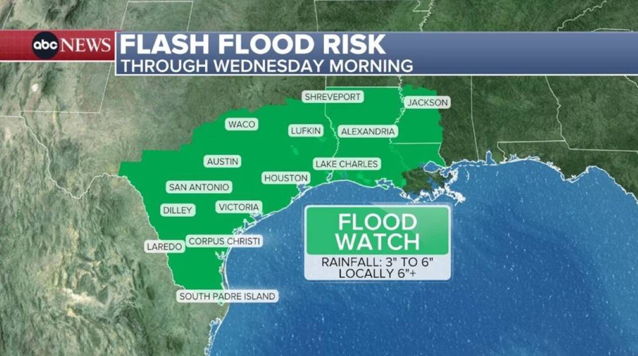
Stationary cold front prolongs flood risk
The climate instability is caused by a stationary cold front that has positioned itself over the south of the country. This weather pattern should slow airflow and maintain the possibility of daily thunderstorms throughout the week.
The perimeter at critical risk is not limited to Texas. The warning has been extended to most of Louisiana and southwestern Mississippi, with an initial effect until Wednesday morning. Forecasters predict isolated torrential rain showers that could reach rates of 5 to 10 centimeters per hour.
The Houston metropolitan region turned on the maximum alert signal with a moderate risk rating (level 3 out of 4) for excessive precipitation. The danger of urban flooding is expected to persist for four consecutive days in the city. Houston’s vulnerability is magnified by its flat geographic feature and proximity to the waters of the Gulf of Mexico, factors that make it difficult for water to flow quickly.
To make matters worse at the end of the week, a low pressure system moving through the Gulf of Mexico could inject even more moisture over southern Texas. This phenomenon has the potential to increase storms and extend the period of severe flooding until next weekend.
Climatic contrast brings record heat to the Northwest
While the southern portion of the United States suffers from excess rainfall, states in the far west face the opposite climate reality. The Pacific Northwest recorded historic temperature marks last Sunday, with thermometers reaching atypical levels for the region in Seattle and Portland.
Maximum temperature indicators are expected to rise even further this Monday, with marks close to 100°F in Portland and around 90°F in Seattle. Local health departments have issued warnings to the population due to heat stress, as well as warnings about the risk of wildfires spreading through dry vegetation.
The tendency is for the extreme heat to begin to lose strength from Tuesday onwards. A milder air mass should drop highs to the 21°C range in Seattle and 27°C in Portland throughout the week.
Midwest goes on alert for tornadoes and hail
The central swath of the country is also under close surveillance by the national meteorological service. A level 3 alert on a scale going up to 5 has been issued for next Wednesday, covering an area ranging from Missouri to the states of Illinois and Indiana.
The forecast for these locations indicates a high probability of severe violent phenomena, such as:
- Winds with destructive potential above 100 km/h
- Hailstorm with large rocks
- Formation of strong tornadoes
Densely populated cities such as Indianapolis, St. Louis, Springfield, Peoria and Columbia are in the direct path of the severe storm. Neighboring areas, including the urban centers of Chicago, Columbus, Kansas City, Wichita and Toledo, operate at alert level 2 out of 5 and must follow security recommendations from local civil defenses.





