
Invest 92L threatens southern coast with heavy rain as storm formation odds reach 80 percent

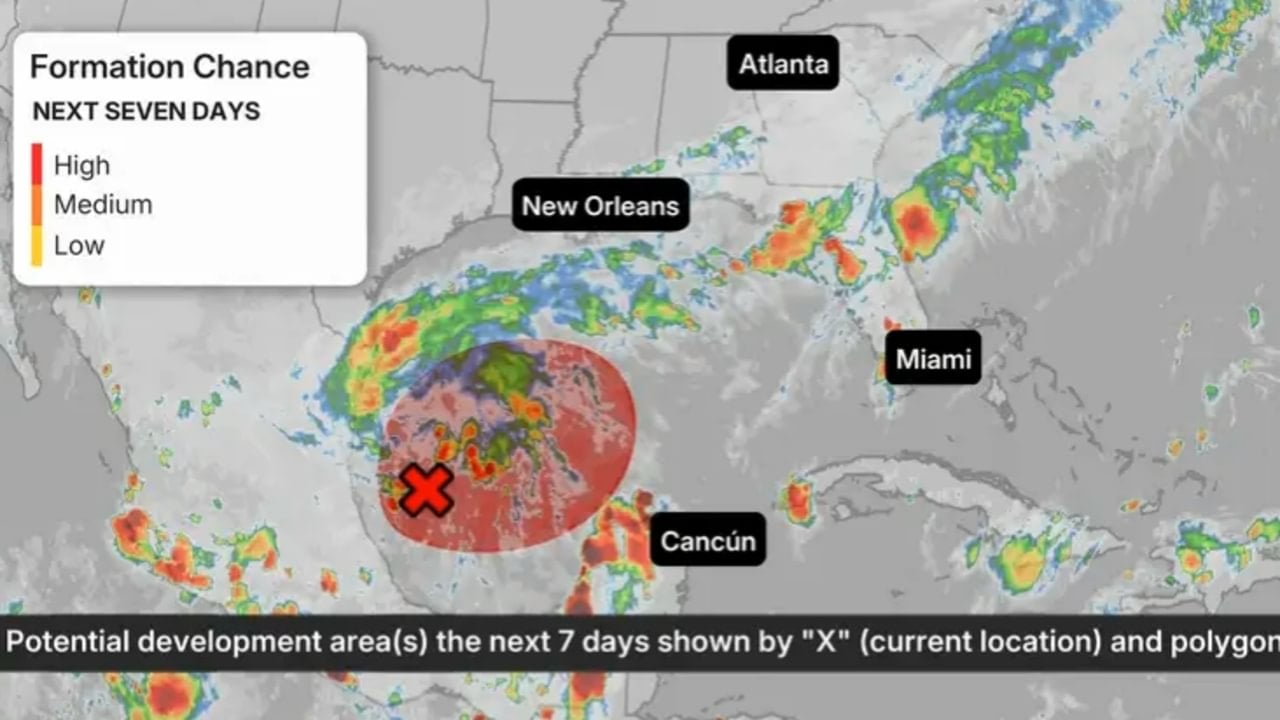
Atmospheric disturbance Invest 92L is gathering strength in the southwestern Gulf of Mexico, prompting federal meteorologists to track its path as conditions ripen for tropical cyclone formation. The National Hurricane Center assigned the low-pressure system an 80 percent probability of developing into a tropical cyclone within the next seven days, placing coastal communities across the southern United States on alert for potential weekend landfall. Government forecasters continue to analyze satellite observations and atmospheric soundings to determine the exact trajectory of the system across warm waters.
Computer guidance indicates that the broad area of low pressure situated off the coast of Mexico could organize into a tropical depression by Wednesday, October 7, 2026. Should its sustained winds reach the 39 mph threshold, the system will officially be designated as Tropical Storm Isaias, marking the ninth named storm of the 2026 Atlantic hurricane season. To determine the precise wind circulation and central atmospheric pressure, the meteorological agency scheduled an airborne reconnaissance mission with hurricane hunter crews for Wednesday afternoon.
Projected trajectory across open waters toward the northern Gulf coastline
Initial track estimates suggest that the disturbance will drift eastward across the Bay of Campeche before executing a definitive northward turn into the wider Gulf basin. Mathematical models outline a broad potential impact zone stretching from southeastern Louisiana across the coastal counties of the Florida Panhandle. Forecasters including Houston Chronicle meteorologist Justin Ballard and WKMG News 6 chief meteorologist Candace Campos are tracking model fluctuations, noting that steering currents have not yet locked down the exact landfall location or the final intensity of the system.
Inbound moisture from the disturbance poses a severe risk of high precipitation totals for interior locations that already suffer from saturated ground due to previous rainfall events. Higher terrain and mountainous pockets across the American Southeast remain under heightened scrutiny for potential soil slippage and mudslides, while low-lying river plains and coastal communities monitor threats of rapid flash flooding. Drainage basins throughout the region are operating near capacity, limiting the landscape’s ability to absorb sudden downpours.
Regional utility operators and critical infrastructure providers throughout the coastal corridor have enacted preliminary readiness measures to mitigate power outages and disruptions to municipal water supplies. Lena Dziechowski, chief meteorologist at CenterPoint Energy, explained the utility’s logistical mobilization in a company advisory. “Our teams have been actively monitoring the development potential in this region since last week. We are taking steps to support our customers, including continuing to monitor conditions and reviewing our readiness plans. We encourage all customers across the Greater Houston area to stay weather-aware as the forecast evolves,” she stated.
Read also: Atlantic Ocean records zero hurricanes past September 10
Atmospheric upper-level winds create barrier to rapid system strengthening
Strong upper-level winds associated with the jet stream across the northern Gulf of Mexico, scientifically recognized as vertical wind shear, are projected to impede the storm’s ability to organize into a intense vortex. This structural shearing mechanism frequently disrupts the symmetrical alignment of deep thunderstorm clouds, causing tropical cyclones to lose core wind organization before reaching mainland beaches. Even so, weather specialists caution that a minor northward retreat of the prevailing jet stream could create an environmental window for transient intensification over warm waters.
Even if intense wind shear keeps maximum sustained winds below hurricane strength along the beachfront, heavy tropical rainfall remains the primary hazard facing coastal populations. Operational meteorologists stress that slower-moving tropical systems frequently inflict catastrophic monetary damage through prolonged freshwater flooding rather than direct mechanical wind destruction. Urban centers with complex stormwater infrastructure face distinct flash flood dangers during periods of concentrated precipitation bands.
Strong climatic pattern suppresses broader Atlantic basin hurricane formation
Overall tropical activity across the Atlantic basin throughout 2026 remains remarkably subdued because of a robust El Niño climate pattern situated in the equatorial Pacific Ocean. This oceanic configuration disrupts global atmospheric dynamics by injecting persistent westerly winds aloft across the Caribbean Sea and the Atlantic, suppressing tropical wave maturation. Through October 5, 2026, the entire Atlantic basin recorded zero hurricanes, establishing the first hurricane-free month of September documented in 32 years. The name Isaias stands on the rotating naming list managed by the World Meteorological Organization, having replaced Hurricane Ike following that system’s catastrophic strike against the Texas coastline in 2008.
Despite these hostile broader background conditions, three distinct tropical storms managed to overcome localized shear zones and make landfall along Gulf Coast shores during the 2026 calendar year:
Keep reading: Polar vortex changes and super El Niño cloud US winter forecasts
- June 2026: Tropical Storm Arthur made landfall in Texas and dropped a localized deluge of 37.53 inches of rain on Alexandria, Louisiana, establishing a historic rainfall benchmark for a tropical system in that sector.
- July 22, 2026: Tropical Storm Bertha moved onshore across the Biloxi Wildlife Management Area within St. Bernard Parish, Louisiana, carrying sustained surface winds of 45 mph.
- September 1, 2026: Tropical Storm Edouard made landfall along the Gulf perimeter with continuous winds reaching 60 mph alongside heavy coastal downpours.
Anticipated operational schedule for Invest 92L tracking and hazards
Meteorological agencies established a systematic timeline detailing the anticipated evolution of the disturbance as it transfers tropical moisture into the southern United States:
- Monday, October 5, 2026: The National Hurricane Center released an update at 2:00 PM EDT raising development odds to 60 percent within 48 hours and 80 percent over seven days.
- Wednesday, October 7, 2026: Airborne reconnaissance aircraft embark on an afternoon mission to directly assess central barometric pressure and identify whether a closed circulation center has solidified.
- Friday, October 9, 2026: The threat of intense downpours and squall-line wind gusts expands significantly across the territory between Louisiana and the Florida Panhandle.
- Sunday, October 11, 2026: Lingering tropical moisture continues to sustain an elevated risk of flash flooding and swollen drainage basins across coastal municipalities and inland communities in the American Southeast.
Emergency management personnel advise residents residing anywhere along the coastline from Texas eastward to Florida to review their household safety supplies and follow real-time forecast updates. Local civil defense agencies will issue localized watches and warnings if closed low-level circulation confirms the establishment of a named tropical system.





