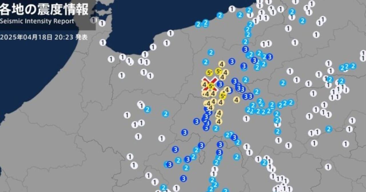
A powerful earthquake with a magnitude of 5.0 struck northern and central Nagano Prefecture, Japan, at 8:19 p.m. on April 18, 2025, local time. The quake, occurring at a depth of approximately 10 kilometers, had its epicenter in the northern part of the prefecture, according to the Japan Meteorological Agency. The maximum seismic intensity, rated as 5-lower on the Japanese scale, was felt in the city of Omachi, the village of Ogawa, and the village of Chikuhoku. Despite the intensity of the tremor, no significant structural damage or casualties have been reported, and authorities confirmed there is no risk of a tsunami.
The Japan Meteorological Agency issued an emergency earthquake alert immediately after the event, a precautionary measure for areas experiencing an intensity of 5-lower or higher. Japan’s advanced early warning system, known for its reliability, notified residents seconds before the quake’s impact. In Omachi, Ogawa, and Chikuhoku, the tremor was strong enough to knock small objects off shelves and startle residents, but local infrastructure withstood the shaking. Other areas, such as the cities of Nagano, Matsumoto, and Azumino, experienced a seismic intensity of 4, while more distant regions, including parts of Niigata, Ishikawa, and Aichi, felt tremors ranging from intensity 1 to 3.
The quake’s immediate impact was felt in transportation. JR Central, the operator of the Shinano express trains, reported delays on several lines crossing Nagano Prefecture. Trains were temporarily halted for safety inspections of the tracks, a standard procedure following seismic events. Passengers at stations like Nagano and Matsumoto faced delays of up to 30 minutes, but services gradually resumed. The swift response from authorities and transportation companies underscores Japan’s preparedness for seismic events, built on decades of investment in infrastructure and technology.
Seismic intensity across regions
The earthquake resulted in varying levels of intensity across different areas, as reported by the Japan Meteorological Agency. Below is a detailed breakdown of the recorded intensities:
- Intensity 5-lower: City of Omachi, village of Ogawa, village of Chikuhoku (Nagano).
- Intensity 4: Cities of Nagano, Ikeda, Matsukawa, Matsumoto, Azumino, and villages of Aoki, Omi, Ikuzaka (Nagano).
- Intensity 3: Cities of Chikuma, Sakaki, Yamanouchi, Shinano, Ueda, Suwa, Shiojiri, and villages of Yamagata, Asahi, among others (Nagano).
- Intensity 2 and 1: More distant regions, including cities in Niigata (Itoigawa, Myoko), Ishikawa (Noto, Nanao), Aichi (Toyohashi, Nagoya), and even Kanagawa (Chigasaki) and Toyama (Uozu).
Japan’s seismic context
Japan is one of the most earthquake-prone countries in the world, situated on the Pacific Ring of Fire, a region of intense tectonic activity. The collision of tectonic plates, such as the Pacific Plate and the Eurasian Plate, triggers approximately 400 tremors daily across the archipelago, though most are imperceptible. The Nagano earthquake, while moderate, renews discussions about preparedness for larger-magnitude events, particularly in central Japan, where active fault lines are closely monitored.
Nagano Prefecture, nestled in the rugged terrain of the Japanese Alps, is known for its significant geological faults. The region has experienced notable quakes in the past, such as the 2014 magnitude 6.7 earthquake that caused landslides and damage in villages like Hakuba. The April 18 event, though less severe, underscores the need for ongoing vigilance. The shallow depth of the epicenter, at just 10 kilometers, amplified the tremor’s perception in nearby areas but also limited its potential for widespread damage.
The Japan Meteorological Agency operates a network of 180 seismographs and 627 seismic intensity meters, providing real-time data to authorities and media. This system enables rapid responses, such as issuing emergency alerts and suspending transportation services. Additionally, Japan invests heavily in seismic-resistant construction, with buildings designed to absorb vibrations, and in regular public training. In Nagano, local communities participate in evacuation drills, contributing to resilience during crises.
Immediate impacts and authorities’ response
The city of Omachi, one of the hardest-hit areas, is a tourist hub known for its mountains and lakes. The quake briefly disrupted commercial activities, with shops and restaurants closing temporarily for inspections. Schools and public buildings underwent safety checks, but no collapses or significant cracks were reported. In the rural villages of Ogawa and Chikuhoku, with smaller populations, residents reported being startled, but calm was quickly restored.
Local authorities activated emergency protocols, including inspections of dams and reservoirs, which are vulnerable to seismic activity. The Azumi hydroelectric plant, near the epicenter, was evaluated and showed no abnormalities. The Japan Meteorological Agency warned of potential aftershocks in the coming hours, advising residents to avoid areas near slopes, where landslides pose a risk during seismic events.
The temporary suspension of Shinano express trains caused inconvenience for tourists and commuters reliant on rail transport. JR Central reported that inspections found no damage to the tracks, and services resumed within two hours. The efficiency of the response reflects Japan’s robust disaster preparedness, with transportation systems designed to handle disruptions from natural disasters. At train stations, screens displayed seismic alerts, and staff guided passengers to take cover during the quake.
Recent seismic history in Nagano
Nagano has a history of significant seismic activity, keeping the region on constant alert. Below is a timeline of notable seismic events in the prefecture:
- 1984: Magnitude 6.8 earthquake in western Nagano, causing landslides in Otari.
- 2011: Magnitude 6.7 quake in Nagano, linked to aftershocks of the Great Tohoku Earthquake.
- 2014: Magnitude 6.7 earthquake in Hakuba, damaging homes and causing injuries.
- 2020: Seismic swarm in Nagano and Gifu, with over 170 tremors recorded over two months.
- 2025 (April 18): Magnitude 5.0 earthquake in northern and central Nagano, with no major damage.
Japan’s earthquake preparedness
Japan’s approach to earthquake preparedness is a global benchmark. Since the devastating 1923 Kanto Earthquake, which killed over 140,000 people, the country has implemented stringent measures to mitigate risks. Buildings constructed after 1981 adhere to seismic codes that include base isolation systems, with rubber bearings and dampers to absorb vibrations. In Nagano, where many structures are older, retrofitting programs are encouraged by local governments.
The public plays an active role in preparedness. Schools conduct monthly evacuation drills, and households are equipped with emergency kits containing water, food, and flashlights. In Omachi, the local government runs a community training program that teaches residents to secure furniture and identify evacuation routes. These efforts have significantly reduced the impact of moderate quakes, such as the April 18 event.
Technology is a cornerstone of Japan’s strategy. The Japan Meteorological Agency’s early warning system detects primary seismic waves (P-waves) and issues alerts before the arrival of more destructive secondary waves (S-waves). This brief window allows trains to stop, factories to halt operations, and people to seek cover. In the Nagano quake, the alert was successfully issued, though the 5-lower intensity did not require large-scale evacuations.
Geological risks in Nagano
Nagano Prefecture lies near several active fault lines, including the Itoigawa-Shizuoka Tectonic Line Fault Zone, one of Japan’s most closely monitored faults. This fault, stretching across central Japan, is capable of producing earthquakes exceeding magnitude 7. The proximity of the April 18 epicenter to Mount Yakedake, a dormant volcano, raised concerns, though no signs of volcanic activity were detected.
Landslides are a significant risk in Nagano, particularly in mountainous areas like Omachi and Chikuhoku. Following the quake, prefectural teams inspected slopes and rural roads, where recent rainfall may have weakened the soil. The Japan Meteorological Agency advised residents to avoid high-risk areas until conditions were assessed. Dams, such as the Azumi dam, were also monitored to ensure the safety of downstream communities.
The shallow epicenter depth of 10 kilometers explains the strong local perception of the quake. Shallow earthquakes tend to produce intense shaking in nearby areas but dissipate energy quickly, limiting broader damage. In contrast, deeper quakes, like the 2011 Fukushima event, can affect larger regions but with reduced local intensity.
Impacts in neighboring regions
While the epicenter was in Nagano, the quake was felt in neighboring prefectures, including Niigata, Ishikawa, Gifu, Aichi, and even distant areas like Kanagawa and Toyama. In Niigata, the city of Itoigawa recorded intensity 2, while in Aichi, parts of Nagoya experienced mild shaking at intensity 1. These regions, though less affected, activated monitoring protocols to assess potential aftershocks.
In Toyama, the city of Uozu reported minor tremors but no significant disruptions. In Kanagawa, Chigasaki, over 200 kilometers from the epicenter, recorded intensity 1, highlighting the sensitivity of Japan’s seismic network. The lack of damage in these areas reflects the resilience of regional infrastructure, designed to withstand moderate quakes.
The quake’s reach to distant areas underscores Japan’s geological interconnectedness. The Pacific Plate, subducting beneath the Eurasian Plate, creates a fault network that can transmit vibrations over long distances. This phenomenon is common in shallow quakes like Nagano’s and reinforces the need for integrated alert systems nationwide.
Recommended safety measures
The Japan Meteorological Agency issued guidance for residents of Nagano and nearby areas following the earthquake. Below are key recommendations:
- Avoid high-risk areas: Stay away from slopes or damaged buildings until cleared by authorities.
- Prepare emergency kits: Keep water, food, and flashlights for at least three days.
- Secure furniture: Ensure shelves and heavy objects are fixed to prevent falling during aftershocks.
- Participate in drills: Engage in community-led evacuation training programs.
Outlook for the coming days
Nagano authorities remain on alert for potential aftershocks, which are common following magnitude 5.0 quakes. While most aftershocks are low-intensity, they can cause minor damage to weakened structures. The Japan Meteorological Agency stated that monitoring will be intensified over the next 48 hours, with regular updates provided to the public.
JR Central confirmed that Shinano express trains have resumed normal operations since the early hours of April 19, though additional inspections will be conducted in mountainous sections. Schools in Omachi and nearby villages will operate as usual, but students have been advised to avoid outdoor areas during breaks. The Nagano prefectural government plans to review evacuation plans in rural areas, where access to shelters may be limited.
The April 18 earthquake, while causing no major damage, serves as a reminder of Japan’s seismic vulnerability. The rapid response from authorities and the preparedness of the population minimized impacts, but the potential for more significant events keeps the region on high alert. Japan’s combination of advanced technology, resilient infrastructure, and community engagement remains the foundation of its disaster response strategy.