Artemis 2 mission maps the far side of the Moon and expands data on mineral resources in space
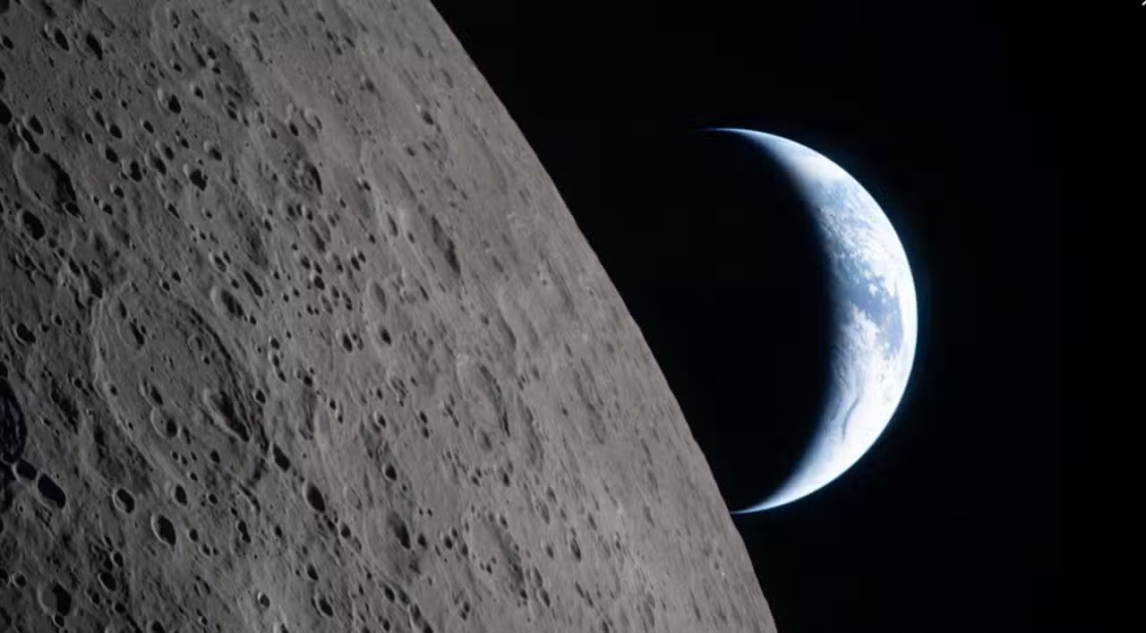
The space mission crew achieved a historic milestone in scientific exploration by flying over the invisible face of the natural satellite Terra on Monday, April 6, 2026, collecting visual and topographic data from a region unexplored by humans for more than five decades. Spacecraft Orion, commanded by Reid Wiseman and made up of astronauts Victor Glover, Christina Koch and Jeremy Hansen, reached a distance of 406,771 kilometers from our planet during the orbital maneuver. Esse distance surpassed the record set by mission Apollo 13 in 1970, consolidating the return of manned operations to the deep space environment. The flight allowed direct observation of complex geological formations, marking a new stage in the international program that aims to establish a sustainable human presence outside low Earth orbit.
During the journey on the invisible side, the team operated completely autonomously for approximately 40 minutes. Esse period of communications silence occurs due to the physical blocking of radio signals by the lunar mass itself, requiring independent navigation systems and precision in trajectory calculations.
Experience the magic of our Moon mission wherever you go! ✨
Download free, mobile wallpapers and bring your device into the new era of exploration:https://t.co/494ZyUBtve pic.twitter.com/9kRxnhoZu6
— NASA (@NASA)April 8, 2026
Key observations documented by the crew during this critical phase of the flight included:
– Visual mapping of basin Mare Orientale, an impact structure approximately 930 kilometers long.
– The identification of a significantly thicker and older crust compared to the face facing Terra.
– The collection of high-resolution images that complement topographic surveys previously carried out by robotic probes.
Geological formations and records of Sistema Solar
The surface of the hidden face presents morphological characteristics that are profoundly different from those observed on the visible side from Terra. The absence of vast basaltic plains, known as lunar seas, reveals a rugged terrain densely marked by impact craters of different proportions and ages.
Scientists point out that this geological asymmetry is linked to the cooling process of the celestial body shortly after its formation. The side facing Terra remained heated for a longer period due to thermal radiation emitted by our planet, while the opposite side cooled rapidly, developing a thick, rigid crust.
This structural configuration transformed the region into a true preserved geological archive, capable of providing precise information about the period of Bombardeio Intenso Tardio. The photographs and videos captured by the astronauts offer a new perspective on the dynamics of crater formation around 4 billion years ago.
Autonomous operations and communication blocking
Synchronized rotation creates a natural obstacle to controlling space missions, as it prevents direct transmission of radio waves between the spacecraft and ground-based command centers. Para To circumvent this limitation, space agencies rely on auxiliary satellites positioned in specific orbits to act as data relays.


The crew’s success in navigating and performing scientific experiments during signal jamming validates safety protocols developed for long-duration missions. The ability to make real-time decisions without support from ground control is a key requirement for future expeditions to Marte.
Economic potential and exploration of mineral resources
The detailed mapping of the topography reinforces international interest in prospecting for natural resources deposited in the satellite’s subsoil. Pesquisas indicate the presence of rare earth elements and strategic minerals that have high added value for the advanced technology industry in Terra.
One of the compounds most targeted by space agencies is the isotope helium-3, which accumulates in the surface layers of regolith due to constant exposure to solar winds. Esse element is considered a promising fuel for nuclear fusion reactors, offering a clean and highly efficient energy alternative.
In addition to minerals, the identification of areas with lower incidence of sunlight raises questions about the distribution of frozen water in polar craters and in regions of permanent shadow. Ice extraction is vital for producing oxygen and rocket fuel directly in space.
The information collected visually by the Orion team will be cross-referenced with data obtained by recent unmanned missions. The objective is to create a map of viable resources that will guide the choice of landing sites for the next stages of the space program.
Contributions from international robotic missions
Before the manned flyby, knowledge about the unseen face depended almost exclusively on probes and rovers sent by Asian space programs. Expedições as well as Chang’e 4, carried out in 2019, and Chang’e 6, which returned with soil samples in 2024, provided the first direct chemical analyzes of the regolith from this specific region. The materials brought to Terra revealed a distinct mineralogical composition, with significant variations in the concentration of iron and titanium oxides, in addition to confirming the extreme temperatures that can reach minus 100 degrees Celsius during the lunar night.
Integrating the chemical data obtained by these probes with the topographic observations now made by human eyes creates a more accurate three-dimensional model of the surface environment. Essa indirect cooperation of scientific information allows researchers to better understand how meteorite impacts over billions of years have distributed volatile materials throughout the crust. Cross-referencing these discoveries is essential for designing habitats and mining equipment that will need to withstand the harsh conditions of the isolated terrain.
Installation of advanced scientific infrastructure
The environment of absolute radio silence found on the far side offers unparalleled conditions for observational astronomy, motivating projects to build large radio telescopes on the surface. Longe of the interference generated by radio, television and commercial satellite transmissions from Terra, the equipment installed in this region could capture low-frequency signals from the beginnings of the universe, shortly after Big Bang. as raw material. The passage of Orion helped identify plains and depressions with enough geological stability to house complex foundations, uniting manned exploration with the interests of cutting-edge astrophysics in the search for answers about the formation of the first galaxies.
Preparation for landing at the lunar south pole
The maneuvers carried out during the maximum distance from Terra serve as a rigorous test for mission Artemis 3, whose main objective is to land astronauts in the South Pole region. Validation of life support and optical navigation systems ensures that current technology is capable of sustaining surface operations in areas of extreme topography.
New phase of human presence in space
The safe return of the capsule and the successful transmission of data packets mark the transition from the testing phase to the execution of long-stay missions. The space program is now moving towards the construction of orbital stations that will serve as a logistical support point.
Direct observation of the far side reiterates the importance of the human presence in scientific exploration, combining the intuition and adaptability of astronauts with the precision of robotic instruments. Esse Hybrid exploration model sets the operational standard for future interplanetary travel.
Veja Tambem em Latest News (EN)

Atlético-MG confirms agreement with defender Léo Duarte after period of prominence in Turkish football

Tiger shark bites 19-year-old girl and rips off her leg in Boa Viagem, Recife

2026 World Cup will have 32 athletes who play in Brazilian football

OnePlus develops portable video game with Android system focused on competitive shooters

New BYD Seal 6 DM-i Touring hybrid station wagon debuts in Europe with ample interior space and super-efficient engine

Costco reaches historic volume in gasoline sales in the United States with prices below market

June PlayStation Plus Catalog Brings Grounded and Warhammer 40,000 Darktide to Subscribers
Disney+ brings Avatar Fire and Ash finale to The Bear and new Pixar animation in June
Netflix updates June catalog with new season of Avatar and classic cinema sagas

Geely Xingyuan electric compact gains 47 kWh battery and autonomous driving system in China

Episode 1156 of One Piece marks arrival at Elbaf with decisive actions by Shanks and Blackbeard