

An intense 6.0 magnitude earthquake struck Yamanashi Prefecture, Japan, at around 10:28 pm on June 26, 2026. Authorities confirmed that the event does not pose any tsunami threat to the coastal region.
Details of the phenomenon and historical impact on the region
The Japan Meteorological Agency reported that no significant changes were identified in monitoring data from Mount Fuji following the recent tremor.
The event marks the first time since 1924 that an earthquake of magnitude 6 or greater has been recorded in Yamanashi Prefecture, highlighting the rarity and intensity of the tremor.
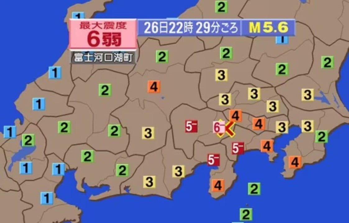
In terms of seismic intensity, the city of Fujikawaguchiko in Yamanashi registered 6- on the Japanese scale, while the city of Otsuki observed a tremor of 5+.
Additionally, tremors with a seismic intensity of 5- were detected in several locations, including the neighborhood of Midori, in the city of Sagamihara, and in the cities of Matsuda, Nakai and Yamakita, in Kanagawa Prefecture. In Yamanashi Prefecture, the cities of Kofu, Fujiyoshida, Fuefuki, Koshu, Fujikawa and Nishikatsura were affected, in addition to the villages of Oshino, Yamanakako and Narusawa. The city of Oyama, in Shizuoka Prefecture, also felt this level of shaking.
Intensity 4 tremors were felt over a wide area, covering Minamiboso, Chiba Prefecture; several cities in Tokyo, such as Hachioji and Ome; Yokohama, Kawasaki, Sagamihara and others in Kanagawa; Tsuru, Yamanashi and Minami-Alps in Yamanashi Prefecture; Kawakami, in Nagano; and several cities in Shizuoka, such as Numazu and Mishima.
In an even wider area, which includes the regions of Tohoku, Kanto-Koshinetsu, Tokai, Hokuriku, Kinki and Chugoku, tremors with intensities ranging from 3 to 1 were observed.
According to observations by the Japan Meteorological Agency, the epicenter of the earthquake was located in the eastern portion of Yamanashi Prefecture, close to the Fuji Five Lakes. The tremor occurred at a depth of 20 kilometers, and the magnitude was estimated at 5.6, after detailed analysis.
The time of the tremor was revised by the Japan Meteorological Agency, which adjusted the time of occurrence from approximately 10:29 pm to 10:28 pm on the 26th, based on an in-depth analysis of seismic data.
Detection of long-period seismic movements and their effects
Long-period “Class 1” seismic movements have been identified in Kanagawa, Yamanashi, and Shizuoka prefectures.
The earthquake with a seismic intensity of 6-, observed in Yamanashi Prefecture at around 10:29 pm on the 26th, was accompanied by a prolonged and slow tremor in Kanagawa, Yamanashi and Shizuoka Prefectures, characterized as a “Class 1” long-period ground movement.
The areas that recorded the lowest level of this type of tremor, “Level 1” (out of four categories), included the Tsurumi neighborhood in Yokohama, the cities of Hiratsuka and Hadano in Kanagawa, the cities of Koshu and Fujikawaguchiko in Yamanashi, and the city of Gotemba in Shizuoka.
Long-period ground motion is characterized by an intense and slow-paced vibration, lasting more than 2 seconds, typical of large-magnitude earthquakes and which mainly impacts high-rise buildings.
The Japan Meteorological Agency classifies a “Class 1” tremor as “moderately strong,” indicating that most people in tall buildings will feel the shaking, and overhead objects such as blinds will sway sharply.
Monitoring Mount Fuji after the earthquake
The Japan Meteorological Agency confirmed that no significant changes have been observed in Mount Fuji observation data since the recent earthquake occurred.
Safety guidelines for areas affected by intensity 6-
According to the Japan Meteorological Agency, an earthquake of intensity 6- makes it extremely difficult to stand upright, and much of the unsecured furniture inside a home can shift or tip over.
If there are pieces of crockery or glass lying around, there is a risk of injury when trying to clean them up. It is advisable to avoid unnecessary risks and use slippers or shoes when moving around the house.
In addition, some buildings may have suffered damage, such as falling or breaking tiles and glass. Wooden constructions with little seismic resistance are subject to large cracks in the walls or the detachment of tiles.
There is a possibility of buildings tilting or collapsing. The advice is to evacuate to a safe location if remaining inside a structure becomes uncertain.
In external areas, unreinforced concrete block walls may collapse, posing an additional risk.
Ground fissures are possible on unstable slopes and terrain, and there is a risk of landslides and mudslides. It is crucial to stay away from dangerous areas such as cliffs.
Historical precedents for earthquakes in and around Yamanashi
This is the first time Yamanashi Prefecture has recorded an earthquake of magnitude 6 or greater since the 7.3 magnitude quake that struck western Kanagawa Prefecture in January 1924.
In a previous event, on March 15, 2011, a magnitude 6.4 earthquake, with an epicenter in eastern Shizuoka Prefecture, reached a maximum seismic intensity of 6+ in Shizuoka and 5+ in Yamanashi Prefecture.
According to the government headquarters for the Promotion of Earthquake Research, tremors of magnitude 5 to 6 occur sporadically between 10 and 30 kilometers deep in the area stretching from eastern Yamanashi to the Tanzawa Mountains in northwestern Kanagawa. Such events are believed to result from the collision of the Izu Peninsula with the continental plate.
In 1983, a 6.0 magnitude earthquake caused damage in the city of Otsuki, in Yamanashi Prefecture, resulting in the collapse of concrete walls and the destruction of homes.
Most affected locations and recorded tremor levels
A seismic intensity of 6- was specifically observed in the city of Fujikawaguchiko, Yamanashi Prefecture.
Tremors with a seismic intensity greater than 5 were recorded in the city of Otsuki, Yamanashi Prefecture.
Areas that have experienced earthquakes with a seismic intensity of 5- include the Midori neighborhood in Sagamihara City, the cities of Nakai, Matsuda and Yamakita in Kanagawa Prefecture. In Yamanashi Prefecture, these were the cities of Kofu, Fujiyoshida, Fuefuki, Koshu, Fujikawa and Nishikatsura, and the villages of Oshino, Yamanakako and Narusawa. The city of Oyama, in Shizuoka Prefecture, was also affected.
An intensity 4 earthquake was felt in several locations, such as the city of Minamiboso, in Chiba Prefecture, and the cities of Hachioji, Ome, Machida, Kodaira, Higashimurayama and Kokubunji, in Tokyo. In Kanagawa Prefecture, these were the districts of Kanagawa, Nishi, Naka, Kohoku, Totsuka, Asahi, Midori and Miyamae in the city of Yokohama, in addition to Kawasaki, Sagamihara, Odawara, Hadano, Atsugi, Isehara and Ebina, among others. In Yamanashi, Tsuru, Yamanashi, Minami-Alps, Hokuto, Kai, Uenohara, Chuo, Minobu, Showa, and the villages of Doshi, Kosuge and Tambayama. In Shizuoka, the cities of Numazu, Mishima, Fujinomiya, Fuji, Gotemba and Izunokuni, among others.
A seismic intensity of 3 was recorded in a wide range of locations, including the cities of Toride (Ibaraki), Ueno (Gunma), Kawaguchi (Saitama), Chichibu (Saitama), Tokyo (various neighborhoods such as Chiyoda, Chuo, Minato, Shinjuku, among others) and several cities in the prefectures of Kanagawa, Yamanashi, Nagano and Shizuoka.