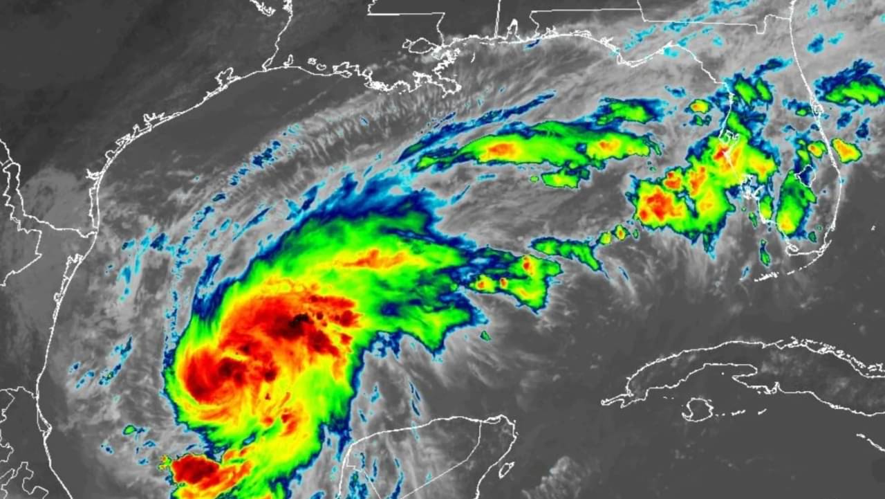
Tropical Storm Isaias intensified rapidly across the warm waters of the Gulf of Mexico on Wednesday, October 7, 2026, threatening the northern Gulf Coast as the system approaches hurricane strength. Forecasters warn the storm could reach sustained winds of 110 mph (177 km/h), placing the cyclone just below the 111 mph threshold required for a major Category 3 hurricane before it reaches land.
The National Hurricane Center issued hurricane watches spanning from Bay St. Louis, Mississippi, to Indian Pass, Florida, urging coastal communities to finalize preparations ahead of deteriorating conditions. “There is an increasing risk of dangerous wind and storm surge impacts along portions of the northern Gulf Coast. Residents from Louisiana to the Florida Panhandle should closely monitor the latest forecast updates and ensure they have their hurricane plan in place,” the agency stated in an official advisory.
Projected path and landfall timeline for Tropical Storm Isaias
Meteorologists track the center of Tropical Storm Isaias moving northeastward after developing from Tropical Depression Nine early Wednesday morning at 04:00 CDT. Computer models indicate the system will achieve hurricane status on Thursday, October 8, 2026, as it draws energy from elevated water temperatures in the central Gulf. The current forecast trajectory directs the core toward the coastline between Gulf Shores, Alabama, and Pensacola, Florida, with landfall projected for overnight Friday, October 9, or early Saturday, October 10.
Recent tracking shifts steered the primary cone of circulation slightly east, sparing metropolitan New Orleans from a direct hit by the eyewall. Meteorologist Payton Malone of WWL-TV in New Orleans noted that the proximity remains “too close for comfort” for regional emergency planners, given the expansive wind field and potential for peripheral squalls. City and parish leaders confirmed that while overall structural threats to southeastern Louisiana decreased, peripheral rain bands and elevated water levels will still affect low-lying bayous and lakeshores.
Active weather watches across Gulf Coast states
Authorities across four states activated emergency alert networks to coordinate coastal defenses, storm drainage clearing, and potential evacuation orders along exposed barrier islands. The National Hurricane Center established coordinated warnings along several hundred miles of coastline:
Check out: Invest 92L threatens southern coast with heavy rain as storm formation odds reach 80 percent
- Hurricane Watch: In effect from Bay St. Louis, Mississippi, eastward to Indian Pass, Florida.
- Tropical Storm Watch: Covering the area from the Jefferson Parish and Plaquemines Parish boundary in Louisiana to Bay St. Louis, and east of Indian Pass to the Aucilla River in Florida.
- Storm Surge Watch: Stretching continuously from the mouth of the Mississippi River eastward to Yankeetown, Florida.
- Rainfall projections: General accumulations between 3 to 6 inches (75 to 150 mm) from southeastern Louisiana through the Florida Panhandle, with isolated localized peaks reaching 10 inches (250 mm).
- Storm surge projections: Water rises between 3 to 5 feet (90 to 150 cm) east of the Mississippi River, alongside 1 to 3 feet (30 to 90 cm) along the shores of Lake Pontchartrain.
Historic delay in the 2026 Atlantic hurricane season
The emergence of Tropical Storm Isaias as a potential hurricane represents an extraordinary meteorological anomaly for the Atlantic basin. The 2026 hurricane season marks the latest calendar date for the development of a first hurricane in the modern satellite observation era, which began in 1966. Archival climate records show that the previous record for the latest inaugural hurricane of an Atlantic season occurred on October 8, 1905, establishing a 121-year interval between comparable late-season developments.
The name Isaias previously entered circulation during the active 2020 Atlantic hurricane season, when a cyclone carrying the designation traveled through the Caribbean before moving up the eastern seaboard of the United States. Atmospheric scientists note that despite the quiet initial months of 2026, conditions across the Gulf of Mexico provided sufficient moisture, reduced wind shear, and high oceanic heat content to allow rapid intensification once the system consolidated from an open tropical disturbance into a closed circulation.
Impacts across southeastern Louisiana and the Florida Panhandle
Although the eye of the system remains aimed toward coastal Alabama and northwest Florida, emergency management personnel warned that tropical cyclones generate hazards far beyond their centers. Weather stations recorded sustained surface winds of 50 mph (85 km/h) in the intermediate advisory published by the National Hurricane Center on Wednesday, showing that the system organized quickly after forming southwest of the Gulf. Officials in Jefferson Parish stated that rainfall totals in the New Orleans metropolitan area may remain modest at approximately half an inch, but eastern parishes face sustained onshore flow that will push tidal waters against exterior levees.
Communities between Mobile Bay and Panama City are bracing for more severe conditions, including beach erosion, rip currents, and structural wind damage. Local port authorities initiated safety protocols for commercial shipping lanes, while offshore petroleum operators secured platform facilities. Flash flood watches are expected to expand inland across southern Alabama and southwestern Georgia as outer convective rain bands sweep across the region through the end of the week.
Variables remaining under observation as the cyclone nears land
Meteorologists emphasize that several critical variables remain unsettled before the system reaches the coast. Forecasters continue to evaluate divergent computer models regarding the exact intensity at landfall, with projections oscillating between an upper-end Category 2 storm with sustained winds of 100 to 105 mph and an intense borderline Category 3 hurricane carrying winds of 110 mph. Additionally, the precise geographic coordinate of landfall remains uncertain, with potential shifts possible between coastal Mississippi, the Alabama beaches, and the western reaches of the Florida Panhandle until reconnaissance aircraft complete additional research missions on Thursday.