
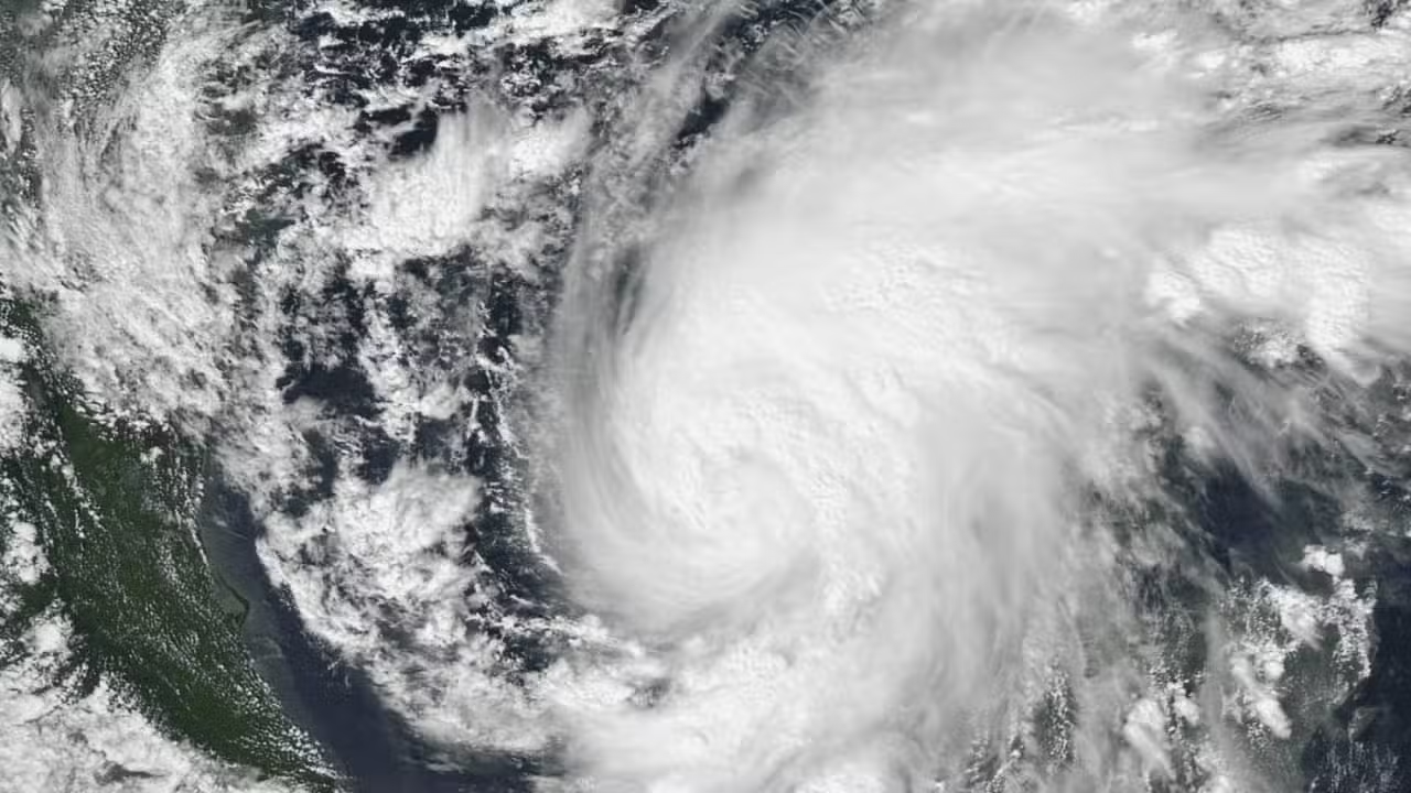
Violent sustained winds reaching 175 km/h (110 mph) battered the northern shoreline as Hurricane Isaias pushed dangerously close to the southeastern United States on Friday (9). Operating as a Category 2 system on the five-step Saffir-Simpson wind scale, the advancing storm knocked out electrical service to more than 365,000 residential and commercial utility accounts across Florida and Alabama. The sudden blackouts multiplied rapidly across barrier islands and low-lying coastal towns as outer rainbands snapped feeder cables and knocked down utility poles under escalating gale-force gusts.
The weather system had intensified into Category 3 strength over open waters before experiencing a slight reduction in peak sustained winds as it tracked directly toward the Florida Panhandle and coastal Alabama. By 7:00 p.m. Central local time (9:00 p.m. in Brasília) on Friday evening, public advisory bulletins from the National Hurricane Center placed the core of the circulation just miles offshore and on the verge of making landfall near Pensacola, in far western Florida. Coastal monitoring stations reported sharp atmospheric pressure drops and heavy squalls while emergency managers confirmed that onshore wind gusts were accelerating toward hurricane thresholds across the entire Pensacola metropolitan area.
Energy operations across the central and eastern Gulf of Mexico sustained severe disruptions as offshore operators enacted storm readiness protocols. Multinational petroleum corporations active in the basin, including Shell, Chevron, and BP, halted extraction drilling and evacuated non-essential offshore staff via helicopter transfers to secure mainland facilities. Bureau of Safety and Environmental Enforcement data indicated that these mandatory evacuations effectively shut down 62.9% of total daily crude petroleum extraction throughout the Gulf offshore production grid.
Ron DeSantis declares state of emergency across 27 counties in Florida Panhandle
Anticipating widespread wind damage and inland river overflows, Florida Governor Ron DeSantis issued a formal emergency declaration covering 27 counties situated along the northwestern corridor of the state. State administrations across neighboring Alabama and Georgia followed suit by issuing parallel disaster declarations alongside mandatory evacuation directives aimed at low-lying barrier islands and flood-prone shorelines. Emergency management officials instructed waterfront residents to pack essential belongings and travel inland along designated evacuation corridors before deteriorating conditions made coastal highways impassable.
Jamie Rhome, deputy director of the National Hurricane Center, issued an urgent briefing to Gulf Coast communities warning that life-threatening impacts would materialize during the overnight hours. “Things are going to get really, really dangerous over the next two hours,” Rhome stated during an official news briefing as the eyewall edged closer to coastal communities. Meteorologists stressed that the rapid deterioration of visibility and the sudden onset of hurricane-force gusts left zero room for late departures once the eyewall approached the beaches.
Local preparations to minimize property damage and protect family homes had begun several days prior to the cyclone’s direct landfall. Supermarket aisles across Pensacola and surrounding municipalities emptied of bottled water, canned goods, and portable batteries while long vehicle lines snaked around service stations as motorists queued to purchase gasoline. On Thursday (8), Pensacola Beach homeowner Steve Speirs spent hours fastening heavy steel storm shutters over his residential windows to safeguard his property against gale-force gusts and airborne projectile debris.
Storm surge warnings reach up to 9 feet as rail and air networks halt operations
Widespread transit disruptions brought commercial aviation and passenger rail service to an abrupt halt across the broader southern United States. National passenger rail carrier Amtrak suspended scheduled departures along its Mardi Gras line connecting New Orleans, Louisiana, to Mobile, Alabama, and instituted emergency route truncations on its long-distance Crescent passenger route. Commercial airports located throughout northwestern Florida grounded scheduled flights and halted tarmac ramp operations, while regional school boards ordered mandatory campus closures across districts falling inside hurricane warning zones.
See also: Jennifer Eckhart dies at 36 in Florida, authorities say
Forecasters emphasized that extreme oceanic storm surge driven ashore by prolonged wind pressure posed the most immediate threat to human life along coastal counties. Official marine flood models projected abnormal coastal sea surface rises between 1.5 and 2.7 meters (5 to 9 feet) above normal ground levels across vulnerable bays and estuaries. Civil defense authorities cautioned that these surges can trigger sudden, lethal flash flooding capable of washing away roadways, with danger exacerbated by spin-up tornadoes and widespread power line collapses as gales push farther inland.
Late season arrival sets historic Atlantic hurricane milestone following El Niño
Atmospheric records confirm that Isaias is the very first named system to reach hurricane strength across the Atlantic basin during the 2026 calendar year. The cyclone achieved hurricane categorization on Wednesday, October 7, 2026, establishing an unprecedented delay in hurricane genesis that researchers had not observed in more than a century. Climatologists noted that an Atlantic basin season waiting until October to generate its opening hurricane had not occurred in official meteorological archives since 1905.
The pronounced midsummer lull in tropical cyclone activity stemmed primarily from a strong El Niño pattern dominating equatorial Pacific Ocean surface temperatures and reshaping broader atmospheric circulation. Strong vertical wind shear produced by this planetary climate oscillation swept across the Caribbean and tropical Atlantic, tearing apart developing cloud clusters and preventing tropical waves from consolidating into organized rotating storms until early autumn.
Long-range forecast tracks released by meteorological agencies indicate that the vortex of Hurricane Isaias will migrate northward through the interior of Alabama during Saturday (10) before weakening gradually toward the Tennessee River Valley. Forecasters at the National Hurricane Center noted that verifying the precise point and minute of landfall along the beachfront remained tied to late-evening radar tracking, while rescue personnel and local first responders prepared to initiate damage assessments as soon as sustained winds dropped below tropical storm force.