7.5 Earthquake Shakes Chile and Argentina, Triggers Tsunami Alert in Magallanes Por Luís Henrique Costa
11 min de leitura
 |
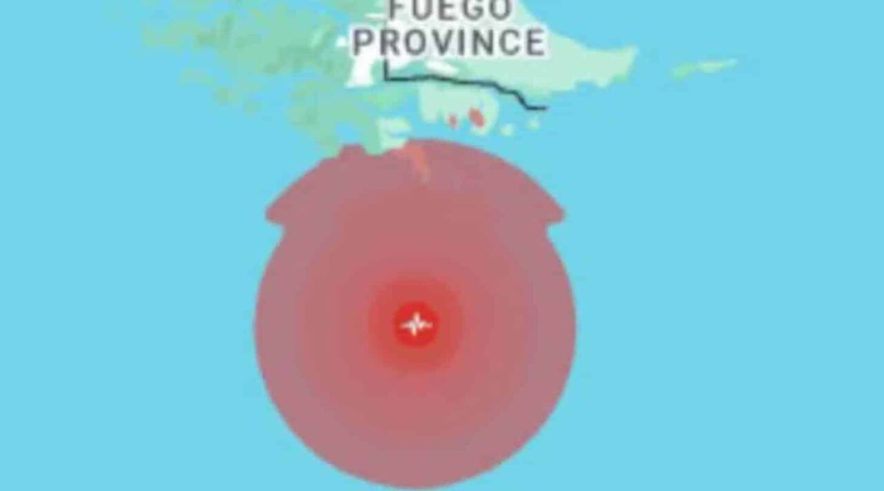
A powerful 7.5 magnitude earthquake struck southern Chile on the morning of Friday, May 2, 2025, prompting an immediate response from authorities. The quake, recorded at 8:58 a.m. local time, had its epicenter 218 kilometers south of Puerto Williams in the Magallanes region, near the Drake Passage between Cape Horn and Antarctica. The shallow depth of the tremor, just 10 kilometers beneath the seabed, heightened concerns about potential tsunamis. Coastal evacuations were ordered in record time.
The National Disaster Prevention and Response Service (Senapred) of Chile acted swiftly, urging residents to abandon coastal areas of Magallanes and beaches in the Chilean Antarctic territory. Tsunami sirens echoed in cities like Punta Arenas and Puerto Williams, while social media videos showed residents calmly moving to higher ground. President Gabriel Boric, a native of Punta Arenas, emphasized the severity of the situation, urging the public to follow official instructions.
Siga o Mix Vale no Google e veja nossas notícias primeiro
The seismic event was also felt in southern Argentina, particularly in Ushuaia, Tierra del Fuego, where preventive evacuations took place. The epicenter’s proximity to the Drake Passage, one of the planet’s most turbulent regions, raised the alert level. Chilean and Argentine authorities are closely monitoring the possibility of significant waves, with initial estimates suggesting tsunamis of 1 to 3 meters in coastal areas.
- Quake magnitude: 7.5 on the Richter scale, per Chile’s National Seismological Center.
- Epicenter location: 218 km south of Puerto Williams, at 10 km depth.
- Affected areas: Magallanes coastal regions, Chilean Antarctic territory, and southern Argentina.
- Initial response: Immediate evacuation ordered by Senapred and activation of the Disaster Risk Management Committee (COGRID).
Mass evacuation in Magallanes region
The evacuation order issued by Senapred covered the entire Magallanes coast, including cities like Punta Arenas, Puerto Williams, and areas of the Chilean Antarctic territory. In Punta Arenas, one of the region’s largest cities, thousands left their homes and headed to designated safe zones in elevated areas. Tsunami sirens, installed after previous seismic events, were activated minutes after the quake, ensuring rapid public alerts.
Chile’s Hydrographic and Oceanographic Service (SHOA) estimated that potential tsunami waves could reach the Magallanes coast and Antarctic bases in the hours following the quake. In Puerto Williams, known as the world’s southernmost city, the evacuation was orderly, with residents moving to pre-designated safe areas. No reports of casualties or significant property damage have emerged, but authorities remain vigilant for possible aftershocks.
- Safety measures: Evacuation of coastal areas and Antarctic beaches.
- Priority locations: Punta Arenas, Puerto Williams, and Chilean Antarctic bases.
- Wave estimates: Tsunamis of 1 to 3 meters, per NOAA reports.
Epicenter details in Drake Passage
The earthquake’s epicenter was located in the Drake Passage, a region notorious for extreme maritime conditions and deep ocean waters. Situated between Cape Horn, at the southern tip of South America, and the Antarctic Peninsula, the passage is one of the planet’s most seismically active areas due to the interaction between the Antarctic and South American tectonic plates. The quake’s shallow depth of 10 kilometers increased the potential for tsunami formation, as tremors near the surface often displace large volumes of water.
The United States Geological Survey (USGS) confirmed that the quake was felt in distant areas, including Ushuaia, Argentina, approximately 219 kilometers from the epicenter. The Drake Passage, with its strong currents and intense winds, is a critical region for navigation, and the quake led to a temporary suspension of maritime activities. Ships and vessels were instructed to remain in deeper waters to avoid potential waves.

Immediate response from Chilean government
President Gabriel Boric canceled his official schedule to oversee the emergency from La Moneda Palace in Santiago. In a social media post, Boric stressed the importance of following authorities’ guidance and confirmed that the Disaster Risk Management Committee (COGRID) was activated at regional and national levels. All state resources, including emergency teams and armed forces, were deployed to support affected areas.
Senapred dispatched teams to assess potential damage to infrastructure, utilities, and properties, though initial reports suggest minimal material impact so far. The authorities’ priority is ensuring that residents remain in safe areas until the tsunami risk is ruled out. Senapred’s deputy director of management, Miguel Ortiz, noted in a press conference that the evacuation was carried out efficiently but urged Magallanes residents to stay vigilant due to the possibility of aftershocks.
- Government actions: Activation of COGRID and mobilization of state resources.
- Monitoring: Damage assessments and vigilance for aftershocks.
- Communication: Alerts via sirens and social media updates.
- Leadership: President Boric oversees the situation from Santiago.
Impact in southern Argentina
The earthquake also had repercussions in southern Argentina, particularly in Tierra del Fuego province. In Ushuaia, the city closest to the epicenter, local authorities ordered preventive evacuations in coastal areas. Residents reported feeling the tremor for several seconds, but no significant damage to infrastructure or buildings has been reported. The geographical proximity to Chile prompted coordination between the two countries to monitor the situation.
Argentina’s National Institute of Seismic Prevention (INPRES) confirmed that the quake was recorded with a magnitude similar to Chile’s reports but with lower intensity on Argentine soil. The evacuation in Ushuaia was carried out as a precaution, given the region’s exposure to tsunami risks due to its southern location. No casualties or material damage have been reported by Argentine authorities.
Seismic history of the region
The Magallanes region and the Drake Passage lie in a zone of high tectonic activity, where the Antarctic plate subducts beneath the South American plate. Significant quakes are not uncommon, but the epicenter’s proximity to inhabited areas like Puerto Williams makes this event particularly notable. Over the past century, the region has recorded at least 15 earthquakes with magnitudes above 7, according to historical data.
One of the most notable events was the 1949 earthquake, with a magnitude of 7.8, which also triggered a tsunami in the region. Though less devastating than other historical quakes in Chile, such as the 1960 Valdivia earthquake, the 1949 event laid the groundwork for modern alert and evacuation systems. Lessons from past events contributed to the swift response of authorities in 2025, with established sirens and protocols.
- Historical events: 1949 earthquake (magnitude 7.8) with tsunami.
- Seismic frequency: 15 quakes above magnitude 7 in 100 years.
- Tectonic plates: Antarctic and South American in the Drake Passage.
Tsunami prevention measures
Chile boasts one of the world’s most advanced tsunami alert systems, developed through decades of experience with natural disasters. The Hydrographic and Oceanographic Service (SHOA) employs a network of ocean buoys and sensors to detect sea level changes, enabling alerts within minutes. Following the 2010 earthquake that devastated central Chile, the government invested in monitoring infrastructure and public education.
In Magallanes, tsunami sirens are regularly tested, and residents are trained to evacuate coastal areas during emergencies. Safe zones and evacuation routes are mapped out in cities like Punta Arenas and Puerto Williams, facilitating organized responses. SHOA estimated that the first waves could reach Magallanes’ coast within 30 minutes to an hour after the quake, underscoring the urgency of the evacuation.
Monitoring in Antarctic bases
The earthquake also impacted Chile’s Antarctic territory, where scientific bases operate year-round. The Chilean Antarctic Institute (INACH) reported that bases were evacuated as a precaution, with researchers and staff relocated to safe areas. Antarctica’s coastal geography makes it particularly vulnerable to tsunamis, and Chilean authorities prioritized personnel safety.
Chilean bases, such as Frei Montalva Station, are equipped with communication systems for real-time coordination with the mainland. SHOA warned that tsunami waves could reach the Antarctic Peninsula, though the absence of permanent populations reduces the risk of human harm. The evacuation of bases was completed without incident, and monitoring continues to assess potential damage to scientific equipment.
- Affected bases: Frei Montalva Station and other Chilean facilities.
- Measures: Evacuation of researchers to safe areas.
- Risks: Potential damage to scientific equipment in Antarctica.
Potential for aftershocks
Experts warned that aftershocks are expected following a 7.5 magnitude earthquake, particularly in a tectonically active region like the Drake Passage. Senapred advised Magallanes residents to remain in safe areas until the risk of further tremors is ruled out. Minor aftershocks have already been recorded in the hours following the main quake, but none have caused additional damage.
The USGS noted that aftershocks could persist for days or weeks, with magnitudes ranging from 4 to 6 on the Richter scale. Chilean authorities are using seismographs and real-time data to monitor seismic activity and inform the public of potential risks. Preparations for aftershocks include inspecting critical infrastructure, such as bridges and roads, in the Magallanes region.
International coordination
The earthquake’s proximity to Argentina prompted immediate cooperation between the two countries. Chilean and Argentine authorities exchanged information on the quake and tsunami risks, ensuring synchronized evacuation measures. The Pacific Tsunami Warning Center, based in Hawaii, issued a statement warning of possible waves in other Pacific Ocean regions, though the risk is considered low.
International organizations, such as the UN and the Organization of American States (OAS), offered support to Chile for potential humanitarian needs. The Chilean government has stated that the situation is under control but remains open to international collaboration if the emergency escalates.
- Cooperation: Information exchange between Chile and Argentina.
- Global alerts: Statement from the Pacific Tsunami Warning Center.
- International support: UN and OAS ready to assist.
Public preparedness
The response from Magallanes residents was marked by calm and organization, reflecting years of disaster preparedness campaigns. Schools, businesses, and households in the region regularly participate in evacuation drills, which facilitated protocol execution during the earthquake. In Puerto Williams, volunteers assisted the elderly and those with reduced mobility in reaching safe zones.
Social media played a key role in disseminating information, with authorities and citizens sharing real-time updates. Videos from Punta Arenas showed lines of cars heading to elevated areas as sirens blared. Chile’s experience with previous earthquakes, such as the 2015 Illapel quake, contributed to the efficiency of the collective response.
Technology in disaster response
Chile has heavily invested in technology for seismic and tsunami monitoring over the past decades. In addition to SHOA’s ocean buoys, the country uses mobile apps that send automatic alerts to residents during tremors. These systems were critical to the rapid evacuation of Magallanes, with messages dispatched minutes after the quake.
The National Seismological Center at the University of Chile operates a nationwide seismograph network, enabling 24/7 monitoring. Collected data is shared with international agencies like the USGS for broader seismic analysis. The integration of technology ensured that the 2025 earthquake was detected and communicated in record time.
- Technologies used: Ocean buoys, seismographs, and mobile apps.
- Involved institutions: SHOA, National Seismological Center, and USGS.
- Benefits: Rapid alerts and efficient evacuation.
Current situation
Chilean authorities continue to monitor the situation, with emergency teams stationed in Magallanes and the Antarctic territory. SHOA maintains the tsunami alert, though preliminary reports suggest that initial waves, if they occur, will be of low amplitude. Residents of Punta Arenas, Puerto Williams, and other evacuated areas remain in safe zones, awaiting official clearance to return.
The Argentine government also remains on alert, with Ushuaia maintaining preventive measures. The absence of significant damage or casualties so far reflects the effectiveness of the measures taken. President Boric is expected to deliver an official statement in the coming hours, outlining the next steps in the emergency plan.