Curiosity robot photographs 20-centimeter cylindrical object on Mars and mobilizes scientists
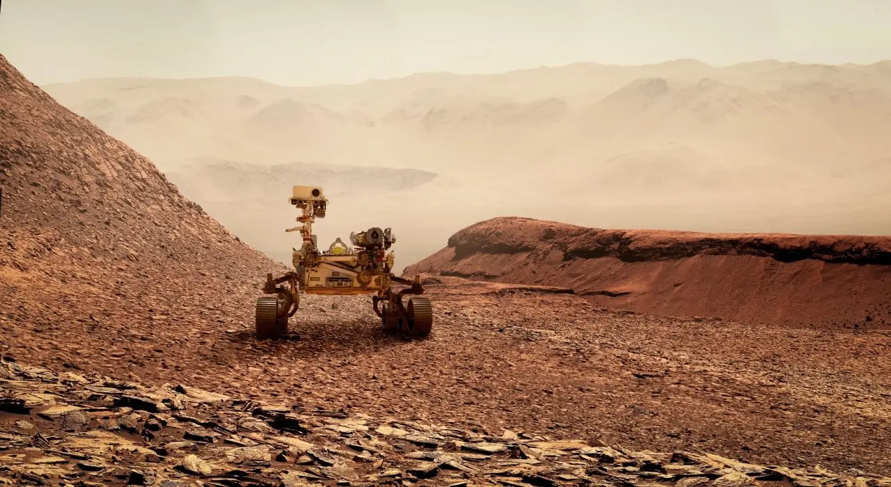
Continued exploration of the red planet has revealed a peculiar element that has caught the attention of experts in planetary geology and astrobiology. The robotic vehicle Curiosity recorded images of a perfectly outlined cylindrical shaped object resting on the dusty and rocky surface. The photographic record took place in the region known as Cratera Gale, an area that has been the subject of rigorous scientific scrutiny due to its rich history of sedimentary formations. The initial discovery occurred during routine high-resolution photographic mapping of the terrain.
The artifact is approximately twenty centimeters long and has remarkably flat ends, characteristics that clash with the irregular rock formations prevalent at the site. The position of the cylinder, housed in a small depression in the slope of Monte Sharp, suggests that it has been physically stable for a considerable period. The absence of rolling marks or disturbances in the adjacent soil reinforces the idea that the object has not moved recently due to wind action. The visual contrast with the surrounding environment made the anomaly immediately evident in data transmissions.
The detection generated technical debates about the origin of the structure, dividing hypotheses between natural erosion processes and rare mineral anomalies. Especialistas in space images often alert to visual phenomena that lead observers to identify familiar shapes in random patterns of nature. The detailed investigation requires the crossing of photographic data with spectrometric analyzes to determine the exact composition of the material found. The rigor of the scientific method requires that all geological variables be exhausted before any definitive classification can be made.
Physical details of the surface anomaly
The morphological analysis of the object reveals an unusual symmetry for rocks shaped exclusively by Martian wind erosion, which usually generates pointed or faceted shapes known as ventifacts. The smooth cylindrical shape requires very specific environmental conditions to form naturally, generally involving the precipitation of minerals in pre-existing cylindrical cavities that are subsequently exposed by degradation of the bedrock. The vehicle’s imaging equipment, especially the mast cameras, were recalibrated to capture different angles of solar incidence on the part. Essa variation in lighting allows researchers to assess the texture of the cylinder’s surface and identify possible mineral veins or microscopic fractures. The accuracy of these images is essential to rule out the possibility of digital compression artifacts or failures in the probe’s optical sensors. Crossing this visual information with topographic data helps to reconstruct the depositional history of that specific fragment.
The exact location of the find provides crucial clues about the sediment transport mechanisms that have operated in the region over billions of years of planetary activity. Monte Sharp, a central elevation within the crater, is composed of overlapping layers of sedimentary rocks that serve as a chronological record of Martian climate change. The cylinder was found on a hillside where younger material is exposed to constant abrasion from dust particles suspended in the thin atmosphere. The dynamics of local winds create wear patterns that normally do not result in such regular and polished geometries. The presence of rounded pebbles nearby indicates that the area was once the bed of ancient water flows, raising the hypothesis that the object may be a mineral concretion rolled by extinct water currents. The site’s stratigraphy continues to be mapped millimeter by millimeter to contextualize the anomalous rock. The ongoing mapping effort requires precise coordination between navigation teams and the geologists responsible for interpreting the raw data. The integration of these disciplines ensures that no environmental evidence goes unnoticed during site assessment. The scientific validation process requires patience and extreme methodological rigor.
The ground operations team identified unique aspects that justify increased attention to the cylindrical artifact:
– The exact proportion between the length and diameter of the structure resembles specific crystalline formations.
– The color of the object’s surface has a different albedo than the basaltic gravel that makes up the immediate soil.
– The absence of similar fragments within a radius of several meters suggests an isolated deposition event.
Exploration vehicle operations
The equipment responsible for the capture landed on the planet in mid-2012 with the primary mission of investigating the past habitability of the Martian environment. Equipado with a mobile analytical laboratory, the vehicle has already covered dozens of kilometers overcoming rough terrain and severe sandstorms. The durability of mechanical and electronic systems has exceeded all initial engineering estimates. The original project envisaged a much shorter lifespan for the locomotion systems.
Discoveries accumulated over the years include the identification of complex organic molecules and the confirmation that lakes of liquid water once existed on the surface. Drilling sedimentary rocks allowed the extraction of powdered samples that were heated and analyzed internally by the probe’s instruments. Esses complex procedures are executed autonomously upon receipt of command packets sent from Terra. Communication suffers significant delays due to interplanetary distance.
Cratera Gale rock formations
The impact basin where exploration takes place has a vast diameter, housing a central mountain that rises miles above the crater floor. The lower layers of this mountain contain clay minerals that form exclusively in the presence of water with a neutral pH. The transition to sulfate-rich upper layers marks a global climate change that has dried out the planet. Studying this transition is vital to understanding local atmospheric evolution.
The geological structures found vary from thin sheets of mudstone to conglomerates of stones cemented by precipitated minerals. The action of groundwater, long after surface lakes dried up, continued to alter the chemistry of buried rocks. Mineral-rich Fluidos flowed through fractures, depositing hard materials that resist erosion more than the surrounding rock. Quando the wind removes the soft material, these mineral veins are exposed in high relief.
Leia Também


Spherical and cylindrical concretions are common byproducts of this type of diagenetic activity in sedimentary environments. Na Terra, arid deserts feature analogous formations where precipitation of iron or silica oxides creates massive stone tubes and spheres. Comparison with these terrestrial analogues provides a robust working model for planetary geologists. Morphological similarity helps narrow formation hypotheses without the need for direct physical intervention.
Isotopic analysis of the rocks surrounding the cylinder can reveal the temperature and composition of the water that once flowed there. The probe’s internal laboratory measures the ratio of heavy and light isotopes of elements such as carbon and oxygen. Essa chemical signature functions as a fingerprint of environmental conditions in the distant past. The precision of these measurements is what sets modern geology apart from simple visual observation.
Visual phenomena and interpretations
The history of planetary observation is replete with instances where natural geological features were initially mistaken for man-made artifacts due to low image resolution or misleading lighting angles. The psychological phenomenon of pareidolia causes the human brain to impose known patterns, such as faces or perfect geometric objects, onto purely chaotic visual stimuli. A classic example occurred in the 1970s, when orbital probes photographed a mountain that resembled a human face, an illusion that was later dispelled by high-definition cameras that revealed it to be just an eroded hill. Caution in interpreting raw images has become a fundamental pillar of scientific communication to avoid the spread of unfounded theories. Rigor demands that an object’s geometry be confirmed by multiple sensors before any formal declaration.
Recently, other missions operating in different regions of the planet also recorded visual anomalies that required detailed investigation to demystify them. Rochas with zebra-like striped patterns, shiny metallic meteorites, and even debris generated by humans’ own landing equipment have been cataloged by navigation teams. The identification of sampling tubes discarded by more recent probes illustrates how the presence of anthropogenic material is already part of the local landscape. Differentiating between what is native to the planet, what is terrestrial space debris and what is an optical illusion depends entirely on the analytical capacity of the instruments on board. Transparency in the release of these raw images allows the global community to actively participate in the visual screening process.
Technological advances for remote analysis
The ability to investigate geological anomalies millions of kilometers away is based on a sophisticated suite of remote sensing instruments that have evolved significantly in recent decades. Modern exploration vehicles use pulsed laser systems capable of vaporizing small portions of rock several meters away, generating a luminous plasma that is immediately analyzed by precision spectrometers. Essa technique allows identifying the elemental composition of inaccessible or fragile targets without the need to physically move the robot, saving time and vital energy for the mission. The integration of artificial intelligence algorithms into onboard computers has optimized the target selection process, allowing the probe itself to identify rocks with unusual chemical signatures and prioritize their analysis during periods of inactivity of the teams on Terra. Câmeras multispectral capture images at wavelengths invisible to the human eye, revealing the distribution of hydrated minerals and metallic oxides spread across the surface. The articulated robotic arm, equipped with magnifying lenses and cleaning brushes, complements remote analysis by allowing direct contact with surfaces previously selected by the lasers. Sensores meteorologists attached to the masts continuously monitor atmospheric pressure, ultraviolet radiation and wind speeds, providing the environmental context necessary to understand current erosion rates. The miniaturization of electronic components has made it possible to embed true X-ray diffraction laboratories in the chassis of vehicles, replicating analyzes that were previously only possible in large terrestrial installations. The redundancy of the systems ensures that isolated sensor failures do not compromise the overall analytical capacity of the exploratory platform. Toda this technological architecture operates under extreme temperature and radiation conditions, demonstrating the pinnacle of materials engineering applied to scientific research.
Preparations for the return of materials
Space agencies’ strategic planning involves the future collection and sending of rock fragments and soil samples back to terrestrial laboratories. Essa complex interplanetary logistics aims to overcome the weight and energy limitations of miniaturized instruments sent into space. The analysis of samples in terrestrial soil will allow the use of state-of-the-art particle accelerators and scanning electron microscopes. The structural integrity of the collected samples is maintained in hermetically sealed titanium tubes.
Continuous orbital monitoring
Surface exploration is constantly supported by a fleet of satellites orbiting the red planet, providing ultra-high-resolution topographic maps and real-time climate data. Esses orbiters function as communications relays, receiving the heavy photo data packets from the surface vehicles and sending them to the receiving antennas on the Terra. The synergy between macroscopic orbital vision and microscopic analysis on the ground is essential for successful operations.
Ground-penetrating radars on board satellites can detect subsurface ice deposits and map the deep geological structure of craters. Essa three-dimensional view of terrain helps mission planners plot safe routes for robots, avoiding treacherous dune fields and unstable slopes. Continuous observation from space also allows monitoring of global dust storms that can affect equipment’s solar power generation.
Joint efforts in planetary exploration
The complexity and high cost of interplanetary exploration have driven the formation of international consortia involving multiple space agencies and academic research institutions. Sharing propulsion technologies, autonomous navigation systems and scientific measuring instruments reduces financial risks and expands data collection capacity. Engenheiros from different continents work in synchronized shifts to maintain uninterrupted operation of the exploration vehicles.
The public availability of raw image catalogs has allowed the emergence of a global network of citizen scientists who dedicate their time to the detailed analysis of thousands of photographs. Esses volunteers often identify subtle geological features, like the eight-inch cylinder itself, even before official data analysis teams. Collaborative image processing accelerates the screening of targets of scientific interest.
The integration of small autonomous helicopters into surface missions has revolutionized aerial reconnaissance capabilities in thin atmospheres. Esses drones operate as forward scouts, photographing areas inaccessible to wheeled vehicles and providing three-dimensional models of the terrain ahead. The combination of ground mobility, low-altitude aerial reconnaissance and orbital monitoring creates a planetary observation network unprecedented in the history of science.