
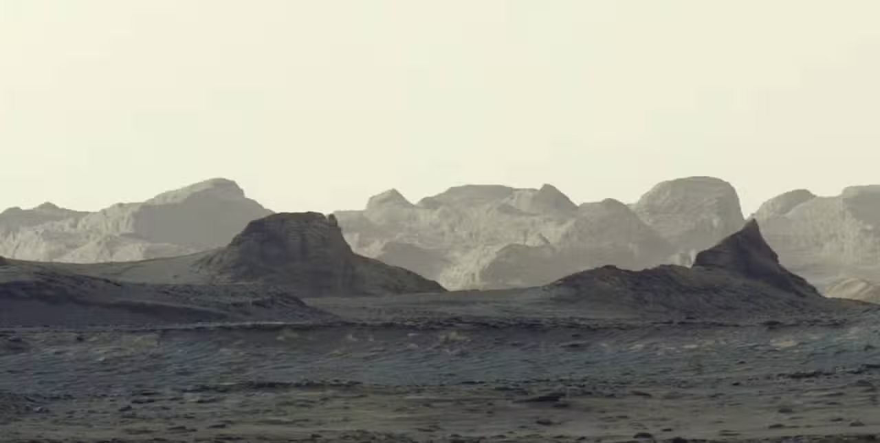
NASA’s Curiosity rover captured an unprecedented panoramic view of early morning light breaking over distant, wind-sculpted rock formations on Mars, revealing geological details billions of years old. The image captures the rugged yardangs along the slopes of Mount Sharp in the interior of Gale Crater. The United States space agency and the Jet Propulsion Laboratory published the mosaic on Tuesday, October 6, 2026, showing the Martian landscape under natural lighting conditions rarely seen in planetary exploration imagery.
Ashwin Vasavada, Curiosity project scientist at the Jet Propulsion Laboratory in Pasadena, California, emphasized the contrast between these elevated formations and the terrain explored by the vehicle over the past decade. “The bright craggy peaks in the distance are a rock layer that is quite different in appearance from all the layers the rover has driven through so far,” Vasavada stated upon the public release of the composite scene.
Follow: NASA JPL highlights Saturn opposition and Orionid meteors
Mastcam mosaic reveals natural Martian morning light
The Mast Camera, built and operated by Malin Space Science Systems in San Diego, California, gathered the component frames on Tuesday, August 11, 2026. The recording occurred at approximately 8:30 a.m. local solar time on Mars, marking the 4,982nd Martian day, or sol, since the vehicle touched down on the surface. Engineers in California assembled the final panoramic mosaic from six individual Mastcam frames after transmitting the telemetry back to Earth.
Read also: GIMLI lunar mission selected by NASA to inspect Marius Hills Pit
Planetary scientists processed the mosaic without the traditional white-balance adjustment commonly applied to space photography. Standard color calibrations balance Martian imagery to simulate midday lighting under terrestrial skies, which helps geologists recognize mineral compositions. By bypassing that color calibration step, the team retained bluish tones in the foreground sand and recorded the true illumination produced by the low morning sun filtering across the arid atmosphere.
Yardangs form when persistent winds carrying sand and dust particles scour bedrock surfaces across millions of years, carving aligned ridges with shapes often compared to inverted boat hulls. The distinct stratum visible in the background spans across the northwest shoulder of Mount Sharp, forming an extensive field of steep cliffs and sharp crests that rise above the sedimentary deposits of Gale Crater.
Key measurements of the Curiosity mission and the yardang formation
- 4,982 — Martian solar day, or sol, on which Curiosity took the dawn photographs
- 8:30 a.m. — local solar time on Mars during the acquisition of the exposures
- 6 — individual Mastcam frames combined to create the panoramic view
- 16 kilometers — total lateral span of the yardang formation across Mount Sharp
- 5 kilometers — total vertical height of Mount Sharp from the floor of Gale Crater
- 1 kilometer — total cumulative elevation gained by Curiosity during its mountain ascent
- 3 billion years — estimated age of the rock deposits comprising the yardang layer
Curiosity sets an elevation record on Mount Sharp
Curiosity achieved a cumulative vertical elevation gain of 1 kilometer along the slopes of Mount Sharp, representing the highest altitude reached by any mobile vehicle on another planet. The six-wheeled rover originally landed inside Gale Crater on Monday, August 6, 2012, and began ascending the central mountain in 2014. Mount Sharp, formally designated Aeolis Mons, stands 5 kilometers tall and consists of layered sedimentary mounds that record billions of years of environmental change, documenting the transition of ancient Mars from a wet environment of rivers and lakes into a dry desert.
Keep reading: NASA Curiosity records rocks on Mars sculpted by billion-year-old winds
The rover is operating in the second year of its fifth extended mission phase, navigating across terrain heavily enriched with mineral salts, sulfates, and carbonates left behind as surface waters evaporated. These chemical signatures mark the drying phases of the crater lake system, providing clues about whether microbial life could have survived during the planet’s climatic shifts.
Over the next year, navigation teams plan to guide the rover through these sulfate-bearing units toward the base of the yardang layer. Mission planners at the Jet Propulsion Laboratory expect the vehicle to reach the lower boundaries of the yardang cliffs in 2027, where its robotic arm and percussion drill can directly sample rock powdered from the enigmatic structures.
Scientific questions surround the origins of the 16-kilometer layer
“The yardang layer looks out of place. It’s the wrong color, the layers tilt at an odd angle, and it almost appears plastered on. But that’s what makes it exciting to reach. No one is sure exactly what created this layer, but one idea is it may be ash deposited by ancient volcanic eruptions,” Vasavada explained.
The geological origin of the yardang unit remains unconfirmed by planetary researchers. Scientists evaluate competing hypotheses, including ancient explosive volcanic events that laid down thick beds of consolidated ash, or massive windblown sand deposits that underwent cementation under distinct geochemical conditions. Direct contact science using Curiosity’s analytical instruments will be necessary to resolve the composition and origin of the yardangs once the vehicle arrives at the formation.