

Japão’s Agência Meteorológica issued level 4 flood warnings for several rivers in the Japanese capital this morning. The Kanda, Meguro and Zenpukuji rivers are among those affected by the heavy rains caused by the typhoon. Level 4 indicates high danger and recommends that residents in risk areas immediately evacuate dangerous locations.
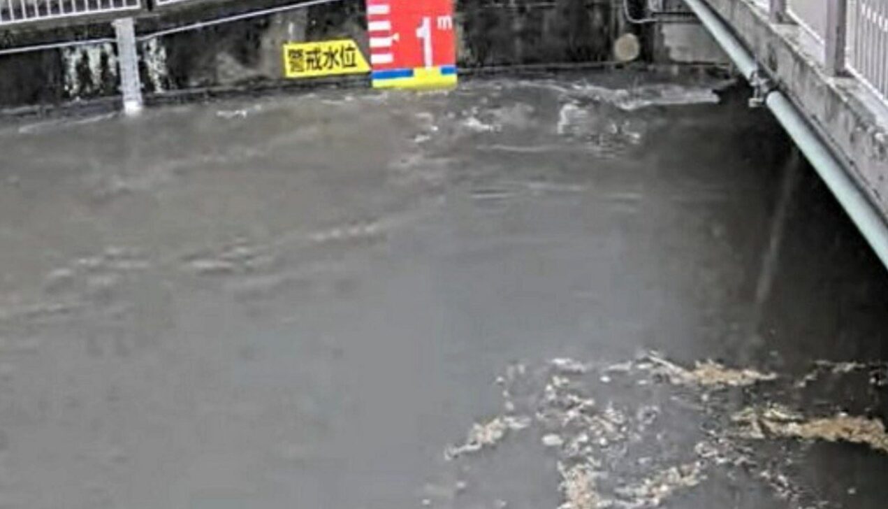
Equipes monitor the volume of water in rivers from the early hours of the day. Câmeras live shows the Zenpukuji river at a high level in Suginami’s neighborhood at around 7:30 am. Intense Chuvas falls over the Kanto region since dawn.
Typhoon Chuvas increases river volume by Tóquio
The typhoon, identified as Jangmi or Tufão nº 6, advances through the east of the country and brings heavy precipitation to the Kanto region. The volume of rain accumulated in the last few hours increased the risk of overflow in urban watercourses.
Em Tóquio, Suginami, Setagaya, Meguro, Shinagawa, Nakano, and Bunkyo districts have registered the specific alerts. The Nogawa river and the Sengawa river also entered the intensified monitoring list.
- Rios with alert level 4 on Tóquio: Kanda, Meguro, Zenpukuji, Nogawa and Sengawa
- Distritos most affected: Suginami, Setagaya, Meguro, Shinagawa, Nakano and Bunkyo
- Recomendação main: evacuate low-lying areas near rivers
The five-level alert system recently came into effect on Japão. Level 4 corresponds to the phase in which local governments can issue evacuation orders.
Nível 5 registered to Wakayama and then demoted
In Wakayama province, Agência Meteorológica issued level 5 alert for the Kozagawa river at 5:35 am. Esse is the highest degree on the scale and signals that disaster has already occurred or is imminent.
The alert was downgraded to level 2 before 9am. Mesmo thus, flooding was recorded in the cities of Kozagawa and Kushimoto. The Kozagawa river passes through these locations.
Moradores reported water invading streets and homes. Authorities are monitoring the damage caused by the flood.
Coletiva press release highlights gradual increase in risk
Takuya Hosomi, head of the Agência Meteorológica prediction division of Japão, spoke at a press conference at 6:30 am. Ele reported that rain clouds gradually cover the regions of Kanto and Tokai.
“The danger level will gradually increase from now on. Pedimos may you remain extremely vigilant,” the officer said. Chuvas strong landslides and landslides were also reported in parts of Kanto, Tokai and Kinki.
The forecast indicates that the volume of rain is expected to continue over the next few hours. Especialistas monitor the movement of the tropical system.
Impacto in urban areas and safety recommendations
Tóquio has a high population density in regions close to rivers. Autoridades advises people to avoid low-lying areas, underpasses and riverbanks.
The level 4 alert serves as a signal for residents to move to higher ground. The new alert system unifies information about heavy rain, landslides and river overflows.
Equipes of civil defense operate in critical points. Até At the moment, there is no record of major flooding in the capital, but monitoring remains constant.
Histórico recent heavy rains in Japão
The country experiences frequent episodes of extreme precipitation during the typhoon season. The updated alert system aims to provide greater clarity to the population about the seriousness of each situation.
Nível 5 indicates imminent or ongoing disaster. Nível 4 calls for precautionary evacuation. The lowest levels serve as initial warnings.
Agência Meteorológica reinforces the importance of following local guidelines. Famílias must have evacuation plans ready in times of climate risk.