

An earthquake of magnitude 7.8 hit the south coast of the island of Mindanao, in Filipinas, on Monday morning. The main tremor occurred at exactly 7:37 am local time, with the epicenter located in the vicinity of Sarangani province. The shallow depth of the geological event amplified the force of the surface impact. Local Autoridades confirmed collapses of commercial and residential structures in the first few minutes. Emergency Equipes began search operations for survivors under the rubble. The phenomenon also triggered international alerts after waves formed towards other Asian countries.
Epicentro and destruction in Sarangani’s province
The city of General Santos recorded the largest structural damage documented to date. Public Edifícios presented partial collapses and bridges essential for logistical flow suffered severe cracks. The force of the tremor interrupted electricity supply in multiple neighborhoods. Preliminary Relatórios from the Philippine government indicates dozens of injuries caused by falling materials and debris. The scenario is critical. Hospitais in the region operate at maximum capacity to care for patients who arrive with physical trauma.
Profissionais from the rescue team face access difficulties in areas isolated by landslides. The mobilization of heavy machinery began to clear the main roads and allow ambulances to pass. The police contingent was called in to isolate risk areas and prevent civilians from approaching buildings about to collapse. The rapid response from public health fronts attempts to minimize the worsening of the clinical condition of the injured rescued in the first hours.
The Instituto Filipino of Vulcanologia and Sismologia maintains constant monitoring of the affected area. Mais of one hundred aftershocks were detected in the hours following the mainshock. Algumas of these secondary vibrations had enough strength to compromise buildings already weakened by the first impact. Official guidance dictates that residents remain out of closed spaces that show any sign of structural instability.
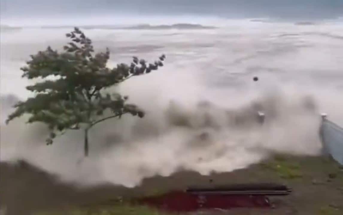
Alertas of tsunami and reflections in neighboring countries
The sudden displacement of tectonic plates on the ocean floor generated a significant change in sea level. Centro of Alerta of Tsunamis of Pacífico issued immediate warnings to the coastal nations of the Asian region. Indonésia confirmed the arrival of waves of up to 75 centimeters in Ilhas Sanjaya, located in the Sulawesi province of Norte. The phenomenon occurred before 10:30 am, considering the reference time zone adopted by maritime monitoring agencies.
Outras official measurements recorded variations in tidal behavior in different territories. Data collected by ocean buoys and coastal stations indicated the following impacts:
- Elevação of 46 centimeters off the coast of Davao, in Philippine territory.
- Ondas of 17 centimeters reaching the port region of Bitung, in Indonésia.
- Tsunamis of 30 centimeters observed in the port of Miyazaki, in Japão.
- Pequenas sea level changes detected in the Palau archipelago.
- Variações between 10 and 20 centimeters at other stations in southern Japan.
Japão and Indonésia authorities activated preventive evacuation protocols in the highest risk areas. Sirenes sounded in fishing communities to ensure the quick departure of inhabitants towards high points. Até At the moment, neighboring governments have not reported catastrophic damage caused solely by the ingress of water. The Indonesian meteorological agency continues to monitor the dissipation of ocean energy to rule out new dangers.
Rescue Mobilização and Infrastructure Impact
The Filipinas central government ordered the release of emergency funds for city halls affected by the disaster. Local Presidentes took over logistical coordination for the distribution of drinking water, non-perishable food and medical supplies. The interruption of basic services affects thousands of families who had to leave their homes in a hurry. Temporary Abrigos were set up in gymnasiums and public squares far from the sand strip and dangerous slopes.
Communication in the southern provinces has experienced intermittent failures due to falling transmission towers. Técnicos of telecommunications works to restore the internet and cell phone signal as quickly as possible. The recovery of networks is vital for the coordination of search and rescue teams operating in the field. Familiares use amateur radio networks to search for information about relatives who live in areas of greatest impact.
The Philippine early warning system has demonstrated effectiveness in warning the coastal population of imminent risk. Moradores reported receiving audible messages on their mobile devices minutes before the strongest tremor. Essa time window allowed many people to seek refuge in safe ground. The official count of fatalities and missing persons has not yet been finalized by the competent authorities, who prioritize active rescue.
Histórico seismic and monitoring on Anel of Fogo
The geographical location of Filipinas places the country in one of the most geologically unstable areas on the planet. The archipelago is part of the so-called Anel of Fogo of Pacífico, a vast horseshoe-shaped area characterized by the violent encounter of tectonic plates. Essa natural configuration results in thousands of small tremors recorded annually by seismographs. Most of these events go unnoticed by the civilian population due to their low intensity.
This Monday’s earthquake is distinguished by its high magnitude and proximity to densely populated urban centers. Mindanao’s island has a history of destructive earthquakes that have shaped local civil defense policies over the decades. Escolas, modern hospitals and government buildings follow strict anti-seismic engineering standards to withstand large impacts. However, old buildings and irregular housing remain highly vulnerable to the forces of nature.
International cooperation plays a key role in disaster mitigation in Ásia. Agências of Japão, Indonésia and Filipinas share real-time seismic data to improve forecasting and warning models. Foreign Especialistas have already provided technical support to assess the integrity of dams and highways in Mindanao. The current focus of field teams continues to be locating trapped people. Sweeping operations in the rubble are advancing uninterruptedly under the coordination of national civil defense.