

A new typhoon could form in the next 24 hours south of Japan, while typhoon number 15 is already causing significant impacts in the Kanto region and public transport during the Obon holiday. The Japan Meteorological Agency issued the warning on the afternoon of August 11, 2026, indicating the development of a tropical depression.
This meteorological situation imposes a scenario of double concern for the authorities and the population, with one system active and another in formation. Mobility and leisure events were widely affected in the country.
Forecast for the formation of typhoon number 17
More on this story: Very strong typhoon No. 7 advances and Japan has a greater risk of rain in the second half of the week in Shizuoka
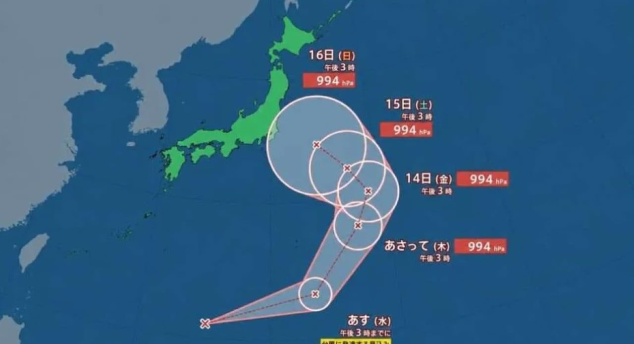
The Japan Meteorological Agency has indicated that a tropical depression south of the country is expected to intensify and become a new typhoon by 3 pm on August 12. If the prediction is confirmed, the system will receive the number 17. It will be able to approach the Kanto region on August 16th.
Initially, the trajectory of the new typhoon points to the northeast, with a gradual change of direction from August 14, heading northwest. On August 16, the projection shows the system located east of Japan.
Understand the risk area on weather maps
Weather maps represent the area where the center of a typhoon has a 70% probability of being. For the new system, part of this area could reach Kanto around 3pm on August 16th. This signals a considerable risk of the phenomenon approaching the region, requiring constant surveillance.
Current situation with Typhoon 15 over Kanto
Currently, typhoon number 15 is already affecting the Kanto region, with landfall expected on the night of August 11th. At 4pm that day, the system was over the sea, approximately 110 kilometers east of Mito, Ibaraki Prefecture. It was advancing west-southwest at a speed of 30 km/h.
Learn more: Typhoon No. 6 hits southern Japan with alert level 4 and threatens the Pacific coast this Wednesday
The meteorological phenomenon gained strength, recording a central atmospheric pressure of 980 hectopascals. Maximum winds near the center reached 90 km/h, with gusts of up to 126 km/h, strengthening wind currents in the east and northeast of Japan.
Meteorological Agency safety recommendations
The entry of humid air, driven by the typhoon, is expected to increase the accumulated volume of rain until August 12th. Given this scenario, the Meteorology Agency recommends paying attention to the following risks:
- Landslides
- Flooding in low-lying areas
- Rising levels and overflowing rivers
- Strong winds
Impacts on transport during the Obon holiday
Typhoon number 15 has already severely impacted the transport system during the Obon holiday. On the JR Joban Railway, two Hitachi express train round-trip services were suspended between Sendai and Iwaki in Fukushima Prefecture.
As of 3pm on August 11, 64 flights were canceled by the main airlines, with a greater concentration of departures and arrivals at Haneda and Narita airports. All Nippon Airways canceled 58 operations and Japan Airlines suspended another six. In addition, Ibaraki Kotsu reported the suspension, for the entire day of August 12, of buses connecting locations in Ibaraki Prefecture to Haneda Airport.
Losses to travelers and local events
Changes in timetables and cancellations of flights and trains affected travelers who were traveling to visit family or take advantage of their time off. Additionally, some summer festivals and fireworks shows in the region have had to be canceled or postponed. Companies warn of the possibility of further delays and cancellations.